GISGeography
  • Analysis
  • Career
  • Datasets
  • Mapping
  • Sensors
  • Software
  • US Maps
  • World Atlas

Month: April 2014

Equal Interval Classification Map
Maps & Cartography

Equal Interval Classification in GIS

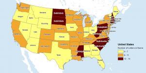
The equal interval classification method divides attribute values into equal size range taking the data’s minimum and maximum values.


Subscribe to our newsletter:


RECENT POSTS
  • 5 Best Free LiDAR Software Tools and Applications
  • Best of GISGeography.com in 2020
  • How To Permanently Reorder Fields in ArcGIS
  • Mapbox Review: 5 Things We Like
  • What Exactly Is a GIS Specialist?
ABOUT US
  • About Us
  • Articles
  • How To Cite
  • Privacy Policy
  • Resources
  • Sitemap
  • Terms of Service
CATEGORIES
  • Analysis
  • Career
  • Cartography
  • Data Sources
  • LiDAR
  • Learn GIS
  • Map Collections
  • Remote Sensing
  • Software
Follow Us

twitterrss

GIS Store

GISGeography.com

css.php