What Is Terrestrial Laser Scanning?
Terrestrial laser scanning is a LiDAR system different from airborne systems. Terrestrial LiDAR generates a point cloud at ground level.

Terrestrial laser scanning is a LiDAR system different from airborne systems. Terrestrial LiDAR generates a point cloud at ground level.

Landsat’s Thermal Infrared Sensor (TIRS) measures the Earth’s surface temperature by focusing on the infrared part of the light spectrum.

UAV mapping has changed how we do aerial surveying. With drones, we can now map areas quickly, accurately, and in a cost effective way.

GNSS vs GPS: GNSS is an umbrella for multiple navigational satellites. Under this umbrella, GPS, along with other systems, finds its place.

While traditional images are taken from directly above, oblique imagery captures them at an angle. Learn more about oblique images.

Can you use GPS without the Internet? Yes, GPS works without the internet. A GPS receiver works by receiving signals from satellites.
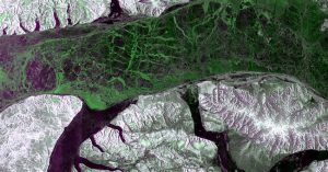
The RADARSAT Constellation Mission (RCM) consists of three satellites. Using SAR, these satellites can see through clouds and darkness.

What if we could use sound to explore underwater? Sonar does just that. Simply, sonar turns sound waves into a map of the ocean floor.
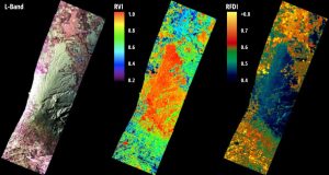
Radar bands are groups of wavelengths. Each has its unique ability to penetrate the Earth’s surface and reveal aspects of the environment.

As Tolkien once said, “Not all those who wander are lost”. This is especially true when we consider the role of waypoints in guiding paths.