Raster Clip in GIS
Learn how to clip rasters in ArGIS using the raster clip tool in ArcToolbox as well as the clip button as part of the Raster Functions.
Learn how to clip rasters in ArGIS using the raster clip tool in ArcToolbox as well as the clip button as part of the Raster Functions.
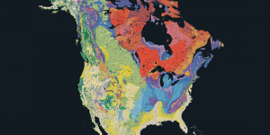
Geology maps depict where the underlying rock formations are. It displays rocks of different ages showing eras, periods and epochs.

The image analysis toolbar can generate NDVI maps in ArcGIS. NDVI shows areas of high and low vegetation and requires red and NIR bands.