What Are Contour Lines on Topographic Maps?
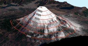
Contour lines have constant values on them such as elevation. But it’s also used in meteorology (isopleth), magnetism (isogon) & even drive-time (isochrones)
Contour lines have constant values on them such as elevation. But it’s also used in meteorology (isopleth), magnetism (isogon) & even drive-time (isochrones)

Map distortion is best understood looking at Tissot’s indicatrix. It contains circles and shows how map projections distort shape, size and distances.

Have you ever wanted to create interactive web maps for your organization? Or how about the whole world? You can with Esri’s cloud-based ArcGIS Online.

While geosynchronous satellites can have any inclination, the key difference is that satellites in geostationary orbit lie on the same plane as the equator.

Some things in life are certain. In ArcGIS, it’s the Esri 999999 error. Here are techniques to troubleshoot this ArcMap error.