An Introduction to Esri ArcGIS Online (AGOL)
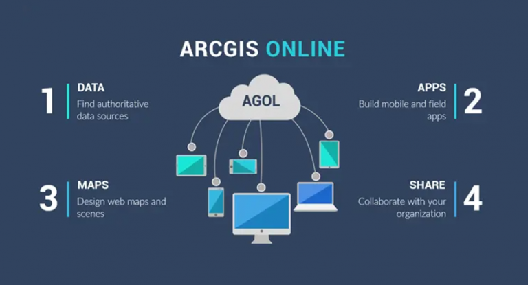
ArcGIS Online (AGOL) is Esri’s cloud platform
Have you ever wanted to create interactive maps for your organization? How about for the whole world to see?
With little effort, you can build them using ArcGIS Online (AGOL). Its interface equips you with base maps and data layers created by the global community.
You can also store your data and build apps through AGOL. This in itself sends a powerful message with the location in mind.
But what else can you do? Let’s take a deep dive into 5 reasons how Esri ArcGIS Online can help you achieve whatever your webmap goals may be.
1. Data in the Cloud
ArcGIS Online keeps the user in mind. It’s really easy to pick up and create beautiful 2D and 3D web scenes. Complete arsenal of geographic data” is an understatement.
No one has really measured the sheer size of Esri’s ArcGIS Online GIS data repository, but confidently it’s the largest that exists today. All things considered, there is a tremendous amount of content for you and your organization as part of Esri ArcGIS Online.
For example, a small search for the environment brings you 6315 data layers.
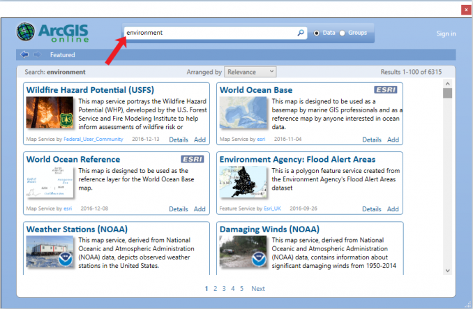
This is some pretty powerful stuff as the cloud-based warehouse continues to expand. Save your favorite data sets because it’s about search and discovery.
Esri has become the ultimate collector of GIS data, in a good way. It never hurts the end-user to have updated data from reliable sources.
…not to mention, the basemaps are simply beautiful. They’ve come a long way:

Now, what can you do with all this data?
2. Apps For the Field
Ok, you won’t be able to build an app for your grandma’s 1990s flip phone.
But you can build some pretty neat web maps and applications for your smartphone and target audience. And you don’t need to be a cartographer or a programmer to create one, even though these skills are very useful.
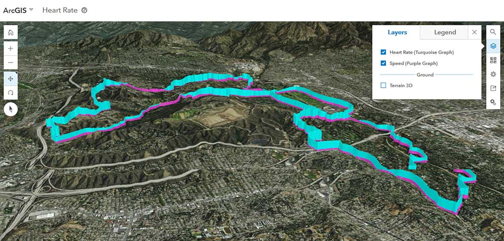
Beautiful, realistic 3D scenes in your web viewer are now a reality such as this GPS map displaying a cyclist’s speed and heart rate. When going uphill, cyclists’ speed tails off in purple, and heart rate shoots up like a rocket in turquoise.
There’s nothing better than telling your own personalized journal on a story map. Like a novel you can’t put down, story maps set the tone with location bookmarks as if you’re going through a storybook page by page. For example, the Introduction to Sea Ice story map describes in great detail the mass of frozen water around each of the planet’s poles.
READ MORE: 15 Examples of How To Use Esri’s JavaScript API
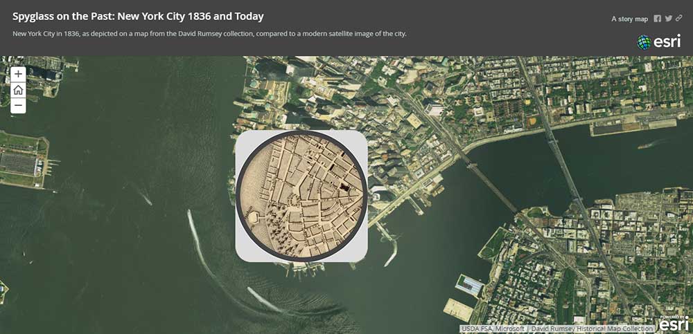
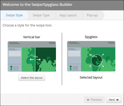
For any time-aware data, the time slider app can filter out data for specific time periods. It can show how earthquakes in an area have increased over time or how the land cover has changed. Like a time capsule, the spyglass and swipe tools are built-in templates that let you time-travel in history. With the New York Spyglass web map, you can spy on New York City from 1836 and today.
Whether you want to explore your data with elevation profiles, viewsheds, or route directions, Esri ArcGIS Online has an app for you. For those in need of statistics in specific areas, the dashboard Summary Viewer solution template is your solution.
3. Design Web Maps
In this section, we’ll provide you with an introductory tutorial on how to create web maps and scenes in AGOL.
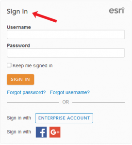
Step 1. Log into your ArcGIS Online account
If you want to create an interactive web map with ArcGIS Online, you will need to create an account. Once your account has been approved, you can start interacting with the tools to build web maps, scenes, and apps in ArcGIS Online.
After a bit of waiting, you’ll have to log in to your ArcGIS Online.
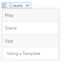
Step 2. Create a Web Map
The next step is to start creating a web map, web scene, or app. But what’s the difference between them?
WEB MAP: A web map is a simple 2D viewer for geographic data. This 2D data could be vectors such as points, lines, or polygons. And it can even include tables or rasters.
WEB SCENES: A web scene is a type of 3D viewer. Generally, the two types of scenes are local and global. For local scenes, the study area is small like a neighborhood. But for global scenes, the study area is much larger like a continent or ocean.
WEB APP: Finally, a web app is a way to customize your web maps or web scenes. For example, you may want to build a story map, collect/edit data or add basic functionality like these 15 high-tech web maps and web scene examples using Esri’s JavaScript API
Let’s start by creating a simple web map. But you can apply the same steps below to web scenes.
Step 3. Add Title and Tags
The simplest option is to create a basic web map. If you select this option, you will have to provide a title and tags.
Once you’ve provided this, suddenly an empty web map appears in your browser. This is the interface for how to create your web map. In the screenshot below, we list some of the important tools to get started.
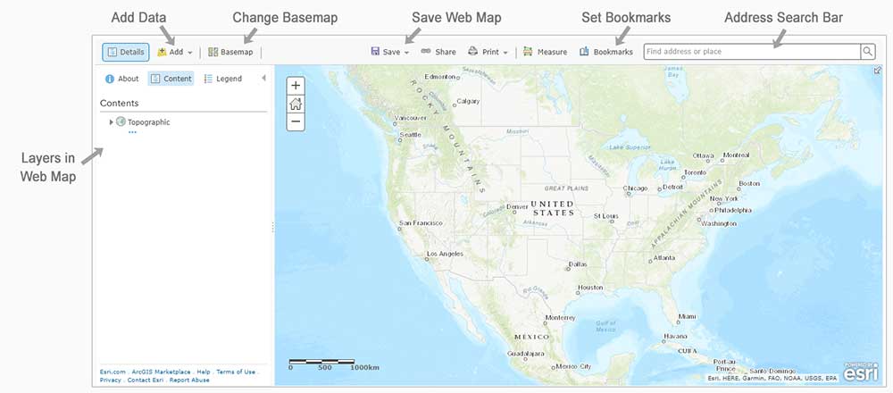
Step 4. Change the Basemap
The default base map is the “Topographic Basemap”. But you can change the base map by selecting the dropdown. For example, there are base maps for “World Imagery”, “Terrain”, “Streets” and “Oceans”.

In this example, we select the “Dark Gray Canvas” base map.
Step 5. Add Data to your Web Map
Instead of a plain web map with only a base map, we should add data to it. And one of the reasons why ArcGIS Online is so good is because users can access and add an incredible amount of data to their web maps.
When you click the “Add Button”, there are select several options to add data.
SEARCH FOR LAYERS: When you search for layers, this is the massive cloud database as part of ArcGIS Online. You can find anything here which includes authoritative and non-authoritative (so be careful). As of now, there are more than 500,000 layers.
ADD LAYER FROM WEB: This option is how to reference web services online. This usually is in the form of REST services, that you have to point to.
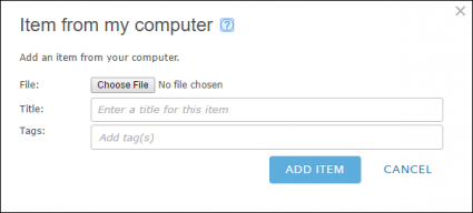
ADD LAYER FROM FILE: If you have your own data on your personal computer, then you can add data as a zipped shapefile, CSV, TXT, GPX, or GeoJSON.
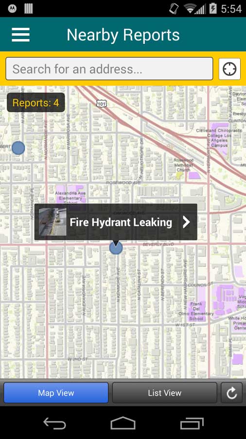
USE MAP NOTES: This is how to mark up the web map with basic shapes. For example, AGOL has map note templates for infrastructure, civic events, and citizen requests.
In our map, we have added earthquake events using the “Search for Layers”. Earthquake events are highlighted as orange points.
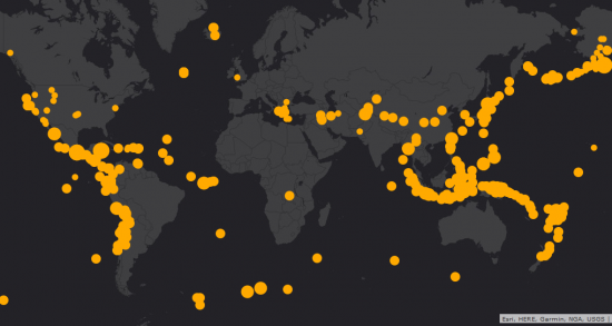
So in the end, your webmap can look anything similar to the one above… or however you decide to customize it.
Chapter 4. Share and Collaborate
Finally, you can share your web map. Once you click the share button, you can alter who can view the map. If you want the whole world to see, then you can select the check box for everyone.
Alternatively, you can share the map with a simple link. But if you want to embed your web map into a website, it provides code on how to do so. Keep in mind that people can only access your map if you make it public.
If you want to make a web app, you should start with a template.
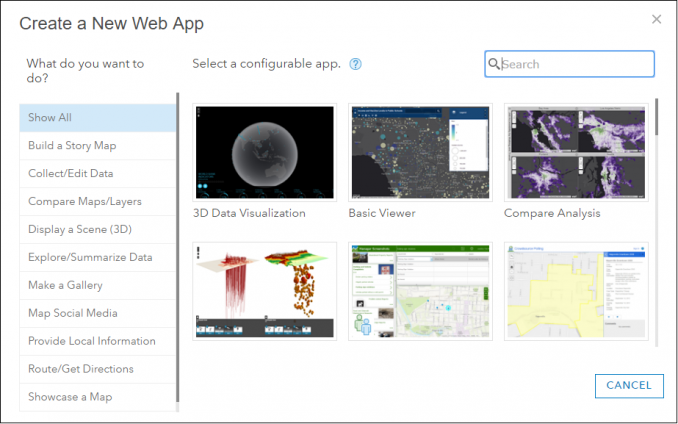
For example, the spyglass template gives step-by-step instructions.
Upload your own data from your personal computer. Alternatively, you can select a web service or data from ArcGIS Online.
Select your base maps, change symbols, customize pop-ups and share. As you can see, ArcGIS Online requires zero programming skills because there are templates available for you to get started right away.
It’s really as simple as that.
Next Level Web App Customizing
In ArcGIS Online, you can create apps by using a template or using the Experience Builder.
But just what is Experience Builder?
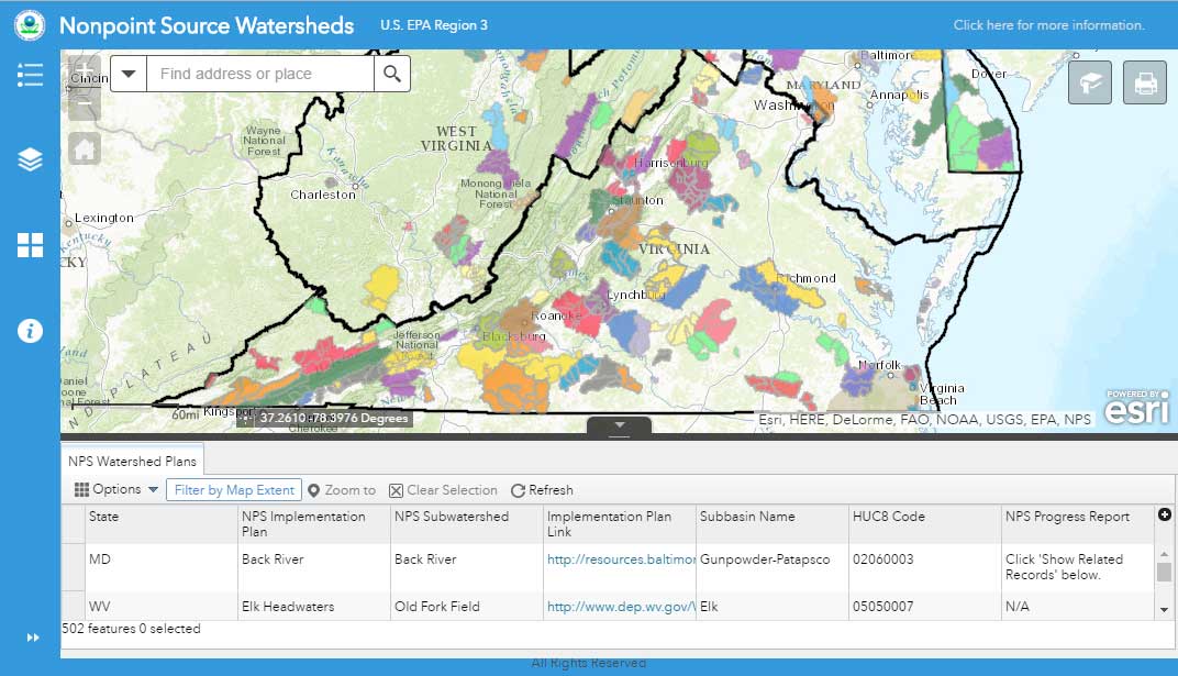
If you want to customize your web maps, Experience Builder is a drag-and-drop type of interface to customize your web apps without code. It’s you who decides which widgets will be in your application like this EPA web app has its widgets on the left and top-right.
You can usually recognize one when you see one because of its similar widget menus. But as the web app builder continues to evolve you can begin publishing geoprocessing widgets to automate monotonous tasks like clipping. Imagine that!
Sounds tough? Don’t worry because it isn’t.
Lastly, if you have field crews that collect/edit data, ArcGIS Online provides an entry “geoform” on top of Esri Collector. If you want to test out this field app, download it for free at the Android Play Store or Apple App Store.
If you need to crowdsource or create a poll to get feedback, ArcGIS Online has a ready-to-use app for that. Again, this requires no programming and just some initial configuration with the Crowdsource reporter app.
Now, what if you want to customize everything on a webpage of your very own?
You can take things a step further with ArcGIS API for JavaScript 3 and 4. Using a bit of JavaScript, you can leverage data stored in your ArcGIS Online portal or ArcGIS Server. ArcGIS JavaScript API 4 lets you build full-featured 3D web scenes and tons more to build a great user experience. But in this case, programming skills are required.
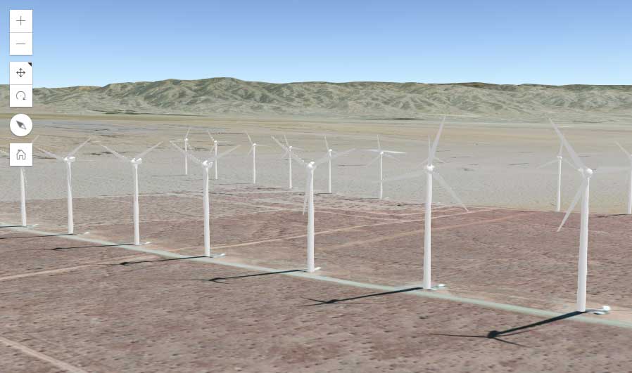
This windmill WebGL web map (as shown above) is just the tip of the iceberg. In a true 3D environment, this wind farm web scene shows all the moving parts of a windmill with orientation and blade rotation speed. It’s from a live service so how cool is that?
Chapter 5. Data Security
When you’ve hoarded your own collection of ArcGIS Online data (or your own private data), you can share it with only your organization or publish it for the world to see.
If you are your organization’s administrator, you can assign control and hand it to various people depending on the content.
Store your public or private data to your favorites… With its secure sharing and collaboration tools, you can share your own data with your organization or the entire world.
Your organization can create and join groups with control access to items shared publicly or within groups.
This is all exciting stuff.
The capabilities in ArcGIS Online almost appear limitless as new developments like Esri Insights are emerging regularly.
Just Touching the Surface with ArcGIS Online
It’s time to sculpt some web maps of your own. As you can see in this tutorial, you can work comfortably and create web maps with ease using AGOL.
In this tutorial, we changed the base map, added data stored in the cloud, and shared it as a public map. Now, you can experiment for yourself with interactive 3D web scenes or customized apps.
The power of GIS is now online with ArcGIS Online for users with all skill levels.
Esri gives a generous 60 days to try for free with 2 GB of storage. However, it does have a limitation on the number of features you can upload.
Overall, Esri has invested a lot of time and effort in making this something for any end-user to pick up and run with. It’s time to give credit where credit is due, and this is a big winner in our books.


