GISGeography
  • Analysis
  • Career
  • Datasets
  • Mapping
  • Sensors
  • Software
  • US Maps
  • World Atlas

Month: August 2017

Synthetic Aperture Radar SAR Image
Remote Sensing

Learn Synthetic Aperture Radar (SAR) by Example

Synthetic Aperture Radar (SAR) is an emerging technology in remote sensing with the advantage to see in any weather condition and even at night.

blue marble global mapper software
Software

Global Mapper Software by Blue Marble (Review)

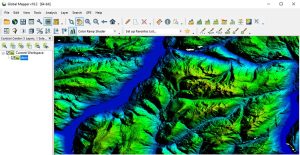
Global Mapper by Blue Marble is a 64-bit user-friendly GIS application. It has powerful, intuitive interface especially with LiDAR and terrain mapping.

shapefile table to excel spreadsheet
GIS Analysis

How to Export a Shapefile Table to Excel Spreadsheet in ArcGIS

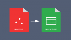
If you use ArcGIS 10.2 and above, you can use the “Table to Excel” tool to convert a shapefile table to Excel spreadsheet & export field aliases / subtypes

what is geofencing
GIS Career

What is Geofencing? A Guide to Virtual Barriers

A geofence is a virtual geographic boundary. Whether it’s for security, retail or delivery, geofencing gives real-time alerts and increases awareness.


Subscribe to our newsletter:


RECENT POSTS
  • 5 Best Free LiDAR Software Tools and Applications
  • Best of GISGeography.com in 2020
  • How To Permanently Reorder Fields in ArcGIS
  • Mapbox Review: 5 Things We Like
  • What Exactly Is a GIS Specialist?
ABOUT US
  • About Us
  • Articles
  • How To Cite
  • Privacy Policy
  • Resources
  • Sitemap
  • Terms of Service
CATEGORIES
  • Analysis
  • Career
  • Cartography
  • Data Sources
  • LiDAR
  • Learn GIS
  • Map Collections
  • Remote Sensing
  • Software
Follow Us

twitterrss

GIS Store

GISGeography.com

css.php