GISGeography
  • Analysis
  • Career
  • Datasets
  • Mapping
  • Sensors
  • Software
  • US Maps
  • World Atlas

Month: August 2018

sentinel satellites copernicus programme
Remote Sensing

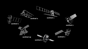
Sentinel Satellites of the Copernicus Programme

Copernicus is the world’s largest and most ambitious Earth observation program in existence today with its Sentinel satellites taking center stage.
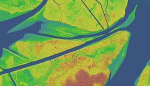
lidar dem
GIS Analysis

LAS Format: Converting LAS Files to DEM with ArcGIS 3D Analyst

How to Create DEMs from LAS files with ArcGIS 3D Analyst Light Detection and Ranging (LiDAR) is a distance technology. It sends a pulse to the ground and waits for that same pulse to return


Subscribe to our newsletter:


RECENT POSTS
  • 5 Best Free LiDAR Software Tools and Applications
  • Best of GISGeography.com in 2020
  • How To Permanently Reorder Fields in ArcGIS
  • Mapbox Review: 5 Things We Like
  • What Exactly Is a GIS Specialist?
ABOUT US
  • About Us
  • Articles
  • How To Cite
  • Privacy Policy
  • Resources
  • Sitemap
  • Terms of Service
CATEGORIES
  • Analysis
  • Career
  • Cartography
  • Data Sources
  • LiDAR
  • Learn GIS
  • Map Collections
  • Remote Sensing
  • Software
Follow Us

twitterrss

GIS Store

GISGeography.com

css.php