What is Geostatistics?
Geostatistics is the study of statistics with a focus on finding patterns of geographic phenomena using variograms, kriging and validation.
Geostatistics is the study of statistics with a focus on finding patterns of geographic phenomena using variograms, kriging and validation.
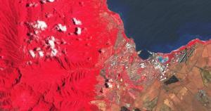
Sentinel 2 has a total of 13 bands. Each band is 10, 20 or 60 meters in pixel size. This includes red, green, blue, near infrared and short infrared bands.
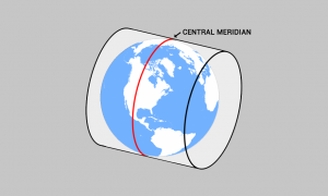
The central meridian is the center line of longitude for projection systems. Projected coordinate systems often use it as a reference point for a x-origin.