World Physical Map
World Physical Map
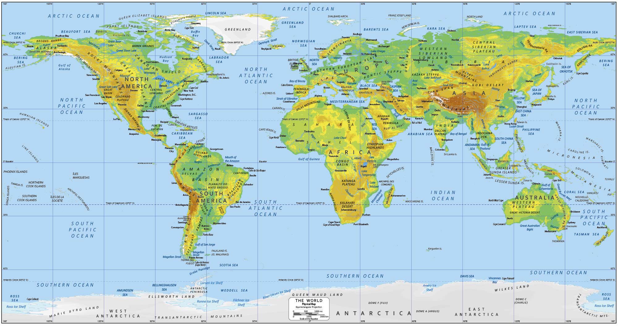
This world physical map is a great way to explore the vastness of our planet, from the highest mountains to the deepest oceans. The purpose of it is for you to gain an appreciation for the incredible diversity of landscapes and topographies that make up the world.
North America Physical Features
Rocky Mountains
Great Plains
Canadian Shield
Labrador
Brooks Range
Barren Grounds
Sierra Madre
Coast Mountains
Central Lowland
Great Basin
Colorado Plateau
Appalachian Mountains
Coastal Plain
Yucatán Peninsula
South America Physical Features
Andes
Amazon Basin
Llanos
Guiana Highlands
Selvas
Brazillian Highlands
Gran Chaco
Atacama
Patagonia
Pampas
Caatingas
Serra Geral
Europe Physical Features
Northern European Plain
Alps
Scandinavia
Peninsula Iberica
Carpathian Mountains
Balkan Peninsula
Anatolia
Pontic Steppe
Caucasus Mountains
Asia Physical Features
Zagros Mountains
Siberia
Ural Mountains
Western Siberian Lowlands
Central Siberian Plateau
Kazakh Steppe
Himalayas
Deccan Plateau
Altay Mountains
Gobi Desert
Yucatán Peninsula
Verkhoyansk Range
Kolyma Range
Kamchatka Range
Indochina Peninsula
Arabian Peninsula
Rub’ Al Khali
Oceania Physical Features
Great Victoria Desert
Great Dividing Range
Western Plateau
Great Barrier Reef
Africa Physical Features
Sahara Desert
Sahel
Atlas Mountains
Libyan Desert
Ethiopian Highlands
Congo Basin
Katanga Plateau
Namib Desert
Kalahari Desert
Antarctica Physical Features
Ellsworth Land
Transantarctic Mountains
Marie Byrd Land
Queen Maud Land
Wilkes Land
Ross Ice Shelf
What is a World Physical Map?
From the Rocky Mountains to the Gobi Desert, a world physical map is a type of map that allows you to explore the world’s natural landscapes. It offers a unique perspective of the world without the display of administrative boundaries. You’ll be able to visualize topography and labels of key physical features from around the world. These features include:
We hope that you’ve enjoyed our world physical map. Overall, it’s a great way for you to explore the vastness of our planet and get better acquainted with its physical features.
What about the mountains?
Mountain ranges are on the map
Helped me a lot
good map
gooooooood map
Put the contries name
Right now my grandparents, aunt and uncle live in Ural Mountains region!
Great map 10/10 love it
I like this map
This map is great:)
keep all the latitude and longitude in the map
The map would be too busy if we kept all the latitude/longitude lines in the map
No Major Rivers?
This is a great suggestion for another map. We’ll consider making one.
Name the mountain ranges
Excellent material for us, as teachers! Thanks a lot!