GISGeography
  • Analysis
  • Career
  • Datasets
  • Mapping
  • Sensors
  • Software
  • US Maps
  • World Atlas

Month: February 2017

Conflation
GIS Analysis

What is Conflation, Edge Matching and Rubbersheeting?

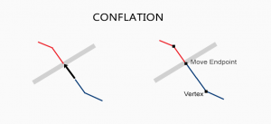
When you have two conflicting data sets, conflation resolves conflicts by preserving the most accurate one. Edgematching and rubbersheeting helps fix errors

State Plane Coordinate System Map Projections
Maps & Cartography

The State Plane Coordinate System (SPCS)

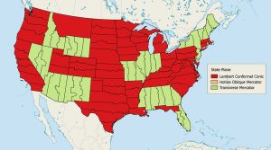
The State Plane Coordinate System divides the United States into 124 zones to locate any point with a high level of accuracy (one part in 10,000).

kriging prediction standard error
GIS Analysis

Kriging Interpolation – The Prediction Is Strong in this One

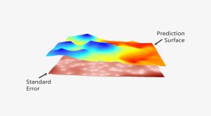
The prediction is strong in kriging. In this guide to geostatistics we embark on a journey to sculpt a legendary prediction model with kriging interpolation


Subscribe to our newsletter:


RECENT POSTS
  • 5 Best Free LiDAR Software Tools and Applications
  • Best of GISGeography.com in 2020
  • How To Permanently Reorder Fields in ArcGIS
  • Mapbox Review: 5 Things We Like
  • What Exactly Is a GIS Specialist?
ABOUT US
  • About Us
  • Articles
  • How To Cite
  • Privacy Policy
  • Resources
  • Sitemap
  • Terms of Service
CATEGORIES
  • Analysis
  • Career
  • Cartography
  • Data Sources
  • LiDAR
  • Learn GIS
  • Map Collections
  • Remote Sensing
  • Software
Follow Us

twitterrss

GIS Store

GISGeography.com

css.php