Antarctica Map and Satellite Image [Free]
The Antarctica Map Collection
If you’re searching for an Antarctica map to hang on your wall, then we just may have the trick for you.
Today, we’ll unveil some of the best maps of Antarctica including:
- Antarctica without ice
- Major landmarks of Antarctica
- An Antarctica satellite map
Let’s dive right in.
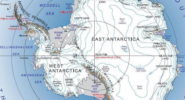
1. Antarctica Map with Landmarks
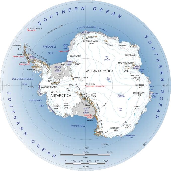
Antarctica is unique because it’s still relatively unchanged. For example, you’ll mostly find massive ice shelves, mountains, and subglacial lakes.
No one permanently lives in Antarctica. The only residents are temporary researchers and travelers.
So, Antarctica doesn’t have any populated places with official “city” status. But it does have some notable landmarks.
2. Süd-Polar-Karte
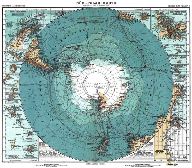
In 1912, August Petermann drafted this vintage map of Antarctica called “Süd-Polar-Karte”. The purpose was to trace out Antarctic expeditions with dates.
In a southern polar projection, thirteen inset maps surround the main map. Each one displays the surrounding islands of Antarctica.
I’m at a loss for words for how stunning it looks. Language is in German at a scale of 1:40,000,000.
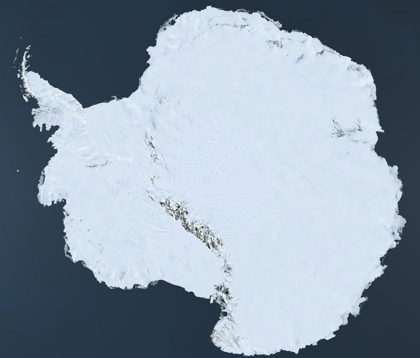
3. Blue Marble Antarctica Satellite Map
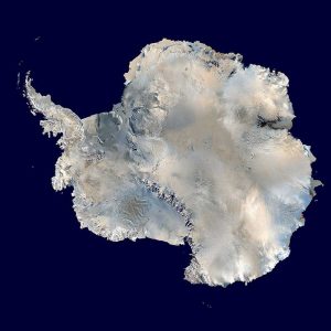
Introducing: NASA’s Blue Marble of Antarctica. This cloudless composite displays the prestigious continent of Antarctica.
You probably know Antarctica as that big, cold, white continent at the bottom of the world. And you’re right! It’s 98% ice. If you compare this on a global scale, it holds 90% of the world’s ice!
In this selfie of the South Pole, you can see how the “white continent” earned its nickname.
Pixels are 1km resolution. It uses MODIS with an orthographic projection. Astonishingly, you can even get better detail in Blue Marble Next Generation. It sharpens pixels to 500m pixels.
4. Map of Antarctica Research Stations
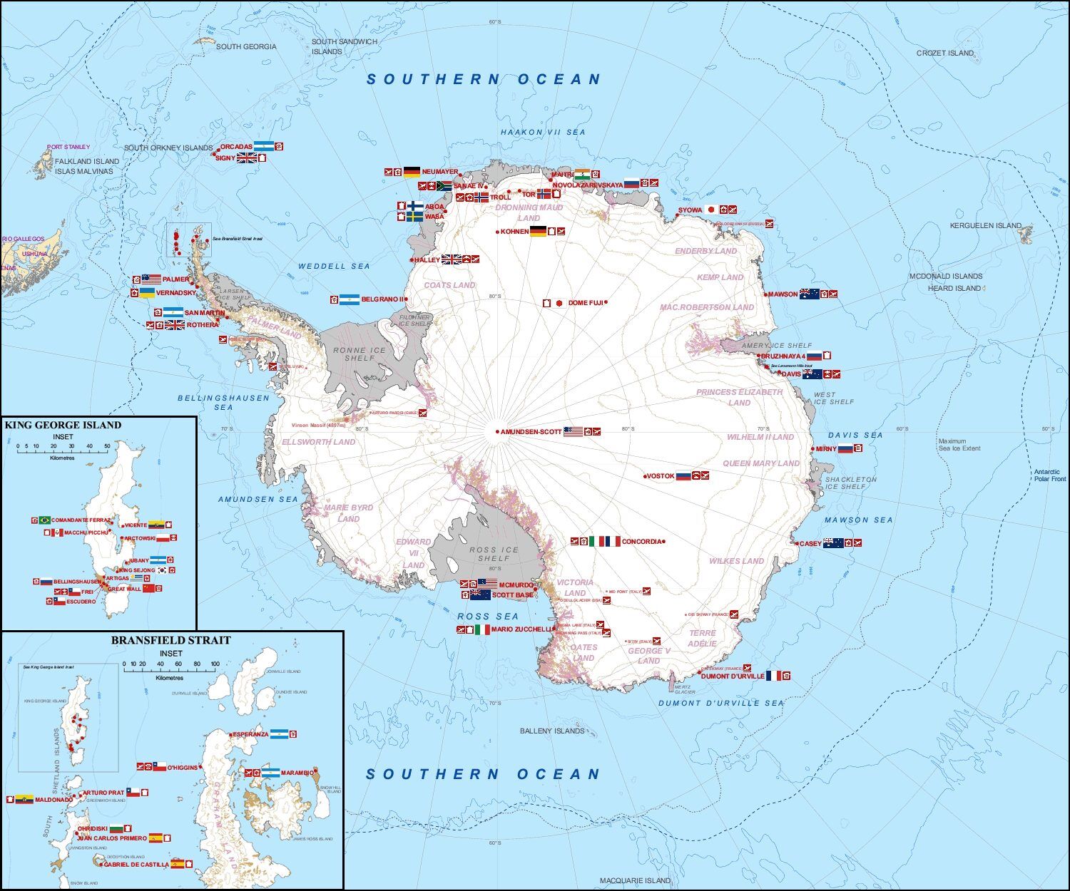
Antarctica is just a bunch of research stations (115 or so) scattered across the continent. Each staff has about 50-150 people. As mentioned, it doesn’t have any cities whatsoever. Popular travel facilities include Halley, Port Lockroy, and Villa Las Estrellas.
The most renowned research bases are Amundsen-Scott and McMurdo stations:
- AMUNDSEN-SCOTT: Amundsen-Scott is just a couple hundred meters away from the true South Pole.
- MCMURDO: McMurdo is the largest research facility located at the tip of Ross Island.
5. Antarctica Without Ice
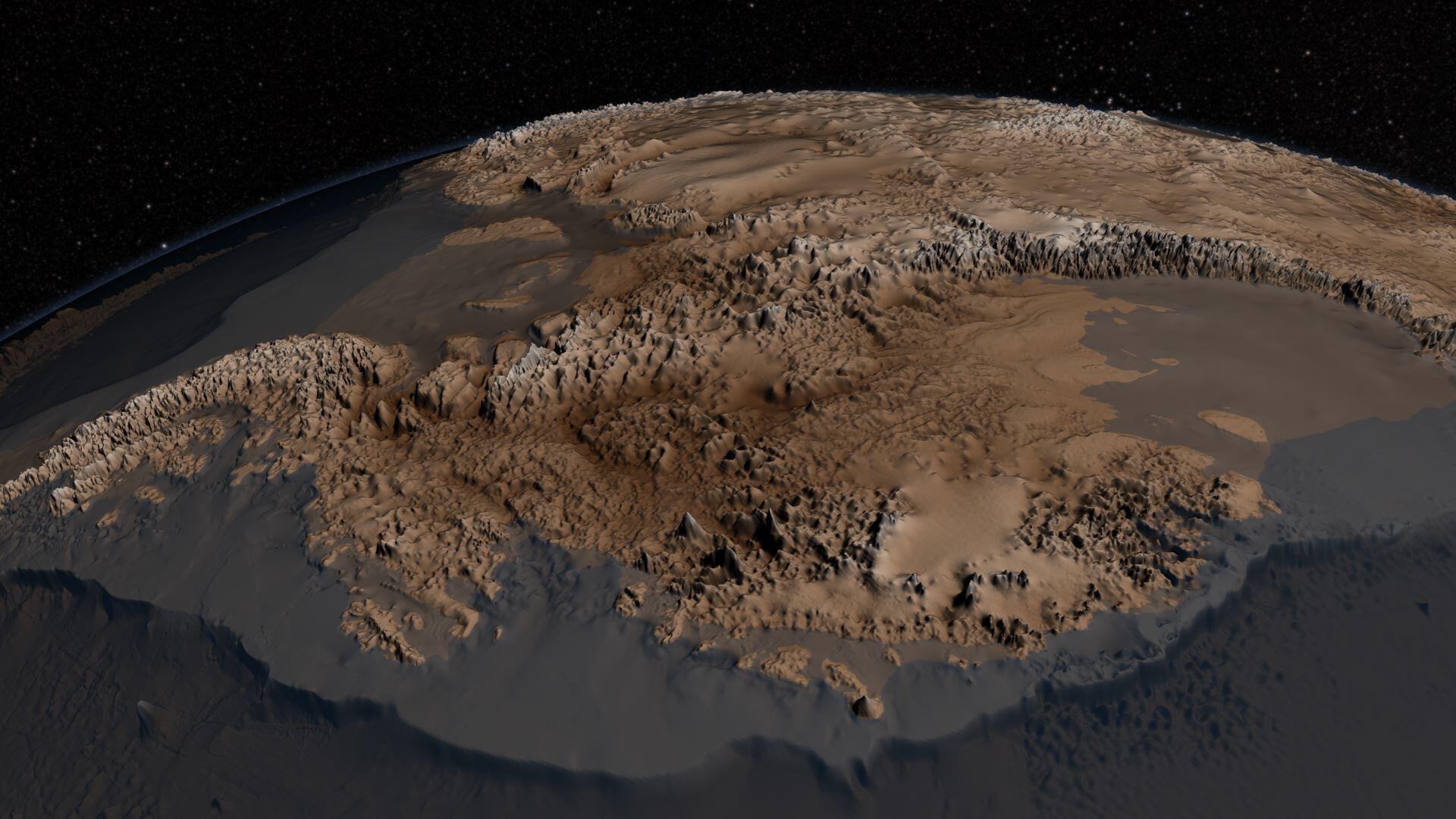
Introducing: The Bedrock Beneath. This 3D map is the only one that shows Antarctica without ice.
NASA built it with over 25 million observations and named it BEDMAP 2.
Knowing bedrock is the only way we can measure ice thickness, melting, and flow. Over time, we can better understand ice melt and climate change.
6. LANDSAT Antarctica Satellite Map
LIMA stands for Landsat Image Mosaic of Antarctica. This mosaic stitches 1000+ Landsat scenes creating the most complete map of Antarctica.
If you want an interactive version, you can view it on the USGS Atlas of Antarctica.
This Antarctica map has everything from geographic names to hydrography, and elevation.
7. Ozone Map of Antarctica
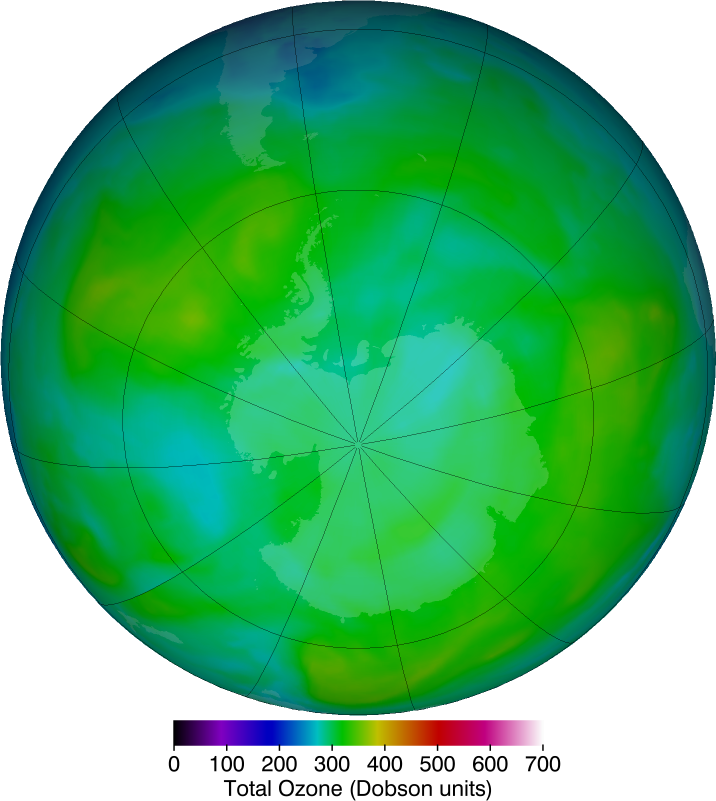
The ozone hole map of Antarctica isn’t flashy or full of color. It’s boring and bland. But that’s how I like it because it means the hole in the ozone layer is shrinking.
In fact, NASA states the ozone hole is the smallest it’s ever been on record. So, the ozone hole is one of the rare good news stories we need. This is all thanks to science and taking action on CFCs.
8. Territories Map of Antarctica
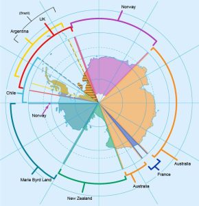
In 1959, 12 countries signed the Antarctic Treaty. Some of the important points in the treaty include:
- Researchers can freely conduct investigations.
- Antarctica shall be for peaceful purposes.
- Countries cannot recognize claims.
So, even if you’re born in Antarctica, no person can lay claim to sovereignty. There are still people of “Antarcticans” descent. But they are a rare bunch. Just 10 people or so were born there.
This Antarctica political map shows all recognized national claimants including:
9. Ice Flow Antarctica Map
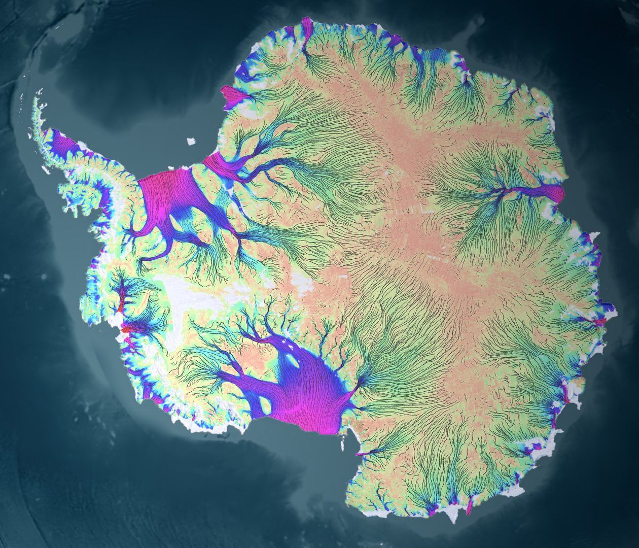
Geographically, Antarctica is surrounded by water. The Southern Ocean envelops it along with several seas. Argentina and Chile are the closest countries. But they are still a good 5,000+ km away.
Miles of ice blanket Antarctica. But when the ice melts, how does it flow? As a system of tributaries, this map shows Antarctica as a system of rivers and creeks. Colors represent the velocity of ice flow.
10. Antarctic Animals Map
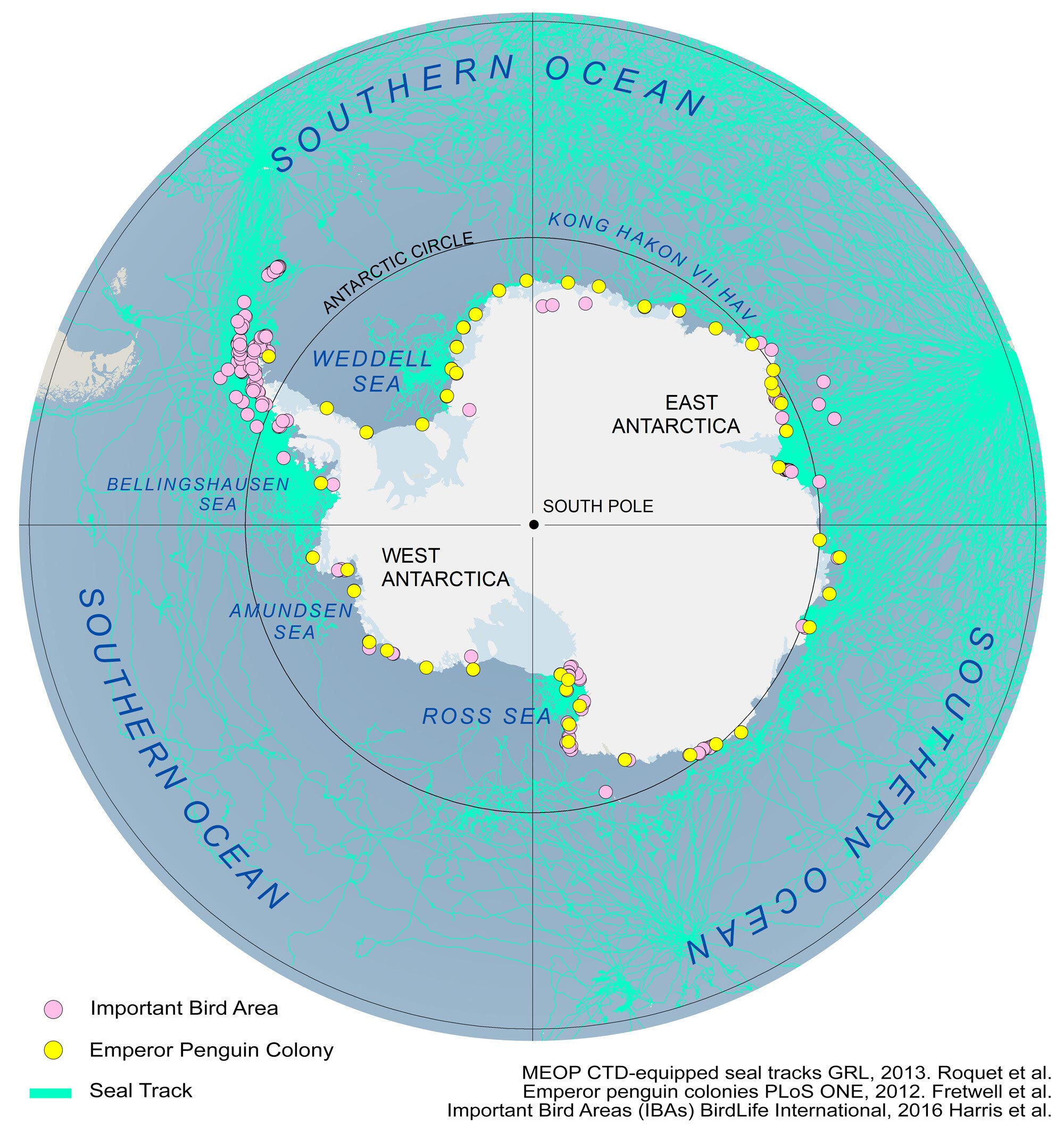
One of the surprising things about Antarctica is that it has a diverse ecosystem. In fact, it has things you wouldn’t expect like microbes.
Antarctic animals have adapted to living under the harshest conditions. Penguins, seals, and whales are all warm-blooded. But they all have a thick layer of blubber to protect them from the cold.
In this Antarctica map, the paths show animal movement. See how they travel around the frozen terrain and ocean. The tracks include emperor penguins, seals, and important bird areas.
Conclusion
GIS fueled the creation of these maps.
If you want to learn more about the data behind some of these maps, be sure to check out Quantarctica. Or better yet, read our article on Antarctica data sources.
Now, we want to hear from you:
How did you like the Antarctic maps? Is there anything we missed? Please let us know with a comment below.
References
- Petermann, A. (1912) Süd-Polar-Karte. [S.l] [Map] Retrieved from the Library of Congress, https://www.loc.gov/item/2002624041/.
- Council of Managers of National Antarctic Programs (COMNAP) Listed Facilities, 2017.
- LIMA Landsat Image Mosaic of Antarctica (15/240m) USGS / Rem. Sens. Environ., 2008. Bindschadler et al.
- RAMP RADARSAT mosaic (100m) NSIDC, 1999/2013. Jezek et al.
- MEOP CTD-Equipped Seal Tracks. GRL, 2013. Roquet et al.
- Emperor Penguin Colonies. PLoS ONE, 2012. Fretwell et al.
- Important Bird Areas (IBAs) BirdLife International, 2016. Harris et al.
- MODIS mosaic (125m) NSIDC, 1999/2013. Haran et al., Scambos et al.
- BEDMAP2 (1km) BAS/The Cryosphere, 2013. Fretwell et al.
Beautiful collection of maps. Thank you. I will use them in presentations on brain-structure observations of Antarctic winterover people at Concordia Station if I may.
There aren’t real sat images of all antarctica and of south pole. Why you hides all? is there a great secret you hide from us?
Which parts are we missing?
You brought up an interesting point. I have heard there is a lake beyond the ice wall. True or false?
Philatelist here, would like to thank you for the maps. I am enjoying the Australian issues of Antarctic stamps and decorating my collection albums with country maps. Your site has been a great help, and is much appreciated, full of useful information for the inquisitive person.
Thanking you.
These are amazing. Thank you for such a variety of maps.
See Admiral Byrd’s secret diary, Amazing.
https://www.youtube.com/watch?v=0ybWK61XxOc
Hi Jeff,
the link you posted was taken off of youtube which makes me even more interested in his secret diary
I was interested in topography, specifically mountains. Any caverns or tunnels beneath?
I think we need to base our studies on Admiral Burg’s findings and learn more about Antarctica and its natural resources no on my
BEDMAP2 & Ice flow & ANimals & territory maps = 😃
Good maps! Really useful!
I particularly liked the ozone map!
Good morning I have just found your information site I was trying to locate Vostak– station AAT on your map.
Just a person with a hobby I like to locate the coldest temperatures on earth 🌏.
I wintered over 67 – 68. Was stationed at Brockton station for a few weeks. Was weather observation station for flights to and from Byrd Station and the South Pole. Know it was on Ross sea ice shelve.
It is a very useful resource. I am yet to locate satellite-based images and whether time-lapse multidate images are made available.
But before that may I suggest the addition of airstrips and the location of places where aircraft land. One such place is Moldezanya Russian Station in East Antarctica and near Indian Station Maitri where our IL-76 landed in Nov. 2003.
Where are the Southern Lights? The North Pole has the Northern Lights. Is there such a phenomenon, as the Southern Lights? My guess is that there are no known lights in Antarctica. Rationale: Compare a simple magnet to the earth poles and the activity n magnetic force at the North Pole end only and the South Pole appear at rest, hence no Southern Lights. Are these forces really at rest? I do not think so. Any comments appreciated.
I’m interested in whether or not the ice is going to be depleted or not.
Great maps. You misspelled McMurdo station. In your story you have it listed as Mccurdo, this is incorrect. Everything else is spoton
Thanks, I fixed it
Very interesting and very useful, for a variety of reasons. I’m glad to know that it has finally been seen fit to let the general public understand various aspects of Antarctica. Too long needed. However, the ‘territories’ map harkens back to the era when only certain countries were allowed to carve out territories on Antarctica for themselves, at the expense of less we’ll-endowed nations that also have an interest in performing research there. Those days should be gone, as Antarctica is truly a ‘whole-world’ resource! That fact should be said out loud at all times. Thank you.
BLM
Can we use these maps for research publications?
Can you email us about which ones you would like to use?
What is this in Antarctica?
The google satellite maps location is -70.15789161771542, 87.81720434805605
or 70°09’28.4″S 87°49’01.9″E
The distances:
Distance to the Davis Station is 425 km
Distance to the Casey Station is 1028 km
Distance to the South Pole is 2016 km
What about historical changes in ice area and land topography