Dublin Map, Ireland

Map of Dublin, Ireland
Our Dublin map collection provides a bird’s eye view of the city’s layout and transportation network.
In a total of 3 maps, you’ll be able to see its major streets, landmarks, and neighborhoods.
Download them today and explore the capital city of Ireland including its many attractions.
Jump To: Interactive Map | Printable Road Map | 10 Things to Do | Reference Map
Dublin map collection
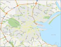
Interactive Map of Dublin
Dublin is the most populous city in Ireland and is located on the east coast of the island. By using this interactive map, you’ll see the latest geographic information available on this multi-layered city. Dublin’s city center is compact and easy to navigate, making it an ideal destination for walking tours.
Major thoroughfares such as O’Connell Street and Grafton Street are pedestrian-friendly, lined with shops, restaurants, and historic buildings. The map also highlights the numerous parks and green spaces throughout the city, such as St. Stephen’s Green and Phoenix Park.
Dublin Road Map
Our road map of Dublin is crucial for anyone visiting or living in the city. It provides a comprehensive overview of the city’s highway network with street names and motorway numbers. So get out today and start exploring Dublin’s rich history and lively city center.
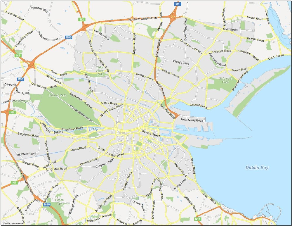
Highways: M1, M50, N2, N3, N4, N7, Western Parkway Motorway
Major Roads: Griffith Avenue, Collins Avenue, Oscar Traynor Road, Cabra Road, Blackhorse Avenue, Chapelizod Road, South Circular Road, Pearse Street, Crumlin Road, Rathgar Road, Navan Road, Wellington Road, Templeogue Road, Rathgar Road, Merrion Road, Strand Road, Rock Road, Butterfield Avenue, Ballymun Road, Main Street
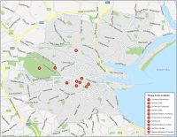
10 Things To Do in Dublin
This map lists out our top 10 recommended attractions in Dublin. One of the most notable features in this map is the River Liffey, which divides the city into two halves: north and south. Many of Dublin’s major landmarks and attractions are located along the river, such as the Ha’penny Bridge, the Custom House, and the Guinness Storehouse.
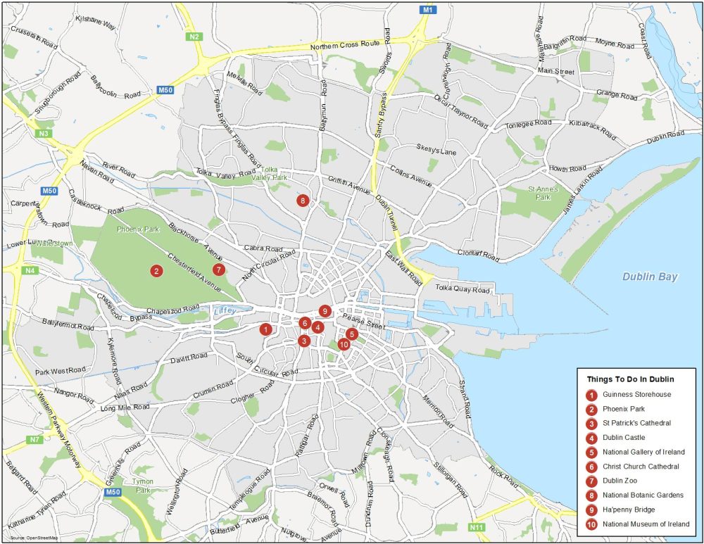
Dublin is the most populous and capital city of Ireland. Here are the top 10 things to do that we recommend doing.
- Guinness Storehouse
- Phoenix Park
- St. Patrick’s Cathedral
- Dublin Castle
- National Gallery of Ireland
- Christ Church Cathedral
- Dublin Zoo
- National Botanic Gardens
- Ha’penny Bridge
- National Museum of Ireland
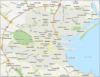
Dublin Reference Map
It’s like Dublin’s neighborhoods each have their own unique personalities. The trendy and bohemian area of Temple Bar is famous for its lively nightlife and cultural attractions, while the leafy suburb of Ballsbridge is home to some of Dublin’s most upscale residences and businesses. No matter how you’re going to use it, this reference map will help you get better acquainted with Dublin.
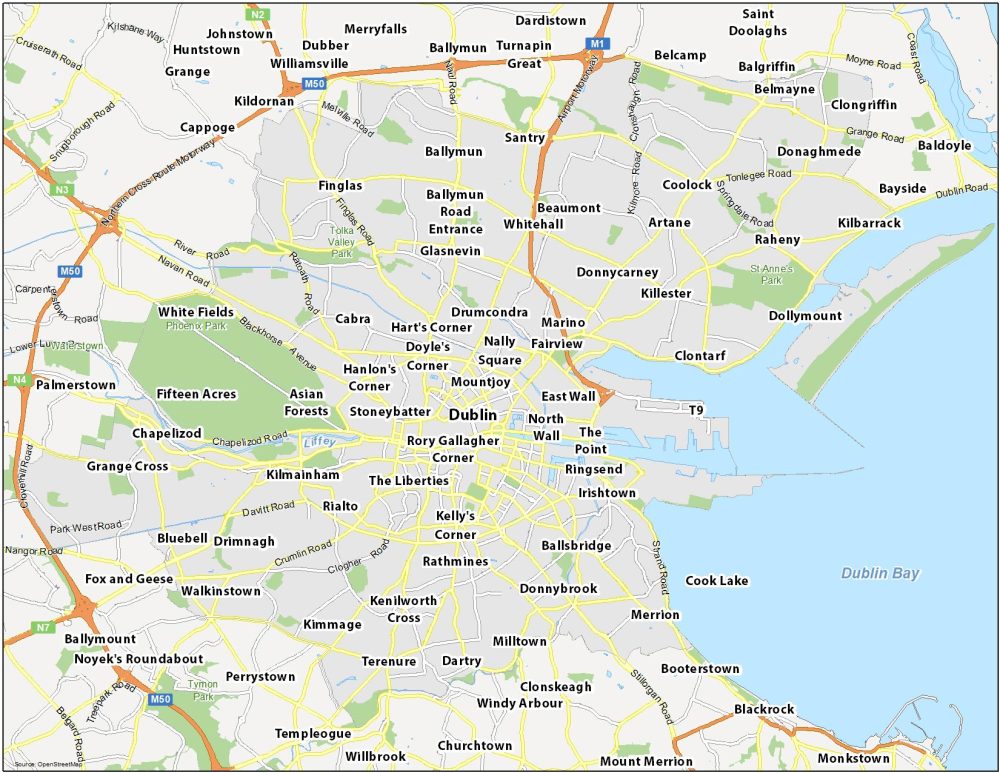
Water Features: Dublin Bay, River Liffey
Parks: Phoenix Park, St Anne’s Park, Tolka Valley Park, Tymon Park, Waterstown
Communities: Stoneybatter, Mountjoy, Doyle’s Corner, The Liberties, Kelly’s Corner, Rathmines, Fairview, Drumcondra, Marino, Cabra, Glasnevin, Chapelizod, Grange Cross, Bluebell, Walkinstown, Kimmage, Kenilworth Cross, Milltown, Dartry, Terenure, Dollymount, Raheny, Kilbarrack, Artane, Coolock, Donaghmede, Ballymun, Cappoge, Belcamp, Balgriffin, Merrion, Ballymount, Churchtown, Blackrock, Monkstown