What is Bit Depth for Satellite Data (and Images)
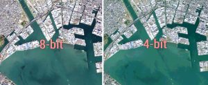
Bit depth is the amount of detail in each pixel expressed in units of bits. 1-bit rasters contain 2 values while 8-bit rasters range from 0-255

Bit depth is the amount of detail in each pixel expressed in units of bits. 1-bit rasters contain 2 values while 8-bit rasters range from 0-255

Deploying efficient raster GIS compression techniques means reducing storage space. It can save money, time and also help network performance.

The main spatial data types are vectors and rasters. Rasters have grid cells while vectors are points , lines and polygons consisting of vertices & paths.

Unsigned integer rasters are non-negative numbers. Signed integers can store negative values. IMG, TIFF & GRID formats are acceptable for signed integer

ArcGIS shapefile files are composed of mandatory files (SHP, SHX and DBF) and optional files (PRJ, XML, SBN and SBX). This article lists their functions.