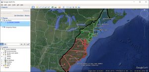
KMZ vs KML: What’s the Difference?
We’ll teach you all the differences between KMZ vs KML. We’ll also show you how to convert them into both file formats in Google Earth.
We’ll teach you all the differences between KMZ vs KML. We’ll also show you how to convert them into both file formats in Google Earth.

As-built drawings are like a diary of a building. They show every detail during construction until completion. They’re the final snapshot.

A web mapping service (WMS) consists of geospatial data hosted on a GIS server with standards set by the Open Geospatial Consortium (OGC).

COGO (Coordinate Geometry) is a tool that maps the geometry from survey plans for land parcels, road allowances, and property easements.

How well do you know GIS formats? This list lets you know all the geospatial data formats that GIS technicians manage, and share data.

Geodata is location data stored in a Geographic Information System (GIS). By using geographic data, we better tackle problems that require spatial thinking.
If you’re a bit confused whether or not to use a file geodatabase (*.gdb) or a personal geodatabase (*.mdb)… Here’s everything you need to know.
Lossless compression (like JPEG) retains values and lowers file size. However, lossy compression (like LZ77) reduces file size by eliminating redundancy.
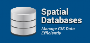
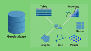
From geodatabases to PostGIS, spatial databases have quickly become the primary method of managing spatial data effectively in a GIS.
Over the years, the USGS has been a driving force in the production of GIS data. The USGS formats we explore are DLG, DRG and DOQ.