GISGeography
  • Analysis
  • Career
  • Datasets
  • Mapping
  • Sensors
  • Software
  • US Maps
  • World Atlas

Month: August 2015

Global Forest Map
Maps & Cartography

4 
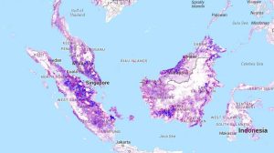
Global Forest Maps to See the Forest for the Trees

Satellite and mapping technologies tell a story of our trees and forests. These 4 global forest maps will help you start seeing the forest for the trees.

capitol building lidar
Remote Sensing

A Complete Guide to LiDAR: Light Detection and Ranging

How would you like to wave your magic wand and find out how far everything is away from you? No magic wands necessary. This is how LiDAR works.

ArcGIS vs QGIS
Software

27 Differences Between ArcGIS and QGIS – The Most Epic GIS Software Battle in GIS History

It’s a head-to-head GIS software showdown with the star-studded lineup in the GIS industry- ArcGIS vs QGIS. Discover the differences between ArcGIS and QGIS


Subscribe to our newsletter:


RECENT POSTS
  • Space-Time Cubes: Stack Time Like Lego
  • Best Handheld GPS Receivers
  • US Election of 2020 Map
  • 5 Best Free LiDAR Software Tools and Applications
  • Best of GISGeography.com in 2020
ABOUT US
  • About Us
  • Articles
  • How To Cite
  • Privacy Policy
  • Resources
  • Sitemap
  • Terms of Service
CATEGORIES
  • Analysis
  • Career
  • Cartography
  • Data Sources
  • LiDAR
  • Learn GIS
  • World Atlas
  • US Maps
  • Remote Sensing
  • Software
Follow Us

twitterrss

GIS Store

GISGeography.com

css.php