Principal Component Analysis (PCA) in GIS
Principal component analysis PCA identifies duplicate data over several datasets & aggregates essential information into groups called principal components.
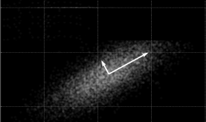
Principal component analysis PCA identifies duplicate data over several datasets & aggregates essential information into groups called principal components.

Multispectral vs Hyperspectral imagery. Hyperspectral contains hundreds of narrow bands. Multispectral usually consists of only 3 to 10 wider bands.

Root Mean Square Error (RMSE) in GIS can be used to calculate how much error there is between predicted and observed values. (ex. error in a DEM)
Follow these quick 5 steps and turn Excel lat long coordinates into spatial data in ArcMap. Set to WGS 1984. Add table. Display XY Data. Export shapefile.

ArcGIS shapefile files are composed of mandatory files (SHP, SHX and DBF) and optional files (PRJ, XML, SBN and SBX). This article lists their functions.

The USGS Earth Explorer is quick and easy to download free Landsat imagery & other remote sensing data. Enter ROI, define timeline and download for free.

Spatial autocorrelation helps us understand the degree to which one object is similar to other nearby objects. Moran’s I is used to measure autocorrelation.
For ArcGIS projections, “define projection” changes the metadata of the current projection. The “project” tool changes the projected coordinate system.

Remote sensing, geodatabases and automation can play a key role in cost-effective and timely information for using GIS in oil and gas industry.
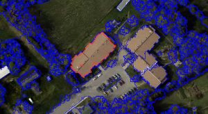
Object-based Image Analysis (OBIA) segments an image by grouping pixels together into vector objects. Using these objects, you classify as land cover types.