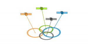
Polar Orbit vs Sun Synchronous Orbit
A polar orbit satellite travels pole-to-pole. For a sun-synchronous orbit, it passes over any given point on Earth’s surface at the same local solar time.

A polar orbit satellite travels pole-to-pole. For a sun-synchronous orbit, it passes over any given point on Earth’s surface at the same local solar time.

NDVI quantifies vegetation health using near-infrared (which is reflected by vegetation) and red light (which is absorbed by vegetation).

The atmospheric window allows specific bands of electromagnetic (EM) radiation to reach the Earth. On the other hand, absorption bands prevent EM radiation.
Have you ever wondered about your GPS accuracy? A well-designed GPS receiver can achieve a horizontal accuracy of 3 meters or better. But factors affect it.

While geosynchronous satellites can have any inclination, the key difference is that satellites in geostationary orbit lie on the same plane as the equator.

Remote sensing is the science of obtaining information without physically being there. The 3 most common methods of capture is airplane, satellite & drones.
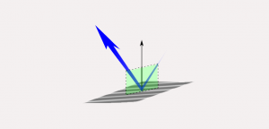
The EM radiation that makes it to Earth is called incident light. From here, Earth’s features reflect, absorb and transmit different amounts of energy.

Supervised classification creates training areas, signature file and classifies. Unsupervised classification generate clusters and assigns classes.

The Landsat file name structure gives you the what, where, when and how the data was captured. (ex. LXS PPPRRR YYYYDDD GSIVV)

If you want to display rasters in true color, you will have to combine the red, green & blue bands. The ArcGIS Composite Bands tool creates RGB composites.