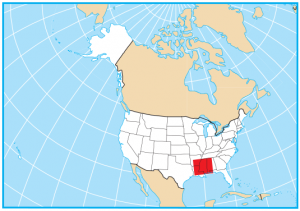
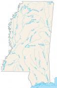
Mississippi County Map
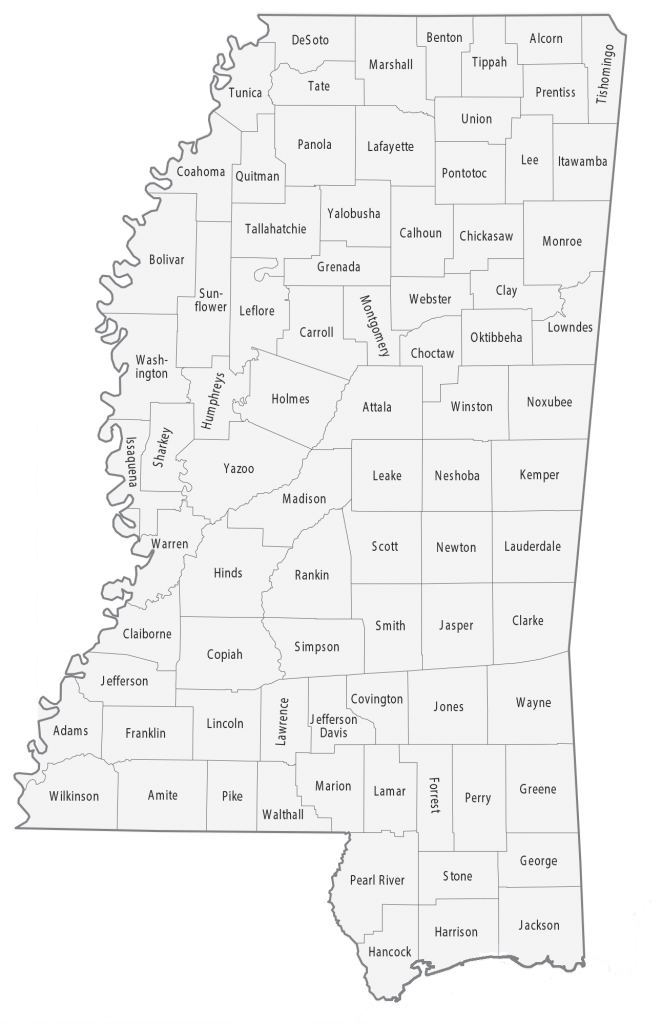
About the map
This Mississippi county map displays its 82 counties. Mississippi ranks 16th for the highest number of counties. The Mississippi River outlines the whole western boundary of the state of Mississippi. Likewise, the Big Black River and Pearl River help determine boundaries for several counties.
The county with the highest population in Mississippi is Hinds County, which is home to Jackson, the state capital of Mississippi. The least populated county in Mississippi is Issaquena County, with just under 1,350 people.
In terms of size, Yazoo County is the largest county in Mississippi occupying an area of 933.9 square miles. Conversely, Alcorn County is the smallest county with just over 400 square miles in size. Both Harrison and Jackson Counties include islands like Cat Island, Horn Island, and Petit Bois Island.

You are free to use our map of Mississippi for educational and commercial uses. Attribution is required. How to attribute?
Mississippi county list
| FIPS Code | Name | Land (sq mi) | Water (sq mi) | Population (2024) |
|---|---|---|---|---|
| 28-001 | Adams County | 462.3 | 25.2 | 28,674 |
| 28-003 | Alcorn County | 400.0 | 1.3 | 34,228 |
| 28-005 | Amite County | 730.1 | 1.5 | 12,451 |
| 28-007 | Attala County | 735.0 | 1.7 | 17,222 |
| 28-009 | Benton County | 406.6 | 2.0 | 7,566 |
| 28-011 | Bolivar County | 876.7 | 29.2 | 28,395 |
| 28-013 | Calhoun County | 586.6 | 1.4 | 12,754 |
| 28-015 | Carroll County | 628.3 | 6.3 | 9,378 |
| 28-017 | Chickasaw County | 501.8 | 2.5 | 16,774 |
| 28-019 | Choctaw County | 418.2 | 1.7 | 8,091 |
| 28-021 | Claiborne County | 487.4 | 13.8 | 8,122 |
| 28-023 | Clarke County | 691.6 | 2.0 | 15,155 |
| 28-025 | Clay County | 410.1 | 5.9 | 18,213 |
| 28-027 | Coahoma County | 552.5 | 30.7 | 20,105 |
| 28-029 | Copiah County | 777.3 | 2.2 | 27,536 |
| 28-031 | Covington County | 413.8 | 1.1 | 18,015 |
| 28-033 | DeSoto County | 476.3 | 20.7 | 195,871 |
| 28-035 | Forrest County | 466.0 | 4.2 | 78,435 |
| 28-037 | Franklin County | 564.0 | 2.8 | 7,516 |
| 28-039 | George County | 478.7 | 5.0 | 25,880 |
| 28-041 | Greene County | 712.7 | 6.0 | 13,675 |
| 28-043 | Grenada County | 422.1 | 27.3 | 20,931 |
| 28-045 | Hancock County | 474.0 | 78.8 | 46,492 |
| 28-047 | Harrison County | 573.6 | 411.0 | 213,730 |
| 28-049 | Hinds County | 869.8 | 7.5 | 211,975 |
| 28-051 | Holmes County | 756.7 | 7.9 | 15,560 |
| 28-053 | Humphreys County | 418.5 | 12.7 | 7,121 |
| 28-055 | Issaquena County | 413.0 | 28.4 | 1,295 |
| 28-057 | Itawamba County | 532.8 | 7.7 | 24,198 |
| 28-059 | Jackson County | 722.8 | 320.6 | 147,002 |
| 28-061 | Jasper County | 676.2 | 1.2 | 15,799 |
| 28-063 | Jefferson County | 519.9 | 7.3 | 6,900 |
| 28-065 | Jefferson Davis County | 408.4 | 0.7 | 11,059 |
| 28-067 | Jones County | 694.8 | 4.9 | 65,837 |
| 28-069 | Kemper County | 766.2 | 0.8 | 8,562 |
| 28-071 | Lafayette County | 631.7 | 47.5 | 59,843 |
| 28-073 | Lamar County | 496.7 | 3.3 | 66,734 |
| 28-075 | Lauderdale County | 703.7 | 11.5 | 70,588 |
| 28-077 | Lawrence County | 430.7 | 5.1 | 11,672 |
| 28-079 | Leake County | 582.9 | 2.5 | 21,462 |
| 28-081 | Lee County | 449.9 | 3.2 | 83,012 |
| 28-083 | Leflore County | 594.1 | 12.3 | 26,157 |
| 28-085 | Lincoln County | 586.1 | 2.0 | 34,956 |
| 28-087 | Lowndes County | 505.4 | 11.0 | 57,210 |
| 28-089 | Madison County | 714.5 | 27.5 | 114,247 |
| 28-091 | Marion County | 542.4 | 6.2 | 24,008 |
| 28-093 | Marshall County | 706.2 | 3.5 | 34,374 |
| 28-095 | Monroe County | 765.1 | 7.0 | 33,483 |
| 28-097 | Montgomery County | 407.0 | 0.9 | 9,411 |
| 28-099 | Neshoba County | 570.1 | 1.5 | 28,973 |
| 28-101 | Newton County | 577.9 | 1.7 | 21,063 |
| 28-103 | Noxubee County | 695.2 | 4.8 | 9,825 |
| 28-105 | Oktibbeha County | 458.2 | 3.7 | 51,965 |
| 28-107 | Panola County | 685.2 | 20.0 | 32,764 |
| 28-109 | Pearl River County | 811.3 | 8.0 | 59,030 |
| 28-111 | Perry County | 647.2 | 3.0 | 11,406 |
| 28-113 | Pike County | 409.0 | 1.7 | 38,980 |
| 28-115 | Pontotoc County | 497.8 | 3.3 | 32,014 |
| 28-117 | Prentiss County | 415.0 | 3.2 | 25,489 |
| 28-119 | Quitman County | 405.0 | 1.4 | 5,542 |
| 28-121 | Rankin County | 775.5 | 30.6 | 160,573 |
| 28-123 | Scott County | 609.2 | 1.2 | 27,666 |
| 28-125 | Sharkey County | 431.7 | 3.4 | 3,234 |
| 28-127 | Simpson County | 589.2 | 1.3 | 25,597 |
| 28-129 | Smith County | 636.3 | 1.0 | 14,051 |
| 28-131 | Stone County | 445.5 | 2.6 | 19,569 |
| 28-133 | Sunflower County | 697.8 | 9.2 | 23,029 |
| 28-135 | Tallahatchie County | 645.2 | 6.9 | 10,921 |
| 28-137 | Tate County | 404.8 | 6.2 | 28,551 |
| 28-139 | Tippah County | 457.8 | 2.1 | 21,423 |
| 28-141 | Tishomingo County | 424.3 | 20.2 | 18,553 |
| 28-143 | Tunica County | 454.7 | 26.1 | 9,157 |
| 28-145 | Union County | 415.6 | 1.3 | 28,363 |
| 28-147 | Walthall County | 403.9 | 0.5 | 13,839 |
| 28-149 | Warren County | 588.5 | 30.0 | 42,105 |
| 28-151 | Washington County | 724.7 | 36.5 | 41,181 |
| 28-153 | Wayne County | 810.7 | 2.8 | 19,749 |
| 28-155 | Webster County | 420.9 | 2.3 | 10,039 |
| 28-157 | Wilkinson County | 678.1 | 9.7 | 7,820 |
| 28-159 | Winston County | 607.2 | 2.8 | 17,418 |
| 28-161 | Yalobusha County | 467.1 | 27.9 | 12,458 |
| 28-163 | Yazoo County | 922.3 | 11.8 | 23,024 |