UAV Mapping for Aerial Surveying
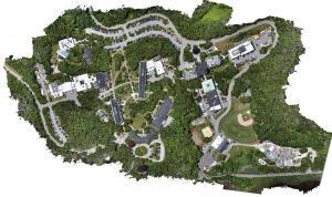
UAV mapping has changed how we do aerial surveying. With drones, we can now map areas quickly, accurately, and in a cost effective way.

UAV mapping has changed how we do aerial surveying. With drones, we can now map areas quickly, accurately, and in a cost effective way.

By combining the panchromatic band with multispectral imagery, pansharpening produces images of higher resolution for better visual clarity.
Photogrammetry uses photographs from at least two different vantage points. It obtains depth and perspective because of separate points of observation.

NDVI quantifies vegetation health using near-infrared (which is reflected by vegetation) and red light (which is absorbed by vegetation).
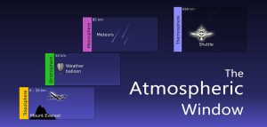
The atmospheric window allows specific bands of electromagnetic (EM) radiation to reach the Earth. On the other hand, absorption bands prevent EM radiation.
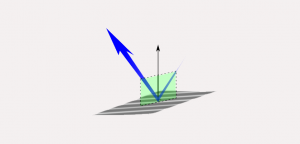
The EM radiation that makes it to Earth is called incident light. From here, Earth’s features reflect, absorb and transmit different amounts of energy.
If you want to display rasters in true color, you will have to combine the red, green & blue bands. The ArcGIS Composite Bands tool creates RGB composites.

Dark object subtraction, radiative transfer models and atmospheric modelling are common techniques used to for atmosphere correction in remote sensing.
This list of earth-shattering remote sensing applications will change the way you feel about how this industry is changing our world and the way we think.