What is Pansharpening in Remote Sensing

What is Pansharpening?
The goal of pansharpening in remote sensing is to achieve the highest level of visual clarity and detail from an image.
Pansharpening improves the quality of a color image. It does this by combining high-resolution panchromatic and multispectral imagery.
This guide to pansharpening in remote sensing will cover its advantages and disadvantages. It will also provide an overview of the software you need and applications of pansharpening.
Overview of Pansharpening
A panchromatic (black and white) band is imagery with high spatial resolution and low spectral resolution. Whereas multispectral imagery has low spatial resolution and high spectral resolution.
By combining these two images, you can create a final image that has both high spatial and spectral resolution. This allows for a more detailed representation of the Earth’s surface.
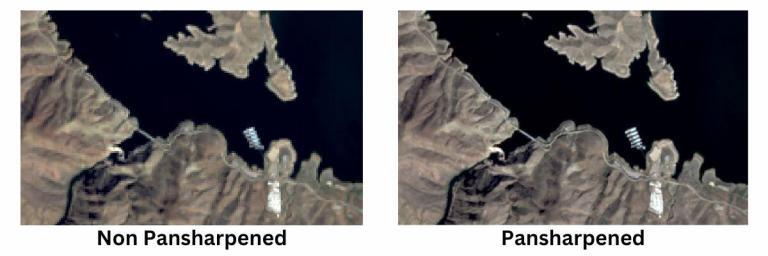
The process of pansharpening applies an algorithm so it can enhance the spatial resolution of the multispectral image.
The result of pansharpening is an image that has the high resolution of a panchromatic image. But it still contains the color information of the multispectral image. This makes it easier to identify objects in a scene since features are both easier to see and have color information associated with them.
Advantages and Disadvantages of Pansharpening
Here are some of the main advantages of pansharpening:
1. INCREASED DETAIL: Pansharpening produces an output with both high spectral and spatial resolution. This allows for a more detailed analysis than either imagery type could provide on its own.
2. IMPROVED VISUALIZATION: The pansharpened image has more detail, making it easier for users to view objects and features. This can be useful for tasks such as mapping, where it is important to distinguish individual objects within the image.
3. EASIER CLASSIFICATION: The pansharpened image has more detail and color information, making it easier to identify objects and features. This helps assign them to specific classes accurately.
4. INCONSISTENT SPECTRAL VALUES: A disadvantage of pansharpening is that it doesn’t maintain the spectral integrity of the data. For instance, it’s generally not recommended to perform an NDVI analysis on a post-processed pansharpened image.
Imagery for Pansharpening
As long as there is a panchromatic band, then it’s possible to perform pansharpening. So if you want to use pansharpening, then you have to know which satellite imagery contains a panchromatic band. Here are some examples of remote sensing data with a panchromatic band:
Landsat-8 – The Landsat mission is the longest archive of satellite imagery of our planet. The data is 100% free and is available on the USGS Earth Explorer.
For Landsat-8, the panchromatic band 8 with a spatial resolution of 15m. This is half the pixel size of visible red, green, and blue bands, which are 30m. For more information, here is a breakdown of the Landsat band combinations.
Worldview-2 – Worldview-2 contains 9 spectral bands. The coastal aerosol, blue, green, yellow, red, red edge, and NIR bands are 1.85m in resolution. The 0.45m panchromatic band sharpens the imagery more so through pansharpening with Worldview imagery.
SPOT-7 – Although SPOT-7 contains just 5 spectral bands, one of them is the panchromatic band with a GSD of 1.5m. The other 4 bands consist of blue, green, red, and near-infrared at 6m pixel size.
Pansharpening Software
There are a number of different methods and GIS software available for pansharpening. Some software packages designed for pansharpening include:
ArcGIS Pro – Once you have the correct images, you can add them both to your ArcGIS Pro project. From here, you can use the Image Analysis Window’s Pansharpening tool to combine them. The Pansharpening tool in ArcGIS Pro will allow you to select the type of algorithm you want to use to combine the images, such as Brovey, Simple Mean, or IHS.
QGIS 3 – If you’re using QGIS 3, pansharpening is available in the default toolbox. First, you can use the pansharpening tool from the GRASS toolbox, which gives you the option for Brovey, IHS, and PCA. Alternatively, you can use the pansharpening tool in the GDAL toolbox. Although you don’t get as many options with the GDAL pansharpening, you can set the bit depth and resampling method.
ERDAS Imagine – ERDAS Imagine is a remote sensing software package developed by Hexagon Geospatial. Pansharpening is part of the ERDAS Imagine core set of raster tools. If you want to perform pansharpening, locate the “Pansharpening” tool within the “Raster” tab. From here, it’s a matter of going through the wizard and setting your inputs and outputs.
Applications in Research and Industry
Pansharpening is often used in remote sensing research and commercial applications that require high-resolution images. Because the resolution is high, you typically find it in web map applications like Google Earth or Apple Maps.
Environmental Sciences: In environmental sciences, pansharpened imagery can monitor changes in land cover, assess water resources, and identify types of vegetation.
Urban Planning: In urban planning, pansharpened images aid in locating buildings, roads, and other infrastructure. It also helps map out population centers and development trends.
Agriculture: In agriculture, pansharpened images can monitor crop growth and health. It can also be useful for other farming needs.
Military and Reconnaissance: The military uses pansharpened imagery for reconnaissance, surveillance, terrain mapping, and target identification.
Commercial: Finally, pansharpened imagery is also increasingly being used in the field of geospatial analytics. Companies use this type of imagery to better understand their customers. They can also identify new market opportunities, and gain deeper insights into their business operations.
Summary: Pansharpening in Remote Sensing
Pansharpened imagery combines both black and white and color images to make a more detailed picture.
We use this type of imagery in a variety of applications, from environmental sciences to urban planning and agriculture.
You can leverage pansharpening in software such as ArcGIS Pro, QGIS 3, ERDAS Imagine, and various other GIS software.
Do you use pansharpening? What are some of the challenges and benefits? Please let us know with a comment below.


