What is Atmospheric Correction in Remote Sensing?

From the sun to the Earth and back to the sensor, electromagnetic energy passes through the atmosphere twice.
Irradiance is the downwelling radiation from the sun. Radiance is the upwelling radiation from the Earth to the sensor.
Absorption reduces the intensity with a haziness effect. Scattering redirects EM energy in the atmosphere causing an adjacent effect where neighboring pixels are shared.
These two processes affect the quality of an image and are the main drivers of atmospheric correction.
How does EM energy interact in the atmosphere?
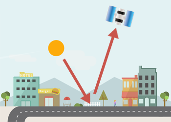
The sun emits electromagnetic energy (EM) in the direction of Earth.
The EM radiation that actually makes it to Earth is called incident energy (Ei). But some of this energy is also absorbed and scattered by gases and aerosols in the atmosphere before hitting the Earth’s surface.
If you only have a single image, atmospheric correction is only necessary if the image is very hazy. Normally all pixel values are influenced to the same degree and you can achieve good results with all standard classification methods.
Atmospheric correction removes the scattering and absorption effects from the atmosphere to obtain the surface reflectance characterizing (surface properties).
What are the methods for atmospheric correction?
Atmospheric modeling is perhaps the most sophisticated method to correct atmospheric disturbances.
Modeling approaches are ideal when scene-specific atmospheric data (aerosol content, etc.) are available. However, atmospheric information is rarely available.
For atmospheric correction, dark object subtraction is often recommended for classification and change detection applications
The dark object subtraction technique is the simplest and most used for image atmospheric correction. This method assumes the existence of zero or small surface reflectance. The minimum DN value in the histogram from an entire scene is subtracted from all pixels.
Radiative transfer models (LOWTRAN, MODTRAN) are also available to correct images.
Conclusion
Atmospheric correction removes the scattering and absorption effects from the atmosphere.
It obtains the surface characteristics.
Dark object subtraction, radiative transfer models, and atmospheric modeling are common techniques used to correct atmospheric disturbances.
Some satellite data are delivered as surface reflectance such as the Landsat Surface Reflectance products available on the USGS Earth Explorer.


1. Can I get an explanation of sensor and data properties?
2. What is meant by digital imagery?
It was very helpful thank you