Halloween Maps for the Dead
5 Halloween Maps. Almost all cultures recognize spirits aka the dead. So we bring these 5 maps for the dead to get you in the spirit of Halloween.
5 Halloween Maps. Almost all cultures recognize spirits aka the dead. So we bring these 5 maps for the dead to get you in the spirit of Halloween.

The best way to represent the Earth is with a globe. But map projections can be awfully useful too. Find out why cartographers use map projections in GIS.
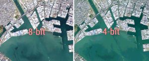
Bit depth is the amount of detail in each pixel expressed in units of bits. 1-bit rasters contain 2 values while 8-bit rasters range from 0-255

This guide is like your compass – these 33 mapping tips will guide you in the right direction and show you how to create stunning cartographic maps.

Maps help us get to places. They help us make decisions. Maps have changed how we think about location. But where did it begin? We study the history of GIS.
North American Datum of 1983 (NAD83) is 2-meters from geocentric and uses thousands of monuments with triangulation to create a reference frame for Earth
Deploying efficient raster GIS compression techniques means reducing storage space. It can save money, time and also help network performance.
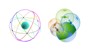
The World Geodetic System 1984 (WGS84) is a spatial reference system of GPS satellites with an error of less than 2 cm to the center of Earth.

So you want to geoprocess like a GIS guru, do you? From clipping to buffering, you will learn the basic GIS processing tools along with uses & applications