The Remarkable History of GIS

Where did GIS begin?
Mapping has revolutionized how we think about location. Maps are important decision-making tools. They help us get to places. And they are becoming more immersed in our everyday lives.
But where did it all begin?
Advancements in GIS were the result of several technologies. Databases, computer mapping, remote sensing, programming, geography, mathematics, computer-aided design, and computer science all played a key role in the development of GIS.
Today, we’ll uncover some of the key moments in the history of GIS that have shaped it into what it has become today.
Paper Mapping Analysis with Cholera Clusters

Dr. John Snow used mapping to illustrate how cases of cholera were centered around a water pump. Many people thought the disease was propagating through the air. However, this map helped show that cholera was being spread through the water.
The history of GIS all started in 1854. Cholera hit the city of London, England. British physician John Snow began mapping outbreak locations, roads, property boundaries, and water lines.
When he added these features to a map, something interesting happened:
He saw that Cholera cases were commonly found along the water line.
John Snow’s Cholera map was a major event connecting geography and public health safety. Not only was this the beginning of spatial analysis, but it also marked the start of a whole field of study: Epidemiology – the study of the spread of disease.
To this date, John Snow is known as the father of epidemiology. The work of John Snow demonstrated that GIS is a problem-solving tool. He put geographic layers on a paper map and made a life-saving discovery.
Stages of GIS Development
We can group the history of GIS into several stages of development.
If John Snow would have been alive today, those layers would have been stored in a database. He could’ve turned them on and off to visualize possible contamination causes. He could have even used spatial statistics to solve London’s problem.
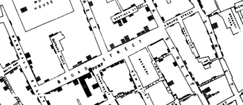
This is the original Cholera Map by John Snow which he used spatial analysis on paper maps to end the epidemic in London, England.
In the history of GIS:
We go from static paper maps to dynamic digital maps. Now, we go from basic analysis to more complex problem-solving.
When you compare John Snow in the past, to the present technology-savvy John Snow, you have to ask yourself one question: How has GIS developed into its current state?
The history of GIS is remarkable. It has gone through stages of development. It’s been influenced by key people and technology development.
We outline each stage in the history of GIS below.
Before 1960: The GIS Dark Ages

Computer mapping was in the dark. Nothing has been developed. All mapping was done on paper or sieve mapping. The technology wasn’t here for GIS to come to light.
In the 1950s, maps were simple. They had their place in vehicle routing, new development planning, and locating points of interest. But none of this was done on computers.
Imagine a world without computer mapping.
One option was sieve mapping. Sieve mapping uses transparent layers on light tables to identify areas of overlap. But this came with challenges: calculating areas was next to impossible, data was coarse and often inaccurate, and measuring distances was cumbersome.
With all the issues that came with paper maps, it was no surprise that cartographers and spatial users wanted to explore computing options for handling geographic data.
In the history of GIS, this was the main incentive to shift from paper to computer mapping.
1960 to 75: GIS Pioneering
The early 1960s to 1980s was really the time period of GIS pioneering.
The pieces were coming together with advancements in technology:
- Map graphics as outputs using line printers.
- Advances in data storage with mainframe computers.
- Recording coordinates as data input.
These initial developments in the world of computing are what propelled GIS to its next step forward. But what GIS really needed was a brilliant mind to put the puzzle pieces together.
Enter Roger Tomlinson – the father of GIS.
During Roger Tomlinson’s tenure with the Canadian government in the 1960s, he initiated, planned, and directed the development of the Canadian Geographic System (CGIS). This was a key time in the history of GIS because many consider CGIS as the roots of Geographic Information Systems. CGIS was unique because it adopted a layer approach system to map handling.

“Great discoveries and improvements invariably involve the cooperation of many minds. I may be given credit for having blaze the trail of GIS. But when I look at the subsequent development, I feel the credit is due to others rather than just myself.”
— Roger Tomlinson
Because of the vast amount of territory Canada occupies, the idea for a Canadian Land Inventory was developed in 1964. But it wasn’t until 1971 that it became fully operational.
The Canadian Land Inventory used soil, drainage, and climate characteristics to determine land capability for crop types and forested areas. It quickly recognized that accurate and relevant data was vital to land planning and decision-making. Over the years CGIS has been modified and improved to keep pace with technology.
GIS Pioneering – Around the World
The US Census Bureau was an early adopter of some of the core principles of GIS. It was the pioneering work by the US Census Bureau that led to the digital input of the 1970 Census using the data format GBF-DIME (Geographic Base File – Dual Independent Map Encoding).
GBF-DIME became a file format that supported digital data input, error fixing, and even choropleth mapping. Using this format, the US Census Bureau began to digitize Census boundaries, roads, and urban areas. This was a huge step forward in the history of GIS.
The Ordnance Survey in the UK also started their routine topographic map development. To this very date, the Ordnance Survey is still producing many different GIS data products including every house, every fence, and every stream in every single part of Great Britain.
At this point in the history of GIS, it was in its pioneering stage. It was still on its training wheels beginning to be fostered by only a select few national agencies around the world.
1975 to 90: GIS Software Commercialization

As governments realized the advantages of digital mapping, this influenced the work of the Harvard Laboratory Computer Graphics. In the mid-1970s, Harvard Laboratory Computer Graphics developed the first vector GIS called ODYSSEY GIS. Esri’s ARC/INFO used the technical framework from ODYSSEY GIS and this work led to the next stage of development in GIS – software commercialization.
In the late 1970s, memory size and graphics capabilities were improving. New computer cartography products included GIMMS (Geographic Information Making and Management Systems), MAPICS, SURFACE, GRID, IMGRID, GEOMAP, and MAP. In the late 1980s, there was an increasing range of GIS software vendors in this segment of GIS history.
One of these GIS software vendors was Esri – which is now the largest GIS software company in the world. In 1982, Esri launched ARC/INFO for minicomputers. Then in 1986, it released PC ARC/INFO for the Intel microcomputer. Esri is now the world’s leading expert in GIS software development and it has played a key role in the history of GIS.
At this point in the history of GIS, it also gained steam with some of the first conferences and published work. The first GIS meeting in the UK was in 1975. It included a small crowd of academics. The first Esri conference was in 1981 and attracted a crowd of 18 participants. GIS consultancies started sprouting. Roger Tomlinson first used the term “Geographic Information System” in his publication in 1968 “A Geographic Information System for Regional Planning”. That was a really lonely time for GIS.
But all of us users have made GIS what it is today. At the same time, Michel Paradis coined the term “Geomatics” in the 1980s as a unifying umbrella for today’s multi-disciplinary challenges.
READ MORE: Commercial GIS Software: List of Commercial Mapping Software
1990 to 2010: User Proliferation

Users are starting to adopt GIS technology in different ways. Classrooms, businesses, and governments around the world are starting to harness digital mapping and analysis.
All the ingredients were ready for the infiltration of GIS into society:
- Cheaper, faster, and more powerful computers
- Multiple software options and data availability
- The launch of new satellites and integration of remote sensing technology
1990 to 2010 was the period in the history of GIS when it really took off.
But advancements in technology have surpassed the average user. GIS users didn’t know how to take full advantage of GIS technology. Companies were hesitant to adopt GIS software. Countries didn’t have access to topographical data.
But over time, these issues were laid to rest.
Gradually, the importance of spatial analysis for decision-making was becoming recognized. Slowly, classrooms and companies started introducing GIS. The software was able to handle both vector and raster data. With more satellites in orbit, GIS systems can consume this data collected from space.
This in unison with the availability of global position systems gave users more tools than they’ve ever had before. Like the flick of a switch, the US government turned off GPS selective availability. Suddenly, accuracy has changed from the size of an airport to the size of a small shed. GPS has led the way for great innovative products like car navigation systems and unmanned aerial vehicles.
The floodgates for GIS and GPS developments began opening. This brings us to our next stage of development in the history of GIS: the open source explosion.
2010 to Onward: The Open Source Explosion
Processors are now in gigahertz. Graphics cards are crisper than they’ve ever been before. We now think of GIS data storage in terabytes. It’s no longer megabytes.
GIS data has become more ubiquitous. TIGER data, Landsat satellite imagery, and even LiDAR data are accessible to download for free. Online repositories like ArcGIS Online store massive amounts of spatial data. It’s a matter of quality control and fitting it for your needs.
The range of commercial GIS software products out there seems endless.
But what stands out is the big shift of GIS users building their own GIS software in an open, collaborative way. This software is available to the public and is completely open source. The big plus is that they are for public use at no cost.
Open source is becoming mainstream today. We are gradually entering an era of open source GIS software. More light is shining on QGIS than ever before. Even though, there will always be a place for commercial GIS software. Software companies like Esri provide solutions to practically any spatial problem that exists today. This includes areas such as artificial intelligence, data collection, and 3D analysis.
READ MORE: 13 Free GIS Software Options: Map the World in Open Source
GIS Past, Present, and Future
The history of GIS consists of 3 historic stages:
- Pioneering and development
- GIS software commercialization
- User adoption
As time went on, GIS became a computer-based tool for storing and manipulating map-based land data. It’s now a multi-billion dollar industry responsible for some of the most important decisions our Earth is facing.
What does the future hold for GIS? Real-time GIS? Augmented reality?
Every day, we are carrying the torch from the pioneers of GIS. We stand on the shoulders of giants. We are shaping the future of GIS. Companies, organizations, and governments adopt GIS because it’s a tool to help make knowledgeable decisions.
Today, we barely scratched the surface of the history of GIS. Read more on its remarkable history.
The Evolution of GIS in the 21st Century
Over the years, GIS has evolved from a mapping system to something much more than that. Generally, it has followed these key events shaping its path:
INFORMATION MANAGEMENT: Back in 2000, GIS evolved into a system of information management. For example, Esri developed its proprietary RDBMS geodatabase. This was a game-changer. Suddenly, the concept of topology and geometry correctness was fully integrated as early as 2002.
GEOGRAPHY: In 2006, GIS shifted focus. While data management still remained a strong point, more emphasis was placed on use cases. At this point, integration became a key area of interest. Through the various GIS applications and uses, this was the point where GIS became more mainstream.
GEODESIGN: It wasn’t until 2010, that the concept of geodesign became Esri’s primary vision. Geodesign rethinks how we inhabit the world, by combining geography with design. The main idea was that geodesign shapes our world by putting the needs of people at the forefront.
SCIENCE OF WHERE: Although geodesign, geography, and information management all remain pivotal concepts in GIS, the focus shifted to the integration of GIS with science in 2016. Simply, the “science of where” is what we do every day in GIS. It’s about pushing technologies into the boundaries of science and opening new possibilities.
INTELLIGENT NERVOUS SYSTEM: Finally, here is where we are now in 2020 and beyond. With the Internet of Things (IoT), the world is all connected in real-time. It’s about the evolution and the interconnection of technology between people and our planet. Geography is the glue that relates everything together.

“See what others can’t. We see patterns. Relationships. When you use location technology, you can see where things happen — before they happen”
— Jack Dangermond
Further Reading on the History of GIS
- The application of electronic computing methods and techniques to the storage, compilation, and assessment of mapped data. Roger Tomlinson (1974)
- The Invention of GIS. Harvard University Gazette (2011)


It’s good
I love this article!
I’m in college and this article was very well written. I just wish it was a little shorter. I go to Harvard so this article was a good reference.
Haha. No mention of Jack personally? Sorta avoiding the 800# elephant in the room, huh?
I have referenced it like this:
GISGeography. (2018, Feb 18). The Remarkable History of GIS. Retrieved from: https://gisgeography.com/history-of-gis/
Hope it helps :)
This is Wow. I also agree with Barbra, Kunmie and Jess. Author accreditation is Paramount.
Many lecturers do not subscribe to citing a web link, the name of editors/authors will be more appreciated, thanks.
you can cite is as following, it is also valid
Source: https://gisgeography.com/what-gis-geographic-information-systems/ accessed: 15.-02.2020
I’m also in academia. I am trying to cite this article, but really do need an author, editors, something. Please.
We are in academia. An author would be really appreciated.
Who wrote this? Very good article. I was hoping to reference it in a uni paper. Thanks
You can just reference the website as a whole – https://gisgeography.com