Acadia National Park Map
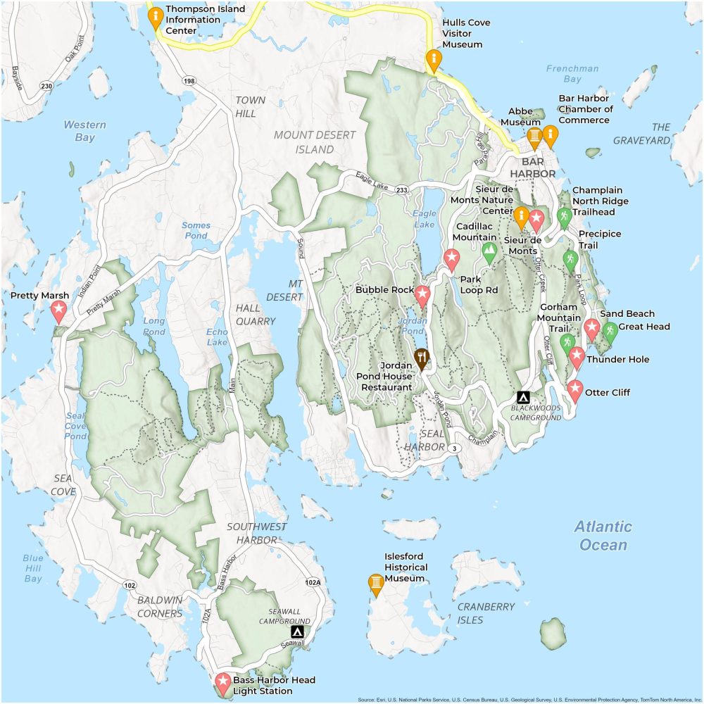
About the map
Discover the rugged beauty of Maine’s coast through our map of Acadia National Park. As you unfold this map, you’ll get to know the soaring peak of Cadillac Mountain and the diverse array of landscapes to explore in Acadia.
You’ll also familiarize yourself with the serene trails winding through dense forests and along rocky beaches. Whether you’re seeking a peaceful stroll along the Sieur de Monts or an adventurous hike up the Precipice Trail, this printable map is your guide to the sights and sounds of Acadia.
Use this map to navigate the highways, campgrounds, and ponds that make Acadia National Park the top national park in Maine. Locate the perfect spot for a picnic, find the best viewpoints for breathtaking sunsets, or plan a day of birdwatching or whale watching along the coast.
You are free to use our Acadia National Park map for educational and commercial uses. Attribution is required. How to attribute?
Top Things to Do
- Precipice Trail: A challenging, steep hike offering stunning views, known for its iron rung ladders.
- Bass Harbor Head Light Station: Iconic lighthouse with picturesque views.
- Thunder Hole: A natural inlet where waves create thunderous sounds; best at mid-tide.
- Bubble Rock: A precariously balanced boulder, accessed by a moderate hike.
- Cadillac Mountain: The highest point in the park, popular for sunrises and panoramic views.
- Jordan Pond: A serene, glacial pond known for clear waters and surrounding trails.
- Schoodic Peninsula: A less crowded area with a dramatic coastline, biking trails, and rugged terrain.
- Champlain North Ridge Trail: A moderate hike leading to views from Champlain Mountain.
- Sand Beach: A rare sandy beach in Maine tucked in between mountains and rocky shores.
- Otter Cliff: Dramatic cliffs with ocean views, popular for photography and sightseeing.
Discovery and Visitor Centers
Thompson Island Information Center
Hulls Cove Visitor Center
Sieur de Monts Nature Center
Rockefeller Welcome Center
Bar Harbor Chamber of Commerce
Campgrounds
Blackwoods Campground
Seawall Campground
Notable Places
Pretty Marsh
Mount Desert
Islesford Historical Museum
Jordan Pond House Restaurant
Town Hill
Southwest Harbor
Baldwin Corners
Seal Harbor
Cranberry Isles
Sea Cove
Mount Desert Island
Abbe Museum
Bar Harbor
Hall Quarry
Bays, Lakes and Ponds
Eagle Lake
Jordan Pond
Frenchman Bay
Echo Lake
Long Pond
Somes Pond
Western Bay
Seal Dove Pond
Blue Hill Bay
Atlantic Ocean
Highways and Roads
Maine State Route 3
Maine State Route 233
Eagle Lake Rd
Paradise Hill Rd
Park Loop Rd
Maine State Route 102
Champlain Dr
Seawall Rd
Bass Harbor Rd
Pretty Marsh Rd
References
- Acadia National Park (National Park Service)
- USGS Acadia National Park Map
- Topographic Maps of Acadia NP (USGS)
It is very interesting and I want know more