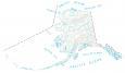
Alaska County Map
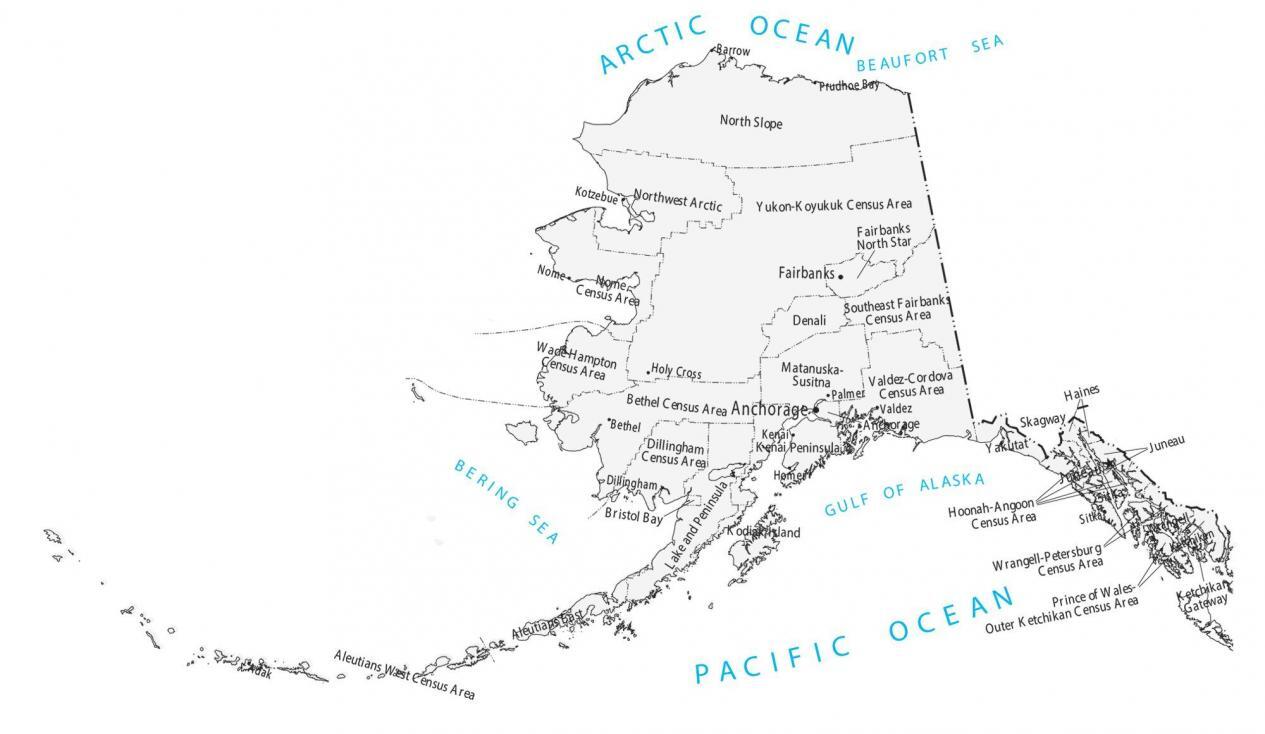
About the map
In terms of administrative boundaries, Alaska is completely unique because it doesn’t have counties. Instead, it consists of boroughs, census areas, cities, and municipalities.

Because land is so large and the population is sparse, boroughs act with an organized area-wide government. However, census areas don’t have an organized government and are for statistical purposes.
This Alaska county map displays all of its 29 administrative areas in total for the state of Alaska. In terms of population, Anchorage is the largest administrative boundary. Despite having one of the lowest populations, Yukon-Koyukuk has the largest area of any county or county-equivalent in the United States.
You are free to use our county map of Alaska for educational and commercial uses. Attribution is required. How to attribute?
Alaska map collection
Alabama boroughs, census areas, and municipalities list
| FIPS Code | Name | Land (sq mi) | Water (sq mi) | Population (2024) |
|---|---|---|---|---|
| 02-013 | Aleutians East Borough | 6985.0 | 8031.0 | 3,632 |
| 02-016 | Aleutians West Census Area | 4392.1 | 9724.3 | 5,424 |
| 02-020 | Anchorage Borough | 1706.4 | 237.6 | 289,600 |
| 02-050 | Bethel Census Area | 40628.9 | 4930.0 | 18,237 |
| 02-060 | Bristol Bay Borough | 482.0 | 366.7 | 884 |
| 02-063 | Chugach Census Area | 34221.7 | 6083.6 | 6,604 |
| 02-066 | Copper River Census Area | 34221.7 | 6083.6 | 2,631 |
| 02-068 | Denali Borough | 12636.9 | 25.5 | 1,621 |
| 02-070 | Dillingham Census Area | 18331.3 | 2297.6 | 4,642 |
| 02-090 | Fairbanks North Star Borough | 7329.5 | 105.4 | 94,951 |
| 02-100 | Haines Borough | 2339.6 | 405.8 | 2,104 |
| 02-105 | Hoonah-Angoon Census Area | 6556.6 | 3012.1 | 2,312 |
| 02-110 | Juneau City and Borough | 2703.9 | 550.8 | 31,572 |
| 02-122 | Kenai Peninsula Borough | 16023.2 | 8697.0 | 61,259 |
| 02-130 | Ketchikan Gateway Borough | 4856.9 | 1796.0 | 13,677 |
| 02-150 | Kodiak Island Borough | 6615.3 | 5469.8 | 12,654 |
| 02-158 | Kusilvak Census Area | 17073.8 | 2584.7 | 7,946 |
| 02-164 | Lake and Peninsula Borough | 23897.3 | 10035.6 | 1,315 |
| 02-170 | Matanuska-Susitna Borough | 24713.7 | 562.5 | 117,613 |
| 02-180 | Nome Census Area | 22971.9 | 5318.3 | 9,836 |
| 02-185 | North Slope Borough | 88824.0 | 6003.5 | 10,663 |
| 02-188 | Northwest Arctic Borough | 35648.3 | 4971.3 | 7,134 |
| 02-195 | Petersburg Borough | 2900.6 | 921.2 | 3,436 |
| 02-198 | Prince of Wales-Hyder Census Area | 5262.7 | 5646.7 | 5,746 |
| 02-220 | Sitka Borough | 2870.0 | 1945.1 | 8,355 |
| 02-230 | Skagway Borough | 433.9 | 11.1 | 1,119 |
| 02-240 | Southeast Fairbanks Census Area | 24822.7 | 290.3 | 7,313 |
| 02-275 | Wrangell City and Borough, Alaska | 2556.0 | 920.6 | 2,064 |
| 02-282 | Yakutat City and Borough, Alaska | 7623.2 | 1539.0 | 690 |
| 02-290 | Yukon-Koyukuk Census Area | 145573.2 | 2297.1 | 5,099 |
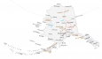
This Alaska map has at least two errors in it, possibly more. It claims to have been updated in August 2020, but it is out of date in several ways. The map shows “Skagway-Hoonah-Angoon Census Area”. That is ancient history; in 2007 Skagway was broken out of this group, leaving just the Hoonah-Angoon Census area (correct in your text, wrong on your map). Then, the text claims that Skagway is just a municipality. Wrong again: It is now a “City and Borough”, similar to Sitka, which your text classifies correctly.
Anchorage is also a City and Borough, although you don’t label it that way. And for some reason, you didn’t label either Ketchikan Gateway Borough or the Prince of Wales-Hyder Census Area at all on your “sub-maps”.
I think someone should spend a bit of time on the phone with folks in Juneau and clarify all this. Consistency, folks! :)
Good catch David.
– I fixed the large map to split Skagway from Hoonah-Angoon Census Area.
– In the smaller administrative map, I’ve fixed Skagway to show “City and Borough”
– It took me awhile to understand what you meant about the missing labels. But I can see you are referring to the mini administrative maps again. I’ve added the labels in there too.
Thanks again. I very much appreciate the feedback.