Arches National Park Map
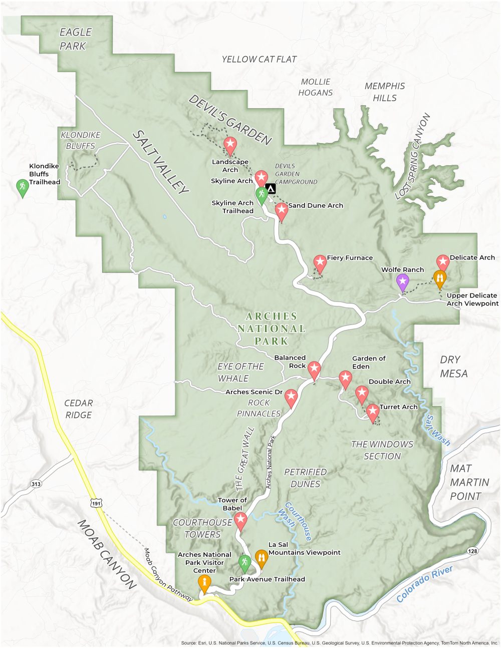
About the map
Embark on a journey in the heart of Utah’s red rock country with this Arches National Park Map. This map is your guide to campgrounds, trails, roads, visitor centers, and other points of interest of interest in eastern Utah.
The map of Arches National Park marks the park’s most iconic features. You’ll find the iconic Delicate Arch, a 52-foot-tall freestanding arch. Explore the Windows Section, where colossal sandstone formations frame the horizon.
For those who prefer the open road, we’ve outlined the park’s scenic drive. Whether you’re setting up camp at Devils Garden Campground or embarking on the Fiery Furnace hike, this Arches National Park Map opens up Arches National Park to you in all its glory.
You are free to use our Arches National Park map for educational and commercial uses. Attribution is required. How to attribute?
Top Things to Do
Check out our top recommendations for things to do at Arches National Park.
- Delicate Arch: Iconic, freestanding natural arch, a famous symbol of Utah and a popular hike destination.
- Double Arch: Two massive arches joined at one end, easily accessible and offering impressive photographic opportunities.
- Balanced Rock: A large, precarious boulder balanced on a slender pedestal, visible from the park road.
- Landscape Arch: One of the world’s longest natural arches, set in a remote landscape.
- Sand Dune Arch: Hidden between sandstone fins, it provides a sandy, shaded oasis with a small, climbable arch.
- Fiery Furnace: A maze of narrow sandstone canyons requiring a permit or ranger-led tour to explore.
- Turret Arch: A unique arch resembling a castle turret, often photographed with the North and South Windows.
- Broken Arch: A misleading name for a solid arch, accessible via an easy trail through beautiful scenery.
- Devils Garden: A hiking area with multiple arches, including Landscape Arch, and striking desert landscapes.
- La Sal Mountains Viewpoint: Offers panoramic views of the La Sal Mountains, contrasting with the red rock landscape.
Visitor Centers
Arches National Park Visitor Center
Campgrounds
Devil’s Garden Campground
Landforms and Places
Devil’s Garden
Salt Valley
Eye of the Whale
Rock Pinnacles
The Great Wall
Courthouse Towers
The Windows Section
Petrified Dunes
Moab Canyon
Cedar Ridge
Klondike Bluffs
Yellow Cat Flat
Memphis Hills
Lost Spring Canyon
Mollie Hogans
Dry Mesa
Mat Martin Point
Eagle Park
Salt Wash
Courthouse Wash
Colorado River
Trails
Park Avenue Trailhead
Skyline Arch Trailhead
Klondike Bluffs Trailhead
Other Features
Arches National Park Rd
Moab Canyon Pathway
Wolfe Road
Arches Scenic Dr
US 191
Upper Delicate Arch Viewpoint
References
- Arches National Park (National Park Service)
- USGS Arches National Park Map
- Topographic Maps of Arches NP (USGS)