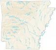
Arkansas County Map

About the map
This county map of Arkansas displays the 75 counties in Arkansas. Arkansas’ count of 75 counties represents the 18th highest out of any state in the United States.
The state capital, Little Rock, is in the most populated county of Pulaski. Pulaski County has just under 400,000 people and is located smack dab in the middle of Arkansas. Conversely, Calhoun County is the least populated county with about 5200 residents.
In terms of size, Union County in southern Arkansas is the largest. But Lafayette County occupies the smallest area at 545.1 square miles. Benton County holds the headquarters of Walmart in the city of Bentonville. Also notable, there is a county “Arkansas County” with the same name as the state.
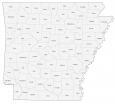

You are free to use our county map of Arkansas for educational and commercial uses. Attribution is required. How to attribute?
Arkansas county list
| FIPS Code | Name | Land (sq mi) | Water (sq mi) | Population (2024) |
|---|---|---|---|---|
| 05-001 | Arkansas County | 988.8 | 45.0 | 16,050 |
| 05-003 | Ashley County | 925.4 | 15.2 | 17,984 |
| 05-005 | Baxter County | 554.2 | 32.5 | 43,007 |
| 05-007 | Benton County | 847.6 | 36.4 | 321,566 |
| 05-009 | Boone County | 590.0 | 12.0 | 38,636 |
| 05-011 | Bradley County | 649.2 | 3.7 | 9,935 |
| 05-013 | Calhoun County | 628.6 | 3.8 | 4,690 |
| 05-015 | Carroll County | 630.0 | 8.7 | 28,968 |
| 05-017 | Chicot County | 644.3 | 46.5 | 9,272 |
| 05-019 | Clark County | 866.1 | 16.8 | 20,920 |
| 05-021 | Clay County | 639.5 | 2.0 | 14,112 |
| 05-023 | Cleburne County | 553.7 | 38.2 | 25,646 |
| 05-025 | Cleveland County | 597.8 | 1.0 | 7,367 |
| 05-027 | Columbia County | 766.0 | 0.8 | 22,024 |
| 05-029 | Conway County | 552.3 | 14.4 | 21,422 |
| 05-031 | Craighead County | 707.3 | 5.4 | 115,852 |
| 05-033 | Crawford County | 591.2 | 12.0 | 62,258 |
| 05-035 | Crittenden County | 610.3 | 26.0 | 46,633 |
| 05-037 | Cross County | 616.4 | 5.9 | 16,194 |
| 05-039 | Dallas County | 667.4 | 0.7 | 6,076 |
| 05-041 | Desha County | 768.1 | 51.4 | 10,321 |
| 05-043 | Drew County | 828.4 | 7.3 | 16,935 |
| 05-045 | Faulkner County | 647.9 | 16.1 | 131,611 |
| 05-047 | Franklin County | 608.8 | 10.8 | 17,586 |
| 05-049 | Fulton County | 618.2 | 2.1 | 12,546 |
| 05-051 | Garland County | 677.7 | 56.9 | 99,902 |
| 05-053 | Grant County | 631.8 | 1.1 | 18,546 |
| 05-055 | Greene County | 577.7 | 1.8 | 46,928 |
| 05-057 | Hempstead County | 727.5 | 13.7 | 19,105 |
| 05-059 | Hot Spring County | 615.2 | 7.0 | 33,313 |
| 05-061 | Howard County | 588.6 | 6.7 | 12,387 |
| 05-063 | Independence County | 764.0 | 7.6 | 38,345 |
| 05-065 | Izard County | 580.6 | 3.4 | 14,291 |
| 05-067 | Jackson County | 633.9 | 7.6 | 16,673 |
| 05-069 | Jefferson County | 870.0 | 43.8 | 63,672 |
| 05-071 | Johnson County | 659.9 | 22.9 | 26,172 |
| 05-073 | Lafayette County | 528.3 | 16.8 | 6,015 |
| 05-075 | Lawrence County | 587.6 | 4.7 | 16,305 |
| 05-077 | Lee County | 602.6 | 16.9 | 8,104 |
| 05-079 | Lincoln County | 561.6 | 10.6 | 12,868 |
| 05-081 | Little River County | 532.2 | 32.5 | 11,626 |
| 05-083 | Logan County | 708.1 | 23.4 | 21,457 |
| 05-085 | Lonoke County | 770.9 | 31.9 | 76,389 |
| 05-087 | Madison County | 834.3 | 2.8 | 17,865 |
| 05-089 | Marion County | 597.0 | 43.4 | 17,593 |
| 05-091 | Miller County | 625.7 | 11.9 | 41,958 |
| 05-093 | Mississippi County | 900.6 | 19.2 | 38,095 |
| 05-095 | Monroe County | 607.1 | 14.2 | 6,415 |
| 05-097 | Montgomery County | 779.9 | 20.4 | 8,510 |
| 05-099 | Nevada County | 617.8 | 2.8 | 8,004 |
| 05-101 | Newton County | 820.9 | 2.3 | 7,026 |
| 05-103 | Ouachita County | 732.8 | 7.0 | 21,684 |
| 05-105 | Perry County | 551.6 | 9.0 | 10,251 |
| 05-107 | Phillips County | 695.6 | 31.7 | 14,661 |
| 05-109 | Pike County | 600.6 | 13.5 | 10,027 |
| 05-111 | Poinsett County | 758.4 | 5.2 | 22,300 |
| 05-113 | Polk County | 857.7 | 4.8 | 19,434 |
| 05-115 | Pope County | 812.5 | 18.3 | 64,829 |
| 05-117 | Prairie County | 647.9 | 27.7 | 7,935 |
| 05-119 | Pulaski County | 758.9 | 48.7 | 401,209 |
| 05-121 | Randolph County | 652.2 | 3.8 | 19,040 |
| 05-125 | Saline County | 723.5 | 6.9 | 131,252 |
| 05-127 | Scott County | 892.3 | 5.7 | 9,837 |
| 05-129 | Searcy County | 666.1 | 2.4 | 7,836 |
| 05-131 | Sebastian County | 531.9 | 15.3 | 130,035 |
| 05-133 | Sevier County | 565.1 | 16.2 | 15,735 |
| 05-135 | Sharp County | 604.4 | 2.0 | 18,130 |
| 05-123 | St. Francis County | 634.8 | 7.7 | 21,822 |
| 05-137 | Stone County | 606.4 | 3.0 | 12,785 |
| 05-139 | Union County | 1039.2 | 16.0 | 37,008 |
| 05-141 | Van Buren County | 709.7 | 14.6 | 16,152 |
| 05-143 | Washington County | 942.0 | 10.4 | 266,184 |
| 05-145 | White County | 1035.1 | 7.1 | 79,091 |
| 05-147 | Woodruff County | 586.8 | 7.2 | 5,808 |
| 05-149 | Yell County | 930.1 | 18.7 | 20,134 |
I LOVE this. This makes school projects super easy.
Hiya GIS,
If you look at the pdf [Arkansas County Map – National Map] of your Arkansas county map, you’ll notice that it’s not quite the correct ‘A’ state. I’d love it if the correct Arkansas map were to be linked, found, uploaded, and posted. I looked at Arizona to see if someone was playing tricksy, but no such luck. Arkansas is lost.
We’re all lost, really, but those county lines are firm. Mostly.
Have a super weekend!
Thanks for catching that. I fixed the PDF link and it will now be the correct Arkansas County Map