Big Bend National Park Map
About the map
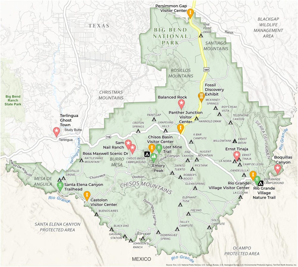
Our map of Big Bend National Park is your guide to exploring the “Desert Jewel of Texas”. It meticulously charts everything. From winding roads to remote campgrounds, we ensure you don’t miss a beat of Big Bend.
The map also points you toward other attractions. You’ll find Balanced Rock, a photogenic rock with the Big Bend landscape as a backdrop. Don’t forget the Fossil Discovery Exhibit, perfect for a rest after a day of exploration.
Let this map of Big Bend National Park be your guide as you plan your adventure. It shows you where to set up camp under the stars. With major roads, trails, and points of interest marked, your exploration of Big Bend National Park becomes a well-informed, enriching experience.
You are free to use our Big Bend National Park map for educational and commercial uses. Attribution is required. How to attribute?
Top Things to Do
Looking for the best things to do at Big Bend? Try these out.
- Lost Mine Trail: Scenic hike offering panoramic views, rich vegetation, and wildlife.
- Fossil Discovery Exhibit: Interactive exhibit showcasing Big Bend’s ancient fossils and geological history.
- Ross Maxwell Scenic Drive: Picturesque route highlighting Big Bend’s diverse landscapes and historic sites.
- Chisos Mountains: Isolated mountain range with stunning vistas, unique ecosystems, and hiking trails.
- Emory Peak: Tallest peak in Big Bend, offering challenging hikes and breathtaking views.
- Rio Grande Village Nature Trail: Easy, scenic trail with river views, birdwatching, and lush vegetation.
- Ernst Tinaja: A striking natural limestone formation and waterhole with unique rock layers.
- Boquillas Canyon: Majestic river canyon offering spectacular views, river access, and cultural significance.
- Sam Nail Ranch: Historic homestead site with a peaceful setting and diverse birdlife.
- Santa Elena Canyon Trail: Stunning trail along the Rio Grande, featuring dramatic canyon walls.
Discovery and Visitor Centers
Chisos Basin Visitor Center
Rio Grande Visitor Center
Panther Junction Visitor Center
Persimmon Gap Visitor Center
Castolon Visitor Center
Campgrounds
Chisos Basin Campground
Rio Grande Village Campground
Cottonwood Campground
Primitive Campsites
Black Dike Campsite
Buenos Aires Campsite
Camp de Leon Campsite
Candelilla Campsite
Croton Springs Campsite
Dominguez Spring Campsite
Elephant Tusk Campsite
Ernst Basin Campsite
Ernst Tinaja Campsite
Fresno Campsite
Glenn Spring Campsite
Grapevine Hills Campsite
Hannold Draw Campsite
Johnson’s Ranch Campsite
K-Bar Campsite
La Clocha Campsite
La Noria Campsite
Loop Camp Campsite
McKinney Springs Campsite
Nine Point Draw Campsite
Nugent Mountain Campsite
Ocotillo Grove Campsite
Paint Gap Campsite
Pine Canyon Campsite
Rattlesnake Mountain Campsite
Rice Tank Campsite
Robber’s Roost Campsite
Roy’s Peak Vista Campsite
Solis Campsite Campsite
Talley Campsite
Telephone Canyon Campsite
Terlingua Abajo Campsite
Willow Tank Campsite
Zapato Tuerto Campsite
Landforms/Physical Regions
Chisos Mountains
Sierra Del Carmen
Rosillos Mountains
Santiago Mountains
Rio Grande
Bura Mesa
Terlingua Creek
Mesa De Anguila
Christmas Mountains
Blackgap WMA
Ocampo Protected Area
Santa Elena Protected Area
Big Bend Ranch State Park
Other Features
Texas State Highway 118
Terlingua Ghost Town
Study Butte
Terlingua
Texas
References
- Big Bend National Park (National Park Service)
- USGS Big Bend National Park Map
- Topographic Maps of Big Bend NP (USGS)