Bryce Canyon National Park Map
About the map
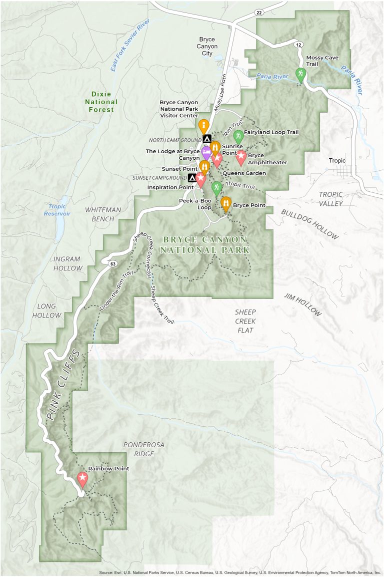
This Bryce Canyon National Park Map will help explore towering hoodoos and natural amphitheaters in southern Utah. This printable map is your compass to the campgrounds, observation points, and trails in the wonderland of red rock.
The Bryce Amphitheater, an area filled with the park’s most iconic hoodoos, is prominently featured on our map. Another highlight, Inspiration Point, offers breathtaking views that stretch across the amphitheater.
Our detailed map guides you to the park’s campgrounds and must-see sights, including North/Sunset Campground, the Lodge at Bryce Canyon, and its visitor center. Download this map of Bryce Canyon National Park and discover an out-of-this-world setting.
You are free to use our Bryce Canyon National Park map for educational and commercial uses. Attribution is required. How to attribute?
Top Things to Do
Get ready to explore Bryce Canyon National Park with this list of its top 10 attractions.
- Bryce Point: Renowned viewpoint offering expansive, breathtaking views of Bryce Canyon.
- Bryce Canyon Visitor Center: Starting point for park exploration, offering exhibits, information, and park ranger guidance.
- Navajo/Queens Garden Loop: Popular hiking trail combining stunning rock formations and accessible canyon exploration.
- Inspiration Point: Viewpoint with multi-level platforms for spectacular panoramic views of the canyon.
- Sunrise and Sunset Point: Iconic spots for watching the sunrise and sunset.
- The Lodge at Bryce Canyon: Historic lodge providing accommodation and dining with magnificent canyon views.
- Peek-a-Boo Loop: Challenging trail featuring close-up views of intricate hoodoo formations.
- Fairyland Loop: Scenic trail offering a less crowded, immersive experience in Bryce Canyon’s landscape.
- Bryce Amphitheater: The park’s most famous section, known for its dense concentration of intricate hoodoos.
- Rainbow Point: The highest viewpoint in the park, offering views of the entire park.
Visitor Centers
Bryce Canyon Visitor Center
Campgrounds
North Campground
Sunset Campground
*There are also primitive campsites not shown on the map.
Trails
Rim Trail
Tropic Trail
Fairyland Loop Trail
Peek-a-Boo Loop Trail
Under the Rim Trail
Sheep Creek Trail
Mossy Cave Trail
Landforms, Places and Other Features
Pink Cliffs
Ingram Hollow
Dixie National Forest
Whiteman Bench
Long Hollow
Heep Creek Flat
Jim Hollow
Ponderosa Ridge
Bulldog Hollow
Tropic Valley
Bryce Canyon City
East Fork Sevier River
Tropic Reservoir
Paria River
Highway 63
Mossy Cave
References
- Bryce Canyon National Park (National Park Service)
- USGS Bryce Canyon National Park Map
- Topographic Maps of Bryce Canyon NP (USGS)