Map of Houston, Texas

Map of Houston
Explore the largest city in the state of Texas and the fourth-largest in the United States. We feature a Houston map with roads/highways, reference information, and things to do. If you want to really scout out the city, check out our interactive map below.
There are so many exciting adventures to be discovered in the great City of Houston. From museums, to live music and great food, you’ll find some superb attractions to visit in this hub of Texas. But how will you ever find them all? Except through a map, right?
Houston is an amazing city full of culture, diversity, and opportunity. Plus, it’s home to NASA! It has a lot to offer its residents and visitors. So map out your next adventure while you’re in town with our easy-to-use collection of printable maps of Houston, Texas.
Jump To: Interactive Map | Printable Road Map | 10 Things to Do | Reference Map
Houston map collection
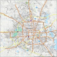
Interactive Map of Houston
This is one of the only maps you’ll ever need to plan your trip to Houston, Texas. You can explore the city with this interactive map or use it to see what attractions are near you. With this map, you can explore the city and discover things to do, places to eat, and more. Explore Houston and all the attractions and hot spots in the city with this interactive map.
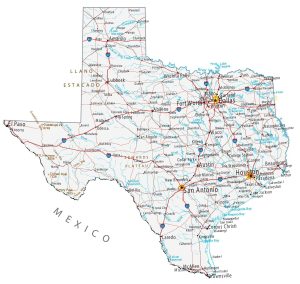
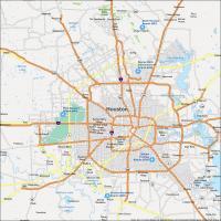
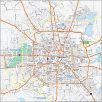
Houston Road Map
Houston is a large city, so it can be difficult to know where to go. With the ability to explore Houston with this map, you can relieve some of the stress. This Houston road map is perfect for navigation and for finding your way around the city. At a glance, you can find interstates, highways, and major roads. You will find this printable map is perfect for exploring the city of Houston and it will keep you informed on your journey. But for travel outside the city, take a look at our Texas road map that’s also available for free.

Interstate Highways: I-10, I-45, I-610
US Highways: 35, 59, 90, 99, 225, 249, 288, 290, Beltway 8, Beaumont Hwy, Katy Fwy, Jesse Jones Beltway 8 Toll Bridge
Parkways/Freeways: Allen Pky, Eastex Fwy, Eldridge Pky, Fort Bend Pky, La Porte Fwy, North Fwy, Northwest Fwy, Saint Joseph Pky, Sam Houston Pky, Will Clayton Pky
Major Roads: Blodgett St, Fannin St, Fm 1093 Rd, Hardy Toll Rd, Kirby Dr, Main St, Mount Houston Rd, Old Spanish Trl, Reveille St, Telephone Rd, Westpark Dr
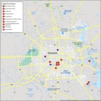
10 Things To Do in Houston
With so many interesting places to explore, you’ll want to make the most of your visit to Houston. This map will help you find the best places to visit in Houston Texas. You can use this map for a day out or weekend away, or your next business trip. Discover the best of Houston with a convenient and easy-to-use map. This map is a must-have for any Houston visitor. It’s perfect for planning your day and finding hidden gems along your travels.
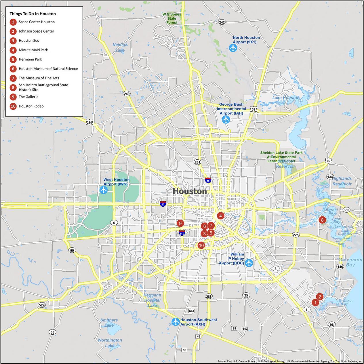
Houston is the largest city in Texas. It’s also home to NASA and the Johnson Space Center. If you ever decide to go to Houston, we recommend from our list of 10 things to do.
- Space Center Houston
- Johnson Space Center
- Houston Zoo
- Minute Maid Park
- Hermann Park
- Houston Museum of Natural Science
- The Museum of Fine Arts
- San Jacinto Battleground State Historic Site
- The Galleria
- Houston Rodeo
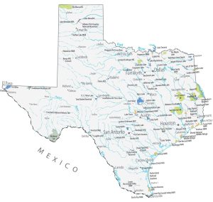
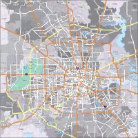
Houston Reference Map
Houston is a large city, so it can be difficult to know where to go. Explore Houston with this map so you can relieve some of the stress of traveling. It’s an exciting city that offers a variety of things to do. Follow this map to explore parks, villages, and things to do and see in Houston. We created this reference map that tells you all about what you can do and see around the city. You can use the map to explore Houston, Texas, and discover some of the most fascinating and beautiful sights in the area. Dive into the city of Houston and see what it has to offer.

Airports: William P. Hobby Airport (HOU), Houston George Bush Intercontinental Airport (IAH)
Towns: Stagecoach, Thompsons, Woodloch
Villages: Fairchilds, Iowa Colony, Pleak
Census-designated place (CDP): Aldine, Atascocita, Bacliff, Barrett, Channelview, Cinco Ranch, Cloverleaf, Crosby, Cumings, Fifth Street, Four Corners, Fresno, Highlands, Mission Bend, Pecan Grove, Pinehurst, Porter Heights, Sheldon, Sienna Plantation, Spring, The Woodlands
Cities: Alvin, Arcola, Baytown, Beasley, Bellaire, Brookshire, Brookside Village, Bunker Hill Village, Clear Lake Shores, Conroe, Dayton, Deer Park, Dickinson, El Lago, Friendswood, Fulshear, Galena Park, Hedwig Village, Hilshire Village, Houston, Humble, Hunters Creek Village, Jacinto City, Jersey Village, Katy, Kemah, La Marque, La Porte, League City, Magnolia, Manvel, Meadows Place, Missouri City, Morgan’s Point, Nassau Bay, Needville, Oak Ridge North, Pasadena, Pattison, Patton Village, Pearland, Piney Point Village, Plum Grove, Richmond, Roman Forest, Rosenberg, Sandy Point, Santa Fe, Seabrook, Shenandoah, Shoreacres, South Houston, Southside Place, Splendora, Spring Valley Village, Stafford, Sugar Land, Taylor Lake Village, Texas City, Todd Mission, Tomball, Waller, Webster, West University Place, Weston Lakes, Woodbranch