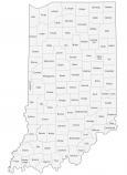
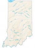
Indiana County Map

About the map
This Indiana county map displays its 92 counties. The number of counties in Indiana ranks as the 12th highest in the United States. The most populated county in Indiana is Marion because it holds the state capital of Indianapolis.
In fact, it’s so populated that it’s almost in the top 50 for the highest population in all of the United States. Other major counties in Indiana include Lake, Allen, and Hamilton County for the highest population, each with 300,000+ people.
In terms of area, Allen County is the largest with a size of about 660 square miles. But Ohio County is the smallest county occupying an area of just 87.2 square miles. This small county of Ohio is next to Switzerland County. Interestingly, its name originated because of its early Swiss settlers


You are free to use our county map of Indiana for educational and commercial uses. Attribution is required. How to attribute?
Indiana county list
| FIPS Code | Name | Land (sq mi) | Water (sq mi) | Population (2024) |
|---|---|---|---|---|
| 18-001 | Adams County | 339.0 | 0.9 | 36,584 |
| 18-003 | Allen County | 657.3 | 2.7 | 399,295 |
| 18-005 | Bartholomew County | 406.9 | 2.6 | 84,741 |
| 18-007 | Benton County | 406.4 | 0.1 | 8,853 |
| 18-009 | Blackford County | 165.1 | 0.5 | 11,816 |
| 18-011 | Boone County | 422.9 | 0.3 | 78,773 |
| 18-013 | Brown County | 312.0 | 4.6 | 15,650 |
| 18-015 | Carroll County | 372.2 | 2.8 | 20,747 |
| 18-017 | Cass County | 412.2 | 2.7 | 37,559 |
| 18-019 | Clark County | 372.8 | 3.6 | 127,479 |
| 18-021 | Clay County | 357.6 | 2.7 | 26,424 |
| 18-023 | Clinton County | 405.1 | 0.2 | 32,895 |
| 18-025 | Crawford County | 305.6 | 3.1 | 10,523 |
| 18-027 | Daviess County | 429.5 | 7.4 | 34,097 |
| 18-029 | Dearborn County | 305.1 | 2.3 | 51,435 |
| 18-031 | Decatur County | 372.6 | 0.8 | 26,421 |
| 18-033 | DeKalb County | 362.8 | 1.0 | 44,330 |
| 18-035 | Delaware County | 392.1 | 3.8 | 112,951 |
| 18-037 | Dubois County | 427.3 | 8.1 | 43,629 |
| 18-039 | Elkhart County | 463.2 | 4.8 | 207,436 |
| 18-041 | Fayette County | 215.0 | 0.1 | 23,335 |
| 18-043 | Floyd County | 148.0 | 1.0 | 81,931 |
| 18-045 | Fountain County | 395.7 | 2.2 | 16,833 |
| 18-047 | Franklin County | 384.4 | 6.6 | 23,136 |
| 18-049 | Fulton County | 368.4 | 2.9 | 20,004 |
| 18-051 | Gibson County | 487.4 | 11.7 | 33,038 |
| 18-053 | Grant County | 414.1 | 0.8 | 66,458 |
| 18-055 | Greene County | 542.5 | 3.4 | 31,219 |
| 18-057 | Hamilton County | 394.3 | 8.1 | 379,704 |
| 18-059 | Hancock County | 306.0 | 1.1 | 88,810 |
| 18-061 | Harrison County | 484.5 | 2.0 | 39,978 |
| 18-063 | Hendricks County | 406.9 | 1.9 | 190,629 |
| 18-065 | Henry County | 391.9 | 3.0 | 49,081 |
| 18-067 | Howard County | 293.0 | 0.9 | 84,082 |
| 18-069 | Huntington County | 382.6 | 5.1 | 36,944 |
| 18-071 | Jackson County | 510.0 | 3.9 | 47,420 |
| 18-073 | Jasper County | 559.6 | 1.8 | 33,387 |
| 18-075 | Jay County | 383.9 | 0.2 | 20,164 |
| 18-077 | Jefferson County | 360.6 | 2.3 | 32,921 |
| 18-079 | Jennings County | 376.6 | 1.8 | 27,634 |
| 18-081 | Johnson County | 320.4 | 1.3 | 170,614 |
| 18-083 | Knox County | 516.0 | 8.0 | 35,872 |
| 18-085 | Kosciusko County | 531.4 | 23.0 | 80,669 |
| 18-087 | LaGrange County | 379.6 | 7.1 | 41,122 |
| 18-089 | Lake County | 498.8 | 127.8 | 502,955 |
| 18-091 | LaPorte County | 598.3 | 15.0 | 111,348 |
| 18-093 | Lawrence County | 449.2 | 2.8 | 45,192 |
| 18-095 | Madison County | 451.9 | 1.0 | 134,222 |
| 18-097 | Marion County | 396.4 | 6.6 | 981,628 |
| 18-099 | Marshall County | 443.6 | 6.1 | 46,464 |
| 18-101 | Martin County | 335.8 | 4.6 | 9,864 |
| 18-103 | Miami County | 373.8 | 3.5 | 35,613 |
| 18-105 | Monroe County | 394.5 | 16.8 | 140,702 |
| 18-107 | Montgomery County | 504.6 | 0.8 | 38,633 |
| 18-109 | Morgan County | 403.8 | 5.6 | 73,825 |
| 18-111 | Newton County | 401.8 | 1.7 | 14,131 |
| 18-113 | Noble County | 410.8 | 6.6 | 47,811 |
| 18-115 | Ohio County | 86.1 | 1.3 | 5,996 |
| 18-117 | Orange County | 398.4 | 9.8 | 19,824 |
| 18-119 | Owen County | 385.3 | 2.5 | 21,851 |
| 18-121 | Parke County | 444.7 | 5.3 | 16,508 |
| 18-123 | Perry County | 381.7 | 4.6 | 19,320 |
| 18-125 | Pike County | 334.3 | 6.8 | 12,116 |
| 18-127 | Porter County | 418.1 | 103.7 | 175,860 |
| 18-129 | Posey County | 409.4 | 10.0 | 25,067 |
| 18-131 | Pulaski County | 433.7 | 0.9 | 12,421 |
| 18-133 | Putnam County | 480.5 | 2.2 | 37,804 |
| 18-135 | Randolph County | 452.4 | 0.9 | 24,337 |
| 18-137 | Ripley County | 446.4 | 1.6 | 29,214 |
| 18-139 | Rush County | 408.1 | 0.3 | 16,759 |
| 18-141 | St. Joseph County | 457.9 | 3.5 | 273,744 |
| 18-143 | Scott County | 190.4 | 2.4 | 24,751 |
| 18-145 | Shelby County | 411.1 | 1.6 | 45,654 |
| 18-147 | Spencer County | 396.8 | 4.7 | 20,192 |
| 18-149 | Starke County | 309.1 | 3.1 | 23,463 |
| 18-151 | Steuben County | 308.8 | 13.7 | 34,862 |
| 18-153 | Sullivan County | 447.2 | 6.9 | 20,768 |
| 18-155 | Switzerland County | 220.7 | 2.8 | 9,988 |
| 18-157 | Tippecanoe County | 498.9 | 4.3 | 191,650 |
| 18-159 | Tipton County | 260.5 | 0.0 | 15,324 |
| 18-161 | Union County | 161.2 | 4.0 | 6,884 |
| 18-163 | Vanderburgh County | 233.7 | 3.0 | 180,387 |
| 18-165 | Vermillion County | 256.9 | 3.0 | 15,516 |
| 18-167 | Vigo County | 403.5 | 6.9 | 106,166 |
| 18-169 | Wabash County | 412.5 | 8.4 | 30,777 |
| 18-171 | Warren County | 364.7 | 1.7 | 8,451 |
| 18-173 | Warrick County | 384.8 | 6.2 | 66,339 |
| 18-175 | Washington County | 513.7 | 2.9 | 28,345 |
| 18-177 | Wayne County | 401.7 | 2.6 | 66,410 |
| 18-179 | Wells County | 368.1 | 2.2 | 28,798 |
| 18-181 | White County | 505.1 | 3.6 | 24,833 |
| 18-183 | Whitley County | 335.6 | 2.3 | 34,885 |