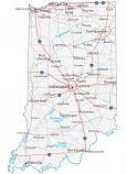
Map of Indiana – Cities and Roads

About the map
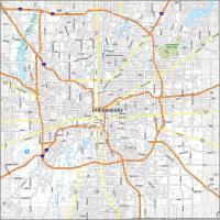
This Indiana map contains cities, towns, highways, roads, rivers, and lakes in the state of Indiana. For example, Indianapolis, Fort Wayne, and Evansville are major cities shown on this map of Indiana.
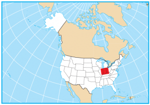
Indiana claims the birthplace of Michael Jackson in Gary, Indiana. Indianapolis, the capital city of Indiana, is home to the Indianapolis 500 car racing. Indiana is a Great Lakes state with Lake Michigan situated to the north. It also neighbors Illinois, Kentucky, Ohio, and Michigan.
Indiana’s nickname is the “Crossroads of America” because six interstate highways travel through it. But its lesser-known nickname is the “Hoosier State”. This nickname is based on the Indiana Pacers and the Hoosiers college basketball team.
Indiana map collection


You are free to use our map of Indiana for educational and commercial uses. Attribution is required. How to attribute?
State capital
Indianapolis
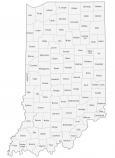
Major cities and towns
Indianapolis
Evansville
Fort Wayne
Gary
South Bend
Anderson
Bloomington
Carmel
Columbus
Elkhart
Fishers
Goshen
Greenwood
Hammond
Jeffersonville
Kokomo
Lafayette
Lawrence
Marion
Michigan City
Muncie
New Albany
Richmond
Terre Haute
Valparaiso
West Lafayette
Noblesville
Portage
Angola
Auburn
Bedford
Crawfordsville
Elwood
Frankfort
Franklin
Greencastle
Greensburg
Huntington
Jasper
La Porte
Logansport
Madison
Martinsville
Peru
Plymouth
Princeton
Seymour
Shelbyville
Shoals
Wabash
Warsaw
Washington
Vincennes
Linton
Rochester
Decatur
Interstate highways
Interstate-64 (I-64)
Interstate-65 (I-65)
Interstate-69 (I-69)
Interstate-70 (I-70)
Interstate-74 (I-74)
Interstate-80 (I-80)
Interstate-90 (I-90)
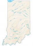
Lakes, rivers and creeks
Wabash River
White River
Ohio River
Tippecanoe River
Monroe Lake
Patoka Lake
Ah yes, Indianapolis. where the Lucas Oil Stadium stands for the Bands of America hold their competition. Last year, the American Fork High School Marching band went to finals and scored 8th in the nation. That is a core memory that has stuck with me to this day.
I suck at chess dude, can’t do this daily puzzle.
My brother-in-law was born in Indiana (do not know the city) and we are celebrating his 100th birthday this month in Texas. I have been searching for an appropriate gift and I found information on the mint in Silver Towne, Winchester, Indiana. I have a few silver bars from that mint, but I cannot locate Winchester on any state map. Can you help me? I know he will be interested in any information we can find on his home state and the origin of the silver. I want to give him the silver bars with the notes about the mint during his birthday party. He is a World War II veteran, served over 20 years in the U.S. Army and is a genuine hero (although he denies that). Thank you for anything of interest we can use.
I would like use this map please
Sure thing, we allow you to use it with a citation
The description of the state, Indianapolis (Naptown—50 years out of date), and why it is called the “Hoosier” state are inaccurate. Please have someone who knows the state author a new, accurate copy. Thank you.