Mammoth Cave National Park Map
About the map
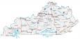
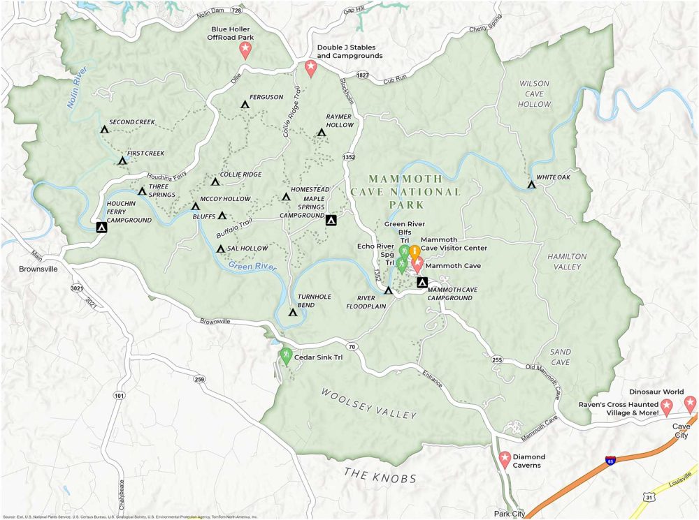
Get to know the world’s longest cave system with this Mammoth Cave National Park Map. Located in the heart of Kentucky, this printable map is your guide to the campgrounds, visitor centers, trails, and attractions of this national park.
Immerse yourself in the park’s natural environment. The campgrounds, including the Mammoth Cave Campground and the Houchin Ferry Campground, offer perfect settings for nights under the stars. Take a look at the primitive campsites too on this map.
You’ll find attractions like the Green River Ferry and the scenic Echo River Springs. Each brings the beauty of the park’s diverse ecology to light. Download our free printable map of Mammoth Cave National Park as your trusty sidekick.
You are free to use our Mammoth Cave National Park map for educational and commercial uses. Attribution is required. How to attribute?
Top Things to Do
Find our list of the best things to do in Mammoth Cave National Park below.
- Mammoth Cave: World’s longest cave system with unique tours through vast subterranean rooms and tight passages.
- Diamond Caverns: Features beautiful formations and illuminated underground rooms.
- Double J Stables and Campgrounds: Horseback riding and camping experience near Mammoth Cave, suitable for all ages.
- Echo River Spring Trail: Scenic trail in Mammoth Cave Park, leading to a beautiful spring and cave entrance.
- Dinosaur World: Outdoor dinosaur-themed park with life-sized models, fossil digging, and educational exhibits.
- Mammoth Cave Visitor Center: Main information hub for the park with exhibits, tour tickets, and park details.
- Blue Holler OffRoad Park: Adventure park offering off-road trails for ATVs, UTVs, and dirt bikes.
- Green River Bluffs Trail: Scenic trail offering views of the Green River and diverse ecosystems in Mammoth Cave National Park.
- Raven’s Cross Haunted Village: A themed attraction offering a haunted village experience with historical and spooky elements.
- Cedar Sink Trail: Unique trail featuring geological formations, sinkholes, and a seasonal waterfall in Mammoth Cave National Park.
Visitor Centers
Mammoth Cave Visitor Center
Campgrounds
Mammoth Cave Campground
Houchin Ferry Campground
Maple Springs Campground
Campsites
Second Creek Campsite
First Creek Campsite
Three Springs Campsite
Ferguson Campsite
Collie Ridge Campsite
McCoy Hollow Campsite
Bluffs Campsite
Sal Hollow Campsite
Turnhole Bend Campsite
River Floodplain Campsite
Raymer Hollow Campsite
Homestead Campsite
White Oak Campsite
Trails
Echo River Spring Trail
Green River Bluffs Trail
Cedar Sink Trail
Buffalo Trail
Collie Ridge Trail
Landforms and Rivers
Woolsey Valley
The Knobs
Collie Ridge
Wilson Cave Hollow
Hamilton Valley
Sand Cave
Green River
Nolin River
Highways and Roads
Scenic Route 70
State Hwy 1352
Kentucky Route 255 (KY-255)
Old Mammoth Cave Rd
Stockholm Rd
Houchin’s Ferry Rd
Ollie Rd
Cub Run Rd
Brownsville Rd
Mammoth Cave Rd
Nolin Dam Rd
Places
Brownsville
Park City
Cave City
References
- Mammoth Cave National Park (National Park Service)
- USGS Mammoth Cave National Park Map
- Topographic Maps of Mammoth Cave NP (USGS)