Redwood National Park Map
About the map
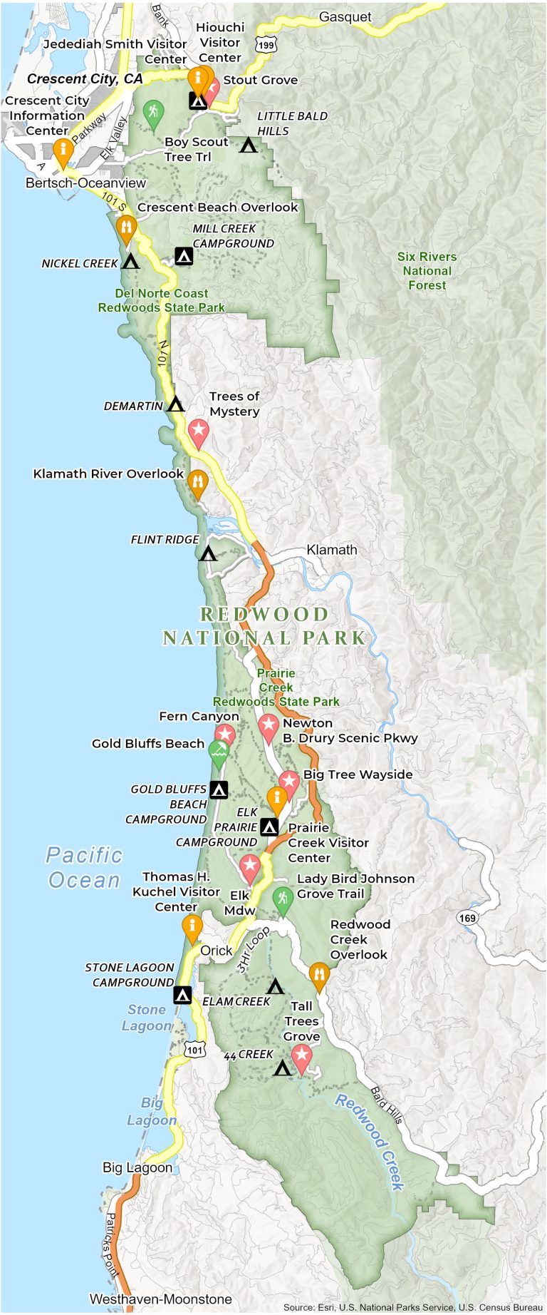
Embark on a journey through a world dominated by the tallest trees on Earth. Our Redwood National Park Map reveals campgrounds, trails, roads, visitor centers, attractions, and much more.
Highlighted on the map are must-visit spots like the awe-inspiring Fern Canyon and the Lady Bird Johnson Grove. You’ll also find campgrounds like Elk Prairie and Gold Bluffs Beach which provide serene retreats under starlit skies.
The map details visitor centers, including the Thomas H. Kuchel Visitor Center. Roads like the Newton B. Drury Scenic Parkway cut through the heart of the forest, offering a drive among giants. Download and use this as your map to Redwood National Park.
You are free to use our Redwood National Park map for educational and commercial uses. Attribution is required. How to attribute?
Top Things to Do
Find our list of the best things to do in Mammoth Cave National Park below.
- Lady Bird Johnson Grove: Tranquil redwood grove dedicated to conservationist Lady Bird Johnson.
- Stout Grove: Serene redwood grove that is known for its immense, ancient trees.
- Fern Canyon: Lush, verdant canyon walls densely covered in ferns, offering a unique hiking experience.
- Newton B. Drury Scenic Parkway: Scenic drive through old-growth redwoods in Prairie Creek Redwoods State Park.
- Gold Bluffs Beach: Secluded beachfront with golden sands, part of Prairie Creek Redwoods State Park.
- Crescent Beach Overlook: Scenic viewpoint offering panoramic views of Crescent Beach and the Pacific Ocean.
- Avenue of the Giants: Iconic 31-mile scenic highway surrounded by towering redwood trees.
- Klamath River Overlook: Dramatic viewpoint overlooking the Klamath River as it meets the Pacific Ocean.
- Trees of Mystery: Tourist attraction with unique tree formations and a gondola ride through redwoods.
- Big Tree Wayside: Home to an impressive, easily accessible large redwood tree.
Visitor Centers
Hiouchi Visitor Center
Jedediah Smith Visitor Center
Crescent City Information Center
Prairie Creek Visitor Center
Thomas H. Kuchel Visitor Center
Campgrounds
Jedediah Smith Campground
Mill Creek Campground
Gold Bluffs Beach Campground
Elk Prairie Campground
Stone Lagoon Campground
Campsites
Little Balls Hills Campsite
Nickel Creek Campsite
Demartin Campsite
Flint Ridge Campsite
Elam Creek Campsite
44 Creek Campsite
Parks and Forests
Prairie Creek Redwoods State Park
Six Rivers National Forest
Del Norte Coast Redwoods State Park
Water
Big Lagoon
Stone Lagoon
Redwood Creek
Monterey Bay
Pacific Ocean
Populated Places
Crescent City
Gasquet
Westhaven-Moonstone
Big Lagoon
Bertsch-Oceanview
Orick
Other Landmarks
US-101
Tall Trees Grove
Redwood Creek Overlook
Boy Scout Tree Trail
Elk Meadow