Thermal Infrared Sensor (TIRS) on Landsat
Landsat’s Thermal Infrared Sensor (TIRS) measures the Earth’s surface temperature by focusing on the infrared part of the light spectrum.

Landsat’s Thermal Infrared Sensor (TIRS) measures the Earth’s surface temperature by focusing on the infrared part of the light spectrum.

While traditional images are taken from directly above, oblique imagery captures them at an angle. Learn more about oblique images.

What if we could use sound to explore underwater? Sonar does just that. Simply, sonar turns sound waves into a map of the ocean floor.

A CubeSat is a miniaturized satellite roughly the size of a Rubik’s cube. They’re small enough to hold in your hand and inexpensive to build.

Aerial photography is a type of photography in which you capture images that are distant, from “in the air” using drones, satellites, and more.

Spatial resolution is how detailed objects are in an image based on pixels. But spectral resolution is the amount of spectral detail in a band.
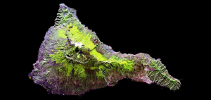
Synthetic Aperture Radar (SAR) is an emerging technology in remote sensing with the advantage to see in any weather condition and even at night.

Hyperspectral imaging takes a spectrum of light and divides the light into hundreds of narrow spectral bands. For example, Hyperion has 242 bands at 30m GSD.

As our population grows and climate is at risk, remote sensing of the environment solves large-scale environmental issues for the land, ocean and atmosphere.

A polar orbit satellite travels pole-to-pole. For a sun-synchronous orbit, it passes over any given point on Earth’s surface at the same local solar time.