Yosemite National Park Map
About the map
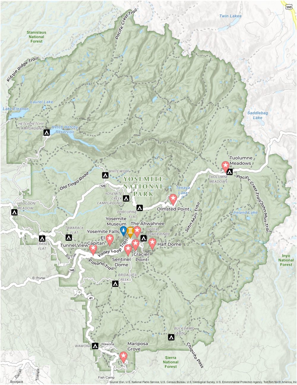
Begin your adventure in the heart of the wilderness with our map of Yosemite National Park. This map is the perfect companion for exploring the beauty of one of America’s most beloved natural treasures in the state of California.
Our free map highlights the park’s most famous landmarks. It includes the awe-inspiring El Capitan, the breathtaking Half Dome, and the mesmerizing Yosemite Falls.
People come to Yosemite to walk along trails that twist through the massive, ancient giant sequoias. That’s why our map of Yosemite National Park includes trails, and other features like highways, campgrounds, lakes, and more.
You are free to use our Yosemite National Park map for educational and commercial uses. Attribution is required. How to attribute?
Top 10 Things to Do
Cross these off your bucket list! Here are the top 10 things to do in Yosemite National Park, according to us.
- Half Dome: A famous granite dome in Yosemite, known for its unique shape. It’s a popular spot for hikers with great views from the top.
- El Capitan: A massive granite monolith standing about 3,000 feet from base to summit. It’s challenging even for rock climbers.
- Yosemite Falls: One of the tallest waterfalls in North America and a spectacular sight, especially in spring.
- Tunnel View: One of the most famous views of Yosemite Valley, including El Capitan, Half Dome, and Bridalveil Fall.
- The Ahwahnee: A historic hotel known for offering luxury accommodation in the park.
- Glacier Point: An overlook with views of Yosemite Valley, Half Dome, and the High Sierra.
- Sentinel Dome: A granite dome offering panoramic views of the park, including El Capitan and Yosemite Falls.
- Tuolumne Meadows: A gentle, dome-studded subalpine meadow area in the high country.
- Yosemite Museum: Provides exhibits on the natural and cultural history of the park, including Native American heritage and the park’s geological history.
- Mariposa Grove: This grove is the largest of the sequoia groves in Yosemite.
Visitor Centers and Museums
Yosemite Valley Welcome Center
Yosemite Exploration Center
Valley Wilderness Center
Yosemite Museum
Happy Isles Art and Nature Center
Campgrounds
Upper/Lower Pines Campground
North Pines Campground
Wawona Campground
Bridalveil Creek Campground
Hodgdon Meadow Campground
Crane Flat Campground
Tamarack Flat Campground
White Wolf Campground
Yosemite Creek Campground
Porcupine Flat Campground
Tuolumne Meadows Campground
Trails
Valley Loop Trail
Pohono Trail
Old Tioga Road Trail
Pacific Crest Trail
Kibbie Ridge Trail
Pacific Crest Trai
John Muir Trail
Chiquito Pass
Landforms/Physical Regions
Sierra National Forest
Tenaya Lake
Ireland Lake
Hetch Hetchy Reservoir
Olmsted Point
Stanislaus National Forest
Inyo National Forest
Laurel Lake
Lake Eleanor
Twin Lakes
Towns and Populated Places
Bootjack
Wawona
El Portal
Buck Camp Cabin
Fish Camp
Highways and Roads
Highway 140
US Highway 41
Big Oak Flat Rd
Highway 120
References
- Yosemite National Park (National Park Service)
- USGS Yosemite National Park Map
- Topographic Maps of Yosemite NP (USGS)