GIS Certification: Is It Worth It?

What kind of GIS certification is available?
The three primary GIS certification types are the GIS Professional (GISP), Esri Technical certifications, and local GIS certification.
But is it worth your time, effort, and money to be GIS-certified?
Well, you’ve come to the right place because we show you step-by-step the programs available for GIS certification.
And best of all: Is it worth it to enroll in a GIS certificate program? Let’s dive right in.
Types of GIS certificates
The three primary GIS certifications that employers seek and the major differences are:
| Certification Type | Requirements |
|---|---|
| 1. Geographic Information Systems Professional (GISP) | Must pass an exam and fulfill requirements for work and volunteer experience. |
| 2. Esri Technical Certification | Knowledge and test-based with Esri-related technology and products. |
| 3. Local College or University GIS Certification | Learn from university and industry leaders while building proficiency working with Esri ArcGIS Software. |
Now, let’s look at the three types of GIS certifications in a bit more detail.
1. GISP Certification
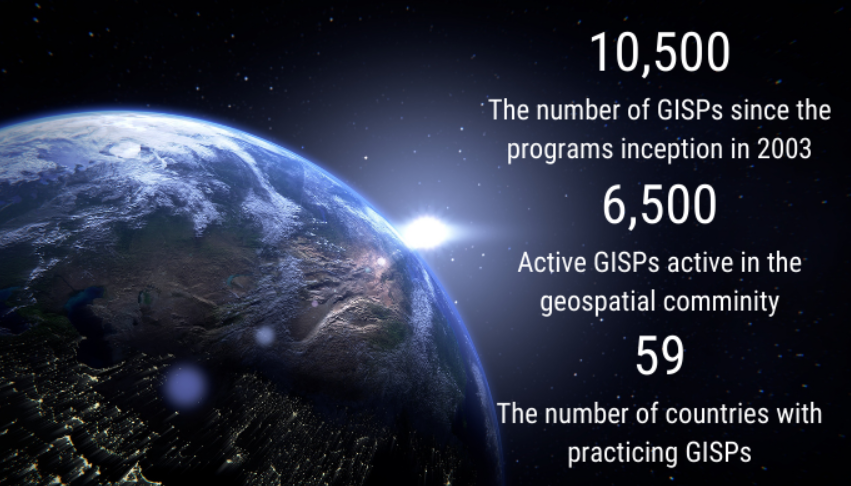
If you want a career in GIS, GISP is probably the most recognized type of GIS certification. According to the GIS Certification Institute (GISCI), there are 10,500 individuals certified with a GISP designation throughout the world. Although the number may vary at this time, GISCI previously listed 5,500 individuals as active members.
The GISP application manual highlights all the requirements for attaining this GIS certification. For example, you need to meet the experience, education, and contribution requirements to be GISP certified.
- EXPERIENCE: You need at least 4 years of full-time experience in the field of GIS.
- EDUCATION: Before you send your application, you need to meet the education requirements.
- CONTRIBUTIONS: It also looks at how many contributions you have made to the GIS community. For example, this could be anything from presentations, journal articles and volunteering.
- EXAMINATION: Lastly, you have to pass the GISCI Geospatial Core Technical Knowledge Exam.
You will also have to provide a fee and proof that you fulfilled these criteria. If you fulfill the requirements listed, you will become fully certified as a GISP. Once you earn your GISP, it’s valid for a three-year period. This means that you need to re-certify after this period is over.
2. Esri Technical Certification
The Esri Technical Certificate is a relatively new program. Unlike GISP which focuses on experience and involvement, the Esri Technical Certification is completely knowledge-focused and exam-based.
There are four levels where you can attain GIS certification:
- Foundation: Basic skills, 0-2 years of experience.
- Associate: Developing skills, 2-4 years of experience.
- Professional: Proficient skills, 4+ years of experience.
- Specialized: Has a focus on specific topics or software.
If you are interested in the Esri Technical Certificate programs, be sure to look at the beta exams to help prepare.
If you don’t want to commit to this certification, there is also Esri’s free training and MOOC to boost your skillset. My only complaint about Esri certification is that it’s specific to their products and it doesn’t really teach you anything outside the box.

3. Local GIS Certification
Sometimes, it’s best to go local. Because at the end of the day, it’s these local connections that become most valuable after you graduate. Plus, employers will recognize the institute you graduated from.
Being close means better access to relevant resources and chances to collaborate. Each can help you pave the way for a successful career in GIS.
So, choosing a nearby university for GIS studies has its perks. You’ll have easier access to local projects and potential job opportunities through networking.
Is it worth it to be GIS certified?
I guess this is the big question, isn’t it? Is it worth the time, money, and effort to be local, GISP, or Esri certified? Put a different way, can the cost of getting educated to a professional level on the GIS market be worth the knowledge?
It really depends.
Nowadays, it’s rare to see any type of GIS certification as a requirement in a job description. For the surveyor profession, it is often essential to certify yourself and is a job requirement. But in the case of GIS, many employers are less familiar with the GISP and Esri Technical certificates. If the company uses another GIS software, that means your time, money, and effort for Esri certification was wasted.
But there’s a lot to get out of GIS certifications though. For example:
- It can help you differentiate yourself when applying for a crowded GIS position. Not to mention, the extra credentials may push you one spot ahead of other candidates.
- GIS certification helps you become an expert in your field and gives you confidence.
- Lastly, you get the necessary experience and knowledge to climb the GIS career ladder in your job.
Overall, GIS certification is a major opportunity for job seekers who want to advance their careers as geospatial professionals. Once completed, you can showcase these skills to future employers. So overall, it depends on how much you think the GIS certification will benefit you and what you want to get out of it.


The GISP is a differentiator in the field of GIS. GISP holders are recognized as expert, full-time GIS practitioners rather than a part time dabblers or those whose primary discipline is geology, engineering, CAD, etc and use GIS intermittently in support of their work. A GISP can be expected to be competent in handling all aspects of GIS work, cartography, data management, team management, project management, BD, webGIS, enterprise GIS, scope and budget development, etc.
A new GISP will have successfully completed a portfolio review, which requires 4-5 years of professional experience and passed an exam. The exam is no joke, it is a difficult, software agnostic test that approaches the subject academically and covers a diverse range of topics relevant to the science and practice of GIS. It is not as in-depth as the PE or PG exams, but the level of difficulty has significantly increased the perception of the GISP as a certification of an individual’s abilities as a GIS professional. If GIS is your career choice, then a GISP is a necessity.
I am a graduate of BS Information Technology in 2014 and started working on the May 2015. In January 2016, I was designated as GIS Personnel doing GIS related task. From there, My knowledge and skill in GIS grew, but my IT related skills and knowledge were not. Now I realized that I was on a different path from the course where I graduated. Now I decided to pursue this path and grew more on this field for a good cause. And now I am finding and selecting cautiously the resources to use for me to advance since I have limited time and money. I hope someone would guide me..
I recently finished a Graduate Certificate in Geospatial Intelligence Analytics (GEOINT) and I couldn’t have been more disappointed with the program, content quality, instructors and university. I already had a graduate level educational background and wanted to improve GIS skills so I understand what good education is and isn’t. Little to no teaching involved in an attempt to “automate” classes online. Weeks went by with no grading or feedback on assignments. Most workflows can be YouTubed, and I have taken free Coursera course with quality much higher. Pay thousands and thousands of dollars for it. Sure, I got another great looking certificate/piece of paper. Says a lot about the state of the US educational system. I would not recommend GEOINT or anything related to the USGIF.
Indeed certification in GIS is good but mostly in the private sector.
Unless the industry you’re pitching for uses QGIS, which is rare in the US, go with the ESRI certification GISP exists just for the money they collect. ESRI is $250, very reasonable on-time only fee and it’s ESRI, what else can I say. Go for it.
A GISP is useful mostly in the private sector to make yourself stand out. I’ve only seen a few jobs mention it as recommended, and almost none require it. Even most government RFP’S rarely mention it unless the client is knowledgeable about GIS in general. While there are some Government employees that have it, the incentive isn’t there to the same degree since they usually have job security if they stay in one place.
I was a GISP for 8 years, until they changed the pricing model. My employer used my GISP when bidding on jobs, so I think it is worth it if your company pays for it. Otherwise, not so sure. As long as you are competent in your interview, and keeping up on any free courses you can take on your own, you will be fine. I do agree with the guy above who said the industry doesn’t pay correctly anyway. I worked from 2002-2015 in GIS. I managed groups and everything. The most I got paid was 60k, and that was after I asked for a raise, didn’t get it, left and came back when clients were asking where I went and said the subsequent service they got was bad. If employers paid more for your certification/expertise, sure. Instead I self taught myself Python and SQL, did that for a couple years and now I am a full time DBA. My point is, the GISP won’t help you get ahead on it’s own. If you are gonna put energy into something, learn development or some other special skill that will put you ahead of other GIS Techs.
I’ve been in the industry for over 20 years, mostly as an imagery interpreter. I remember the merger of the Defense Mapping Agency (DMA) and the National Photographic Intelligence Center (NPIC) into the National Imagery and Mapping Agency (NIMA) then evolve into the National Geospatial Agency (NGA). I hold several certifications in geographic intelligence (GEOINT), a bachelors of science in GIS and currently working on my graduate degree, created countless produces in support of real-time combat operations and exercise support throughout the world. I have had the pleasure of serving with my sister services at joint and allied commands. Now I have to prove to a potential employer that I know my job by having a GISP after my name. I AM a GISP. I’ve volunteered 21 years of my life to the protection of this nation as a GEOINT professional and have an extensive body of work and numerous accolades both as military member and civilian contractor. In short what can I GISP me beyond a hand shake and a cup of coffee?
Please where do I get past questions and answers for GISP exams to help prepare,thank u
Are there any expedited courses or advanced level course to get through the program faster?
How about if I already have an AAS Degree in AutoCAD Drafting in the same field and also required along with the GIS when applying for jobs?
AAS Degree in Drafting AutoCAD, Engineering and Design
AAS Degree in Business
Does the AutoCAD Drafting Degree lessen the load of courses required for the GIS
I have completed Bachelors in Architecture from india recently and planning to do a GIS course from Canada, which particular GIS course should I go for and certified from ESRI or GISP.. Pls help me out here
You will need a minimum of 4 years experience for a GISP so you’re only option would be the Esri certifications
I was wondering what the best online schools are for a certificate for the money and time. Someone told me I could take a 3 wk course but I am not really sure where they were talking about?
I believe that GISP and ESRI certifications are a farce. Yes, I actually said it. I could not get GISP certification BECAUSE I did not have community service hours because I did not take time off from my work that pays the bill to teach students for free. I did not pass my ESRI technical certification exam and was told that I lack basic fundamentals in GIS despite being in industry for 15+ years prior to taking the test. I did not pass BECAUSE most of the questions were webgis/ArcGIS portal/sharing and caring stuff. Nothing to do with ArcGIS or ArcCatalog or knowledge of geography (in which I have a degree in from ivy league school). Only couple of ArcGIS questions that were actually asked dealt with what drop down list says on what random tool most people never use. How am I supposed to know what checking a box on Getisorg tool does if I have not had to touch the darn thing in 15 years? You can’t learn what you do not use on the daily and even if you want to learn, you have to figure out on your own because most companies do not have every extension purchased. I had questions on Hazmat and networking and schematics. I do not have any of those available to me.
Here is a fact: It is easy to sell people idea of what they need. It is easy to sell employers an idea of what they should be looking for. And then there is reality. Every time I go to ESRI conventions and look at deer in the headlights GISP professionals asking basic 101 level questions or programmers who never even touched ArcMap or so called GIS certificate people who paid $1000 to learn the software without having a basic understanding of geography struggling to grasp why water flows down hill….
It is all mostly a farce. It will continue being a farce for as long as GIS careers continue paying low wages and not recognized as significant and for as long as other careers dabble in it and call themselves experts and for as long as it is possible to get GIS certificates without having a degree in geography and for as long as certification process caters to “sharing data” (ie government agencies using web gis).
Most of us in the private world never get to share and if we do, it is a shapefile or a database feature class, maybe a layer file or something… hardly ever well polished online portal thing because sharing is not what we do and you can be a 30 year GIS professional doing GIS 10 hours per day and still fail exam because you do not know webgis or ineligible for GISP because you don’t volunteer.
Employers do not magically say: “Ohh well Susie has a GISP… we need to give her a $10,000 pay raise”. No… all GIS jobs pay pittance in comparison to what it costs to get a degree in the field and ceiling for GIS jobs is pretty low too. Sure programmers get paid more but they are programmers, not GIS professionals.
I know people in logistics using arcmap without knowing how to use arcmap. I know people in land management and compliance using arcmap without knowing how to use it. I know people in engineering screwing things up profusely because they believe they know how to use GIS.
And then there is reality in which people who know do not get paid all that much and employers refusing to pay adequately.
Tampa Bay GIS salaries pay $38-57,000 for government and $45-58,000 for education sector and $38-68,000 for private. (High numbers are after 20 years on the job).
VERY insightful and helpful in my decision whether to pursue this cert. Thank you for your honest insight.
Interesting article. At first glance, It seems that most of the certifications are designed for someone with a degree in a GIS related field, or at least for someone with a professional degree. I am curious about certification programs for the non-professional and where someone might start in this field.
Did you know there is an Esri Technical Certification space in GeoNet? This is where the certification team posts specific information about the program. For those of you that have specific education-focused questions, there is also an Education space where you could ask your questions. Here is the link to learn more about GeoNet and the Education space – https://community.esri.com/community/education
I always had an interest in Cartography, and have a long career in graphic design. I would like to start a career using GIS but I’m unsure if I should take an online GIS certification program through UCI, Univ. of Michigan or Michigan State University, (or another university) or pursue a Masters degree in GIS. I have a bachelors in Art with a minor in Computer Science. Does anyone have a suggestion for my desire for some type of education in GIS and what kind of job I could strive for after completing the classes? And what the pay scale might be? I have over 30 years of experience in design and would like to change fields.
I think a Bachelors in Art and minor in computer science are two great complimenting subjects for specializing in cartography/GIS. As for salary expectations, we have put together an infographic with payscale ranges – https://gisgeography.com/gis-salary-expectations-gis-career/
There’s a lot to consider between a Masters program and GIS certification. Maybe, some of the people on here can chime in to help
I don’t agree with getting certified unless you do not have a background in GIS with professional experience or if you are starting a GIS business doing freelance work. Getting certified does not guarantee you a job or guarantee you’ll be the selected candidate. If you go to a 4 year accredited college or university for GIS, that is your certification and you become a professional when you gained experience. I don’t see the cost outweighing the benefits.
Hello, I had my BTech in Transport management (Aviation major) and I’m thinking of getting my masters degree in GIS(a professional masters). I don’t know if I’m on the right part. Pls I need your advice. Though, I intend getting another masters degree in international Aviation management(when I can afford it)
GIS certification is vital. For the industry, more so the private sector, getting work, contracts and all other related tasks, might require a certification. This should be the first thing to pocket before venturing into any business in the GIS field.
Again it depends with your interests and career. Technical knowledge is different from non-technical knowledge and requires different levels of understanding. It’s always good to gauge yourself and analyse the need for this certification.
Hello all….excuse me if my comment is irrelevant….. I participated in the ESRI technical exam about two months ago and passed this exam…. Now I want to know if it’s possible to order my certificate?? If yes, how???
I’m finishing up my last few assignments in NC State University’s GIS graduate certificate program. This is also an excellent program. NC State offers a graduate certificate, MS, and PhD degrees in GIS for any that are interested. All courses for the graduate certificate are available online, but you’d have to ask about the MS and PhD programs. If so inclined you could probably couple it with our College of Engineering’s Computer Science programs as well.
I am in my last semester at Fanshawe College (ontario) in the online GIS graduate certificate program. If anyone is looking into this program it is great! I really learnt a lot of skills that will be helpful to land a job!
I have a secondary social studies and history degree but am wanting to get out of teaching. I am really interested in GIS and found a certificate program at University of Michigan for it. I was wondering if the certificate program would help me obtain a job in the GIS field or if I’d have to pursue a second bachelors degree.
I personally think that a GIS certificate would help you get a job in the industry. Here are some more tips for a career in GIS. https://gisgeography.com/gis-career-job/
Just wondering is there good GIS & CADD Integration Certificate program in the U.S.? I have a GIS Bachelor degree but am looking for to enhance my qualification with CADD. Thank you.
i completed a GIS certificate at a regional community college. Halfway through the program, the department decided it was going to discontinue the program due to decreasing enrollment in the classes offered. There was one instructor teaching all the required classes, he had done so for a few years prior to my enrollment. (Side note: He was a professional GIS analyst–academically and professionally–and worked for the city planning dept.).
In the middle of my 5 certificate courses, the program was suspended without a formal announcement to the students and the instructor. This caused lots of confusion among the students committed to the program. Finally, it was communicated that the program was going to resume with the remaining students, numbering 2-4 at this point. I paid in full for the last two courses, but despite my commitment to completing the program and assuming the college would do right by the students and instructor, the final three courses were a waste of time and money. The instructor was not being treated well by the administration by not processing his course materials on time, etc. By the time I completed the final “courses,” all concerned were frustrated and ripped off.
I got an online GIS certificate on my own accord to improve my job skills since GIS has become an integral part of my job. Since this program didn’t provide the instruction or training one expects from a $600/credit hour institution, I don’t even emphasize my GIS certificate as part of my resume because, if asked to produce such products on the job, I don’t feel like I could without some serious review and having to take basic courses over again. To compound this problem, my bosses haven’t tasked me with GIS responsibilities on the job and I haven’t used the few skills I have learned.
In the meantime, I am looking or a job that requires more GIS skills and I intend to take basic GIS courses online, as many free ones as possible since I blew my tuition budget already.
Be wary of online certificate degree programs. Colleges want your money. I am not convinced that they are that dedicated to providing the training and education to students that they initially claim.
Research online programs wisely.
I took a course at college, GIS and Remote Sensing, mostly introductory. I loved it and now I want to pursue a career in the field. I have a BS in Geology. I was looking up GIS certificate courses near me and found one offered by San Francisco State University. Should I go for it?
Are there any other courses I should take? I read that Cartography would be a great course to take. Any sort of advice will be appreciated. Thank You.
I think that GIS and geology would compliment each other very well. Particularly, the oil and gas industry hire people with these types of skills. I discuss some of the geology and GIS applications in this article (419-434) – https://gisgeography.com/gis-applications-uses/
I have entered into a certificate GSA/GIS program at a college and was wondering if this is a waste of money? Someone told me I could get certified online much cheaper. I assume the general science classes would help me in the job market? I am signed up to take intro earth science and aerial photography this fall
I have worked in CAD for a manufacturing company for several years. I have an A.A.S. in CAD. There seems to be some connections with GIS and CAD. I feel like I would only get half value out of some of my classes, is that safe to say? Is it common to just get on the job training?
Thanks for any advice
It depends for a lot of these questions.
I don’t think a GIS certificate is a waste of money. There are some employers who want to see this on a CV and occasionally candidates can be filtered out if they don’t have one. With that said, I think Earth Sciences and aerial photography are 2 great courses and skills to learn. If you decide to get out of the GIS certificate program entirely, you can list that you’ve taken these 2 courses on your CV.
I personally think there are more CAD jobs available (at least North America). I’d agree that there’s a connection between CAD and GIS and having these two areas of proficiency is a bonus. Can you get on-the-job training? Yes, you could. But it’s a matter of getting your foot in the door. Tailor your CV to match the job specification for each job posting. It’s a lot of work but HR (who doesn’t know much about GIS) will filter those candidates out if they don’t see those specific keywords.
My personal opinion is to learn as much as you can. Get to know as many people as possible in your CAD and GIS communities. Because sometimes it’s about who you know, not ‘what’ you know
I think that it is important to note that the GISP now requires one to ALSO take a 172 question exam that ranges from geomorphology, high level statistcal analysis, HTML programming, geodetics and photogrammetry. They have only gone through two testing cycles to date. Further more they test on a “core knowledge” not the platform. This means that there is tons of variablity in the answers. All GIS professionals know that there is more than one way to skin a cat but the way that they have designed their exam is that there is only one way to skin a cat and its the way they want it. This makes it very difficult to answer multiple choice questions.
Interesting article. Certification in GIS is one of my hot topic issues. There are actually a lot more than two GIS related certifications. You have professional certification such as the GISP from GISCI and GIS Technologist from ASPRS. Then you have Technical Certifications such as Esri’s and AutoDesk’s. The difference between these is wide but basically the Professional level certifications indicate an overall knowledge and capability level outside of a specific software or platform where as the technical level is focused on a specific software. The two are not mutually exclusive. Based on surveys I have conducted in 2013 and 2014, certification is still not widely accepted by the GIS industry. Education and experience are the primary keys to getting job. However it does appear the certifications are gaining a foot hold and are slowly growing in acceptance.
eGIS Associates