GIS Salary Expectations: Climb the GIS Career Ladder
GIS salary and pay scale expectations
What is the typical GIS salary? What are the highest-paying GIS jobs? How much money can you make in GIS?
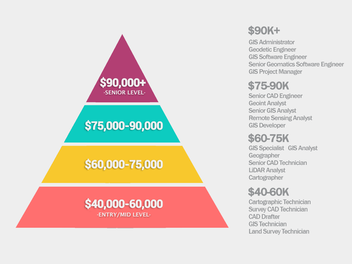
GIS is a diverse field. It’s diverse in pay scale too with the average GIS salary ranging from $40,000 to over $100,000+.
This is why we’ve outlined GIS salary ranges in a pyramid infographic.
Let’s get started.
Low-end GIS salary careers (40,000$-60,000$)
The field of geomatics brings a range of career options. At the lower end of the pay scale, technicians and draftsmen typically earn the least.
These positions are tasked with grunt work and the focus is to learn GIS. For example, they often involve basic roles in databases, analysis, and mapping. Editing data and writing metadata also play big roles in these types of careers.
But don’t let the pay scale fool you though. GIS technicians, draftsmen, and analysts do all the heavy lifting for project workloads. Without them, there wouldn’t be a solid foundation for data.
- Cartographic Technician ($42,000)
- Survey CAD Technician ($44,000)
- CAD Drafter ($45,000)
- GIS Technician ($48,000)
- Land Survey Technician ($53,000)
Mid-range GIS salary careers (60,000$-80,000$)

As we move higher in the salary range, we see more specialized skilled professions. For example, remote sensing and LiDAR analysts are in the mid-range pay scale range.
GIS administrators have managerial roles for large enterprise databases. Not only do they design spatial database infrastructure. But they are responsible for backup and recovery too.
Finally, we start to see senior positions such as geodesists and engineering roles. These positions need years of experience and often extra certification.
- Geographer ($61,000)
- GIS Specialist ($64,000)
- GIS Analyst ($65,000)
- Senior CAD Technician ($70,000)
- LiDAR Analyst ($71,000)
- Cartographer ($75,000)
- Senior CAD Engineer ($75,000)
- Senior GIS Analyst ($76,000)
High-end GIS salary careers (>80,000$)

Senior GIS positions are at the top of the salary list. For example, GIS project managers plan, execute, and close projects. Education and experience are why these positions dominate the top of the GIS pay scale.
Senior geomatics software engineers need the right education to design, develop, and maintain software. This GIS career requires the right skill set to write code and GIS programming. Finally, GIS developers are also in high-end GIS salary careers.
- Remote Sensing Analyst ($83,000)
- GEOINT Analyst ($83,000)
- GIS Developer ($85,000)
- GIS Administrator ($96,000)
- Geodetic Engineer ($98,000)
- GIS Software Engineer ($99,000)
- Senior Geomatics Software Engineer ($103,000)
- GIS Project Manager ($105,000)
Do you want to pursue a GIS career?
If you’re thinking about pursuing a career in GIS, it can be very fulfilling. For example, it’s a high-tech job that’s changing every moment.
In this GIS salary guide, we give the market rate for a variety of geomatics positions. But if you just want to get your foot in the door, we have a couple of ways that can help.
- 10 GIS Career Tips to Help Find a GIS Job
- How To Think Outside the Box For GIS Jobs
- GIS Certification: Is It Worth It?
Did we miss any GIS careers? Please let us know in the comments.
References
Salary Information (2022, February 11). Retrieved from ZipRecruiter and Indeed.


When will we see another update? The field has seen some recent changes in the past 2 years regarding responsibilities and salary.
Hi Becca. Hoping to provide another update in 2025. Thanks for checking in!
Thanks so much for taking my comment under advisement and updating the salaries for this, it’s great to have this resource updated!
It’s extremely disappointing that you’re still using the same salary ranges as you were in 2016 (I have that exact same pyramid graphic saved on my computer from that year). While this post was a good source six years ago, I now find it concerning that it is being “updated” for 2022 without actually addressing how salaries have increased since your original publication.
Thanks, I appreciate the heads up. And yes, the salary information was in desperate need of an update. That’s why I updated all salaries and put them all into new tiers.
Most GIS salaries received a bump up in earnings. But strangely, I think the career “geographer” was a bit too high in the last list of salaries. This is the only one that had a significant movement downwards.
Also, I should mention that the “Update for 2022” could be anything related to the post. I don’t have a “changelog” or anything like that in our posts. But the update was related to something different (not salary information). But now, this should be all updated.
Anyways, I hope you enjoy it, and thanks for reading!
It should be noted the factors behind your salary go beyond your raw technical skill level. It has more to do with the funding source of your organization. For example, if you are working local government the odds are your going to get paid less than in State or Federal due to the relatively small amount of tax revenue they can pull in. That means a GIS Manager job there might be much lower compared to somebody with the Feds or an intelligence organization.
A contractor with the Federal government is a different matter altogether. Let’s say you work with a low overhead small business that’s a prime on a contract. They may pay you much more than you could ever make working even for the Federal Government. On the other hand, if you work for your typical big business as a contractor, you may get just a little more than industry average due to higher overhead. At the end of the day it’s up to what you want: security in one place, or the challenge of moving in different places and getting exposed to different projects. Sometimes if you stick to security you’ll get just that, and a significant pay cut over the years.
I am agree with Roger Cottrell’s opinion.
GIS in archaeology is a great opportunity.
GIS will be the next big thing in archaeology. The future of archaeology will use mainly GIS for mapping the ground and analyze possibilities for future successful excavation.
Has anyone paired GIS with archaeology? There seems to be many developing applications of digital data sets in the field of archaeology (e.g., LiDAR, photogrammetry). I’m wondering if any readers here are applying GIS within the field of archaeology and have any advice on pursuing it.
@ Marc The GIS field is a fickle one to say the least. Over the last several years the industry has been saturated with people seeking ways to make their mark in this field. I currently contract for the government; personally enjoy this particular path as I work to finish off my MGIST. For me though, I have over 16 years in the military as an imagery analyst and have the educational backing to secure a salary at the top end of the spectrum. Essentially I can fill the role of an imagery analyst or geospatial analyst; they are cousins in the industry, but quite different in reality.
The private sector is full of opportunities as virtually every company in every industry uses GIS in some shape or form. If money is what you (or anyone) seek; the GIS programming/developing and Geospatial Scientists and Statisticians (those “big data” positions)
tend to pull the higher salaries from what I have seen.
I have found its years of experience and technology that drive these salaries. GIS is just a tool. It can be applied to mapping utilities, Biology, IT, etc. However, you have to push ahead. I have been in the GIS world full time for 4 years and part time for 13. I have found equally that privately learning through ESRI is about the same as an Associates Degree. The employers are looking for skills and years of experience. A 20 year career should land you a role as supporting the applications and maps that new Drafters will make. Don’t get discouraged. We have an online social media group.
https://www.facebook.com/groups/GISpeopleGroup/
Feel free to join. It is Michigan based, but I post jobs and careers anywhere I know people are looking.
I have been in GIS for 10 plus years working in government. The pay is not fair. I’ve taken classes and have a lot of field and hands on exp. My title is GIS Coordinator, and I’m thinking of going into the private sector field.
@Keith Tafara
I am currently completing my B.S. in Geography (with a GIS emphasis) and I am an intern for a county water district. I come from a Computer Science background (was my original major, learned to code, but really disliked theory), GIS is a decent career but I would highly recommend you learn to code (i.e. Python) to make yourself stand out from the rest. GIS alone is difficult with no other specialty. I recommend checking out the GIS subreddit forum. Many GIS professionals are there.
Good luck!
@roger or anyone in this profession I really need assistance I haven’t started my studies yet and I took a gap year specifically to find the right career for myself one that I love and can take care of my needs and wants.
So I have discovered Geography is my favourite area and so the hot question in my life is “is GIS safe for me to undertake and take on as a career”? You in your own experience what success has come out of it? Thank you
Sorry to hear about your misfortune Roger.
I’ve worked in the field half as long and have had nothing but success in the private and public sector.
Many people that I know that have spent longer time in this field haven’t kept up with the changing hardware/software and haven’t chosen to build on what they already know, hence why they typically get locked in at a low rate of pay. Always pays to keep up-to-date and know more and more.
GIS is a joke. I put 20 years into it and wasted my time with the pathetic salaries. I would suggest not going into this profession.
GIS Programmer Analyst is a common title that I see missing here.