Radar Bands in Remote Sensing
Radar bands are groups of different wavelengths. Each has its unique ability to penetrate the Earth’s surface. They can also reveal different aspects of the environment.
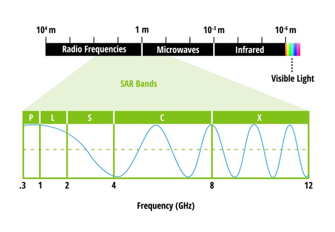
Radar bands have specific ranges of frequencies within the electromagnetic spectrum. These bands are designated by letters such as L-, S-, C-, and X-band. More on this later.
What Is Synthetic Aperture Radar?
Synthetic Aperture Radar (SAR) is an advanced form of radar for imaging the Earth’s surface. Unlike traditional radar systems, SAR uses the motion of the radar emitter and the target area. This simulates a much larger antenna or aperture electronically. The result is a higher-resolution image.
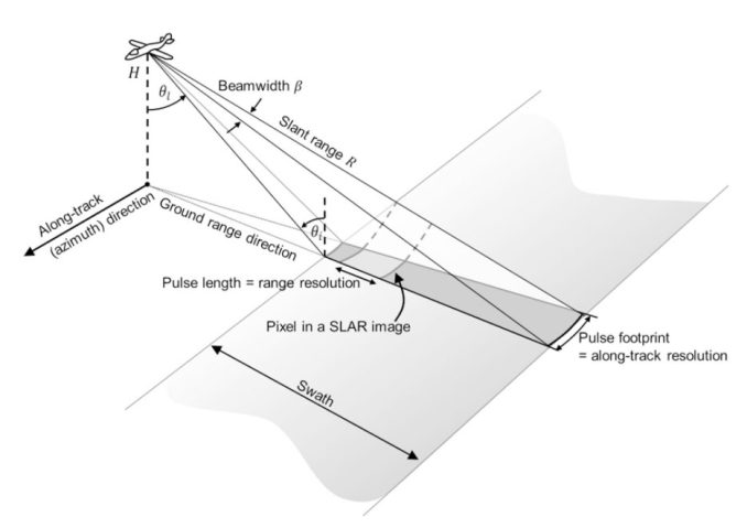
Whether it’s airborne or spaceborne, radar imaging transmits a microwave pulse sideways. Then, it measures the backscatter with land features. For example, it might detect forest branches, buildings, or even the ground.
We’ve already created this guide on SAR with examples. It’s a good place to start if you need to learn about the topic. What’s important to know is that SAR is an active sensor. Plus, it works in any weather condition and even at night.
Radar Bands in Synthetic Aperture Radar
The relationship between radar bands and SAR is key. This is because the choice of radar band affects the SAR system’s ability to penetrate surfaces. As such, specific radar bands are more common for different use cases.
The following table displays the most common radar bands in remote sensing and their applications.
| Band | Frequency | Wavelength | Applications and Use Cases |
|---|---|---|---|
| X | 8 – 12 GHz | 3.8 – 2.4 cm | Urban monitoring, ice and snow, weather monitoring, little penetration into vegetation cover |
| C | 4 – 8 GHz | 7.5 – 3.8 cm | Land use, agricultural monitoring, deforestation, ice, ocean, and maritime navigation |
| S | 2 – 4 GHz | 15 – 7.5 cm | Biomass, forestry management, soil moisture, geology, and hydrology |
| L | 1 – 2 GHz | 30 – 15 cm | Soil moisture, glaciers, geophysical monitoring; biomass and vegetation mapping; inSAR |
| P | 0.3 – 1 GHz | 100 – 30 cm | Deepest penetration capabilities, landslides, erosion, archaeology, and wetlands. |
SAR’s ability to use different radar bands allows it to be an incredibly valuable tool for Earth observation. For example, certain bands are adept at penetrating through dense forest canopies.
The choice of radar band is a trade-off based on the specific requirements of the SAR application. Microwave penetration depth in forests varies depending on the frequency. Here are some of the differences in radar bands in forested areas.
P-Band
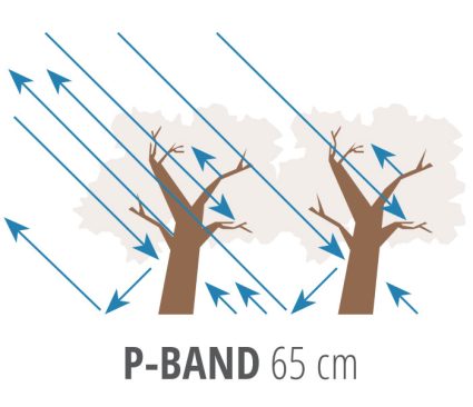
P-band waves can penetrate the tree canopy so it’s good for scattering from larger woody components of the forest. Because of its scattering within the canopy, it’s ideal for biomass measurements.
Most satellites in operation today are either C-band, L-band, or X-band. To fill in the void, ESA will launch the BIOMASS mission. This P-band sensor will help gather information on forest biomass around the world.
The aim is to generate maps of forest biomass and forest height at 200 meters resolution. Exploiting the unique sensitivity of P-band SAR, the BIOMASS mission will penetrate deep into the forest canopy.
L-Band
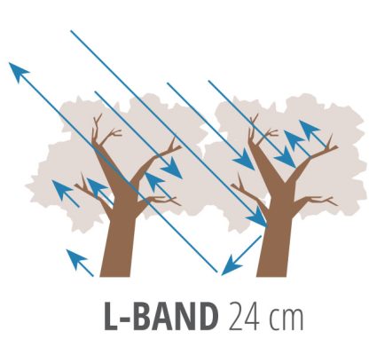
In the case of forests, L-band backscatter is more from the trunk and the branches of trees. Similar to the P-band, the L-band frequency can penetrate deep into forests for biomass measurements.
Some of the most common L-band sensors are Seasat, ALOS-1, and ALOS-2. Although these sensors contributed to global forest monitoring, they also assisted in disaster and natural resource detection.
For biomass estimation, L-band and P-band sensors are preferred over higher frequencies and smaller wavelengths. This is because of their unique ability to detect scattering from larger woody components within the forest canopy.
X-Band
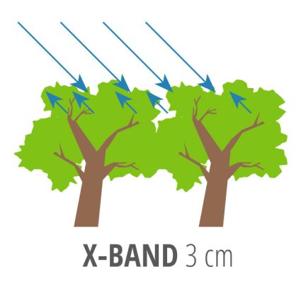
What is the X-band radar used for? In forestry, the X-band frequency can reflect off the surface of the canopy. So, this means its backscatter is more from a canopy’s leaves and needles.
TerraSAR-X is an example of a sensor that operates at the X-band. It provides measurements that are more sensitive to the biomass in low-density forests. For example, this includes sparse savannas, shrublands, grasslands, or crops
Other satellites that carry X-band instruments are COSMO-SkyMed and PAZ SAR. Both Italian and Spanish satellites can achieve a 1-meter resolution in Spotlight mode with a repeat cycle of 11 and 16 days.
C-Band
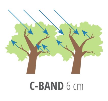
C-band is the workhorse of the radar bands. In fact, it’s the most common type of radar band. For example, Sentinel-1, ENVISAT, and the Radarsat Constellation Mission all operate at C-band frequencies in the range of 7.5 – 3.8 cm.
SAR C-band frequency penetration will be limited to the upper forest canopy in forestry applications. Backscatter is mostly by leaves and smaller branches. This is true unless the environment is in very sparse forest covers such as woodlands and savannas.
The range of applications is numerous. Oil spills, land cover, and ice and snow monitoring are some of the most common applications. Satellites like Sentinel-1 strike a balance between penetration capabilities, resolution, and sensitivity to atmospheric conditions.
SAR Satellites
This list of SAR satellites displays the sensor, lifetime, wavelength, and access constraints.
| Sensor | Lifetime | Wavelength | Access |
|---|---|---|---|
| Seasat | 1978 | L-band λ = 24.6cm | Free & open |
| ERS-1 | 1991-2001 | C-band λ = 5.6cm | Restrained |
| JERS-1 | 1995-1998 | L-band λ = 24.6cm | Restrained |
| ERS-2 | 1995-2011 | C-band λ = 5.6cm | Restrained |
| ENVISAT | 2002-2012 | C-band λ = 5.6cm | Restrained |
| ALOS-1 | 2006-2011 | L-band λ = 24.6cm | Free & open |
| Radarsat-1 | 1995-2013 | C-band λ = 5.6cm | 1995-2008: Restrained 2008-2013: Commercial |
| TerraSAR-XTanDEM-X | 2007-2010- | X-band λ = 3.5cm | Application-dependent; restrained scientific, commercial |
| Radarsat-2 | 2007- | C-band λ = 5.6cm | Commercial |
| COSMO-SkyMed | 2007- | X-band λ = 3.5cm | Commercial; limited proposal-based scientific |
| ALOS-2 PALSAR-2 | 2014- | L-band λ = 24.6cm | Commercial; limited proposal-based scientific |
| Sentinel-1 | 2014- | C-band λ = 5.6cm | Free & open |
| SAOCOM | 2018- | L-band λ = 24.6cm | TBD |
| PAZ SAR | 2018- | X-band λ = 3.5cm | Commercial |
| RADARSAT Constellation Mission | 2019 | C-bandλ = 5.6cm | TBD |
| NISAR | 2021 | L-band λ = 24.6cm | Free & open |
| BIOMASS | 2021 | P-band λ = 70.0cm | Free & open |
| TanDEM-L | 2023 | L-band λ = 24.6cm | Free & open |
Where are the S-, K-, Ku-, and Ka- Bands?
Each of these radar bands has its uses and applications in remote sensing. However, they are less common in synthetic aperture radar.
- K-band: This frequency spans from 18 to 26.5 GHz. This makes it susceptible to absorption by atmospheric water vapor.
- Ku-band: It’s common to use the Ku-band in altimetry. This includes oceanography applications like sea surface height and wave height.
- Ka-band: Airports use Ka-band radar sensors for integration into monitoring systems.
- S-band: Minimal but growing application in Earth observation.
While each of these radar bands offers a unique advantage, their adoption in SAR applications remains limited.


