Joshua Tree National Park Map
About the map
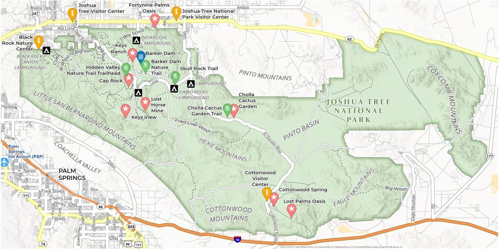
Our map of Joshua Tree National Park is your key to unlocking its diverse attractions. Discover places like Hidden Valley, perfect for a family hike. You’ll also find Keys View, which offers breathtaking panoramas of the Coachella Valley.
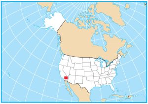
Joshua Tree National Park stands out because of its two distinct desert ecosystems. Situated in southeastern California (near Palm Springs), it’s where the Mojave Desert meets the Colorado Desert.
Our map of Joshua Tree National Park can help you navigate and plan your perfect trip. There’s Barker Dam, a peaceful water haven. Skull Rock is a simple boulder but has a skull-like resemblance. Find it all on our printable map so you can explore the park with ease.
You are free to use our Joshua Tree National Park map for educational and commercial uses. Attribution is required. How to attribute?
Top Things to Do
- Keys View: Panoramic vistas of Coachella Valley and San Andreas Fault.
- Hidden Valley Nature Trail: Scenic one-mile loop with diverse flora, boulders, and a legendary cattle rustlers’ hideout.
- Skull Rock Trail: Short trail leading to a unique, skull-shaped rock formation.
- Barker Dam: Historic dam offering desert and wildlife views.
- Cholla Cactus Garden: Dense concentration of Cholla cacti, especially beautiful at sunset.
- Keys Ranch: Guided tours of a well-preserved early 20th-century desert ranch.
- Cottonwood Spring: Oasis with a spring, hiking trails, and historical sites.
- Lost Palms Oasis: Remote oasis with a palm grove, accessed by a moderate hike.
- Fortynine Palms Oasis Trail: Challenging hike to a lush oasis with palm trees.
- Lost Horse Mine: Historic mine site accessible via a moderate hike.
Discovery and Visitor Centers
Joshua Tree National Park Visitor Center
Cottonwood Visitor Center
Joshua Tree Visitor Center
Black Rock Nature Center
Campgrounds
Black Rock Campground
Cottonwood Campground
Indian Cove Campground
Jumbo Rocks Campground
Ryan Campground
Landforms/Physical Regions
Coachella Valley
Little San Bernardino Mountains
Cottonwood Mountains
Hexie Mountains
Pinto Mountains
Eagle Mountains
Coxcomb Mountains
Ryan Mountain
Trails
Barker Dam Nature Trail
Hidden Valley Trail
Skull Rock Trail
Cholla Cactus Garden Trail
Big Wash Trail
Highways and Roads
California State Route 62
El Dorado Mine Rd
Cottonwood Spring Rd
Boy Scout Rd
Quail Springs Rd
Interstate 10 (I-10)
References
- Joshua Tree National Park (National Park Service)
- USGS Joshua Tree National Park Map
- Topographic Maps of Joshua Tree NP (USGS)