Michigan County Map


You are free to use our county map of Michigan for educational and commercial uses. Attribution is required. How to attribute?
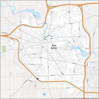
About the map
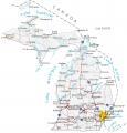
This Michigan county map displays its 83 counties, which ranks 15th for the number of counties. The geography of Michigan is very unique compared to other states. This is because Lake Michigan actually splits it into two separate pieces.
By far, the most populated county in Michigan is Wayne County with close to 1.75 million people. Next comes Oakland, Macomb, and Kent County. The least populated county in Michigan is Keweenaw County with just over 2000 residents.
For area, Marquette County in northwest Michigan is the largest. But the smallest county is Benzie County which occupies an area of about 350 square miles. Also notable, both Keweenaw and Charlevoix County contain island(s) that are not part of the mainland in Michigan.
Michigan county list
| FIPS Code | Name | Land (sq mi) | Water (sq mi) | Population (2024) |
|---|---|---|---|---|
| 26-001 | Alcona County | 674.7 | 1116.0 | 10,624 |
| 26-003 | Alger County | 915.0 | 4132.6 | 8,695 |
| 26-005 | Allegan County | 825.2 | 1008.0 | 122,429 |
| 26-007 | Alpena County | 571.9 | 1123.1 | 28,903 |
| 26-009 | Antrim County | 475.7 | 126.1 | 24,536 |
| 26-011 | Arenac County | 363.2 | 317.5 | 15,087 |
| 26-013 | Baraga County | 898.4 | 170.5 | 8,169 |
| 26-015 | Barry County | 553.1 | 23.9 | 64,025 |
| 26-017 | Bay County | 442.2 | 188.5 | 102,651 |
| 26-019 | Benzie County | 319.7 | 539.9 | 18,520 |
| 26-021 | Berrien County | 567.8 | 1013.7 | 152,703 |
| 26-023 | Branch County | 506.4 | 13.3 | 46,187 |
| 26-025 | Calhoun County | 706.3 | 12.1 | 133,785 |
| 26-027 | Cass County | 490.1 | 18.2 | 51,550 |
| 26-029 | Charlevoix County | 416.3 | 974.1 | 26,105 |
| 26-031 | Cheboygan County | 715.3 | 170.1 | 25,964 |
| 26-033 | Chippewa County | 1558.5 | 1140.0 | 36,253 |
| 26-035 | Clare County | 564.4 | 11.0 | 31,405 |
| 26-037 | Clinton County | 566.4 | 8.1 | 80,050 |
| 26-039 | Crawford County | 556.4 | 6.9 | 13,599 |
| 26-041 | Delta County | 1171.1 | 820.2 | 36,687 |
| 26-043 | Dickinson County | 760.9 | 15.6 | 25,995 |
| 26-045 | Eaton County | 575.2 | 4.2 | 109,494 |
| 26-047 | Emmet County | 467.5 | 414.5 | 33,949 |
| 26-049 | Genesee County | 637.0 | 12.6 | 402,279 |
| 26-051 | Gladwin County | 501.8 | 14.2 | 25,995 |
| 26-053 | Gogebic County | 1102.1 | 374.6 | 14,217 |
| 26-055 | Grand Traverse County | 464.3 | 137.0 | 96,625 |
| 26-057 | Gratiot County | 568.4 | 3.2 | 41,372 |
| 26-059 | Hillsdale County | 598.1 | 8.9 | 45,590 |
| 26-061 | Houghton County | 1009.1 | 492.4 | 38,041 |
| 26-063 | Huron County | 836.0 | 1300.8 | 30,780 |
| 26-065 | Ingham County | 556.1 | 4.6 | 290,427 |
| 26-067 | Ionia County | 571.3 | 8.7 | 66,250 |
| 26-069 | Iosco County | 549.1 | 1341.0 | 25,361 |
| 26-071 | Iron County | 1166.0 | 45.1 | 11,709 |
| 26-073 | Isabella County | 572.7 | 5.0 | 65,072 |
| 26-075 | Jackson County | 701.9 | 21.6 | 160,233 |
| 26-077 | Kalamazoo County | 562.1 | 18.2 | 264,780 |
| 26-079 | Kalkaska County | 559.7 | 10.8 | 18,618 |
| 26-081 | Kent County | 848.0 | 23.9 | 673,002 |
| 26-083 | Keweenaw County | 540.1 | 5426.1 | 2,161 |
| 26-085 | Lake County | 567.6 | 6.8 | 13,005 |
| 26-087 | Lapeer County | 644.6 | 18.3 | 89,168 |
| 26-089 | Leelanau County | 347.2 | 2185.0 | 22,871 |
| 26-091 | Lenawee County | 749.6 | 11.8 | 97,746 |
| 26-093 | Livingston County | 565.2 | 20.2 | 196,976 |
| 26-095 | Luce County | 899.1 | 1013.4 | 6,328 |
| 26-097 | Mackinac County | 1021.9 | 1078.7 | 11,144 |
| 26-099 | Macomb County | 479.2 | 91.7 | 886,175 |
| 26-101 | Manistee County | 542.3 | 738.4 | 25,519 |
| 26-103 | Marquette County | 1809.0 | 1616.0 | 67,979 |
| 26-105 | Mason County | 495.0 | 747.3 | 29,093 |
| 26-107 | Mecosta County | 555.1 | 16.1 | 41,947 |
| 26-109 | Menominee County | 1044.0 | 294.1 | 23,050 |
| 26-111 | Midland County | 516.3 | 11.8 | 84,022 |
| 26-113 | Missaukee County | 564.8 | 9.1 | 15,239 |
| 26-115 | Monroe County | 549.3 | 130.6 | 156,045 |
| 26-117 | Montcalm County | 705.3 | 15.4 | 69,314 |
| 26-119 | Montmorency County | 546.7 | 16.0 | 9,828 |
| 26-121 | Muskegon County | 503.9 | 956.1 | 177,428 |
| 26-123 | Newaygo County | 838.9 | 22.8 | 51,504 |
| 26-125 | Oakland County | 867.4 | 39.8 | 1,296,888 |
| 26-127 | Oceana County | 538.1 | 767.9 | 27,014 |
| 26-129 | Ogemaw County | 563.5 | 11.4 | 20,985 |
| 26-131 | Ontonagon County | 1311.0 | 2429.5 | 5,824 |
| 26-133 | Osceola County | 566.3 | 6.7 | 23,484 |
| 26-135 | Oscoda County | 565.7 | 5.8 | 8,596 |
| 26-137 | Otsego County | 515.0 | 11.2 | 26,083 |
| 26-139 | Ottawa County | 563.5 | 1067.9 | 306,235 |
| 26-141 | Presque Isle County | 658.7 | 1914.0 | 13,230 |
| 26-143 | Roscommon County | 519.9 | 60.1 | 23,932 |
| 26-145 | Saginaw County | 800.5 | 15.5 | 187,714 |
| 26-147 | St. Clair County | 721.3 | 115.2 | 160,308 |
| 26-149 | St. Joseph County | 500.6 | 20.4 | 61,171 |
| 26-151 | Sanilac County | 962.6 | 627.4 | 40,293 |
| 26-153 | Schoolcraft County | 1171.9 | 712.1 | 8,178 |
| 26-155 | Shiawassee County | 531.0 | 10.0 | 67,982 |
| 26-157 | Tuscola County | 804.5 | 109.4 | 52,757 |
| 26-159 | Van Buren County | 607.8 | 482.1 | 76,129 |
| 26-161 | Washtenaw County | 706.0 | 16.4 | 373,875 |
| 26-163 | Wayne County | 612.0 | 60.8 | 1,771,063 |
| 26-165 | Wexford County | 564.9 | 10.5 | 34,460 |
the Michigan county list is labeled Massachusetts county list
Thanks, fixed it