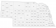
Nebraska County Map
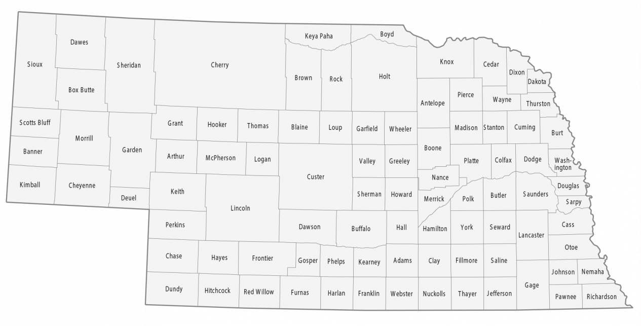
About the map
This Nebraska county map displays its 93 counties. 93 counties represent the 11th most counties in the entire United States, so Nebraska has quite a few. But one unique thing about Nebraska is that it has some of the emptiest counties in the US. It has 9 counties out of the 20 least populated counties.
Logan, Banner, Thomas, Hooker, Loup, Grant, McPherson, Blaine, and Arthur County have less than 750 people. But in the whole United States, the least populated county is Kalawao County in Hawaii. The county with the highest population in Nebraska is Douglas County because it’s home to Omaha, Nebraska. In fact, one-quarter of Nebraska’s population resides in Douglas County.
In terms of size, Cherry County is the largest occupying over 6000 square miles. It more than doubles the second-largest county in Nebraska, Custer County. Conversely, the smallest county in Nebraska is Sarpy County with an area of less than 250 square miles.
You are free to use our county map of Nebraska for educational and commercial uses. Attribution is required. How to attribute?
Nebraska county list
| FIPS Code | Name | Land (sq mi) | Water (sq mi) | Population (2024) |
|---|---|---|---|---|
| 31-001 | Adams County | 563.3 | 1.0 | 31,196 |
| 31-003 | Antelope County | 857.2 | 1.4 | 6,358 |
| 31-005 | Arthur County | 715.4 | 3.0 | 423 |
| 31-007 | Banner County | 746.2 | 0.2 | 665 |
| 31-009 | Blaine County | 710.7 | 3.6 | 454 |
| 31-011 | Boone County | 686.6 | 0.7 | 5,354 |
| 31-013 | Box Butte County | 1075.3 | 2.5 | 10,703 |
| 31-015 | Boyd County | 539.9 | 4.6 | 1,700 |
| 31-017 | Brown County | 1221.3 | 3.8 | 2,877 |
| 31-019 | Buffalo County | 968.2 | 7.2 | 51,156 |
| 31-021 | Burt County | 491.6 | 5.5 | 6,727 |
| 31-023 | Butler County | 584.9 | 5.9 | 8,439 |
| 31-025 | Cass County | 557.4 | 8.5 | 27,492 |
| 31-027 | Cedar County | 740.2 | 5.6 | 8,262 |
| 31-029 | Chase County | 894.4 | 3.1 | 3,764 |
| 31-031 | Cherry County | 5960.2 | 49.2 | 5,558 |
| 31-033 | Cheyenne County | 1196.3 | 0.1 | 9,602 |
| 31-035 | Clay County | 572.3 | 1.2 | 6,103 |
| 31-037 | Colfax County | 411.6 | 4.9 | 10,826 |
| 31-039 | Cuming County | 570.5 | 4.1 | 8,952 |
| 31-041 | Custer County | 2575.6 | 0.4 | 10,487 |
| 31-043 | Dakota County | 264.3 | 3.2 | 21,335 |
| 31-045 | Dawes County | 1396.5 | 4.6 | 8,003 |
| 31-047 | Dawson County | 1013.1 | 6.3 | 24,554 |
| 31-049 | Deuel County | 439.8 | 0.9 | 1,892 |
| 31-051 | Dixon County | 476.1 | 6.6 | 5,526 |
| 31-053 | Dodge County | 529.1 | 13.9 | 37,884 |
| 31-055 | Douglas County | 326.4 | 12.9 | 601,158 |
| 31-057 | Dundy County | 919.7 | 1.2 | 1,581 |
| 31-059 | Fillmore County | 575.4 | 1.2 | 5,512 |
| 31-061 | Franklin County | 575.8 | 0.2 | 2,817 |
| 31-063 | Frontier County | 974.6 | 5.4 | 2,536 |
| 31-065 | Furnas County | 719.1 | 1.5 | 4,468 |
| 31-067 | Gage County | 851.5 | 8.5 | 21,687 |
| 31-069 | Garden County | 1705.4 | 25.4 | 1,804 |
| 31-071 | Garfield County | 569.3 | 2.1 | 1,707 |
| 31-073 | Gosper County | 458.2 | 4.6 | 1,808 |
| 31-075 | Grant County | 776.9 | 6.4 | 573 |
| 31-077 | Greeley County | 569.8 | 0.8 | 2,197 |
| 31-079 | Hall County | 546.4 | 5.8 | 62,869 |
| 31-081 | Hamilton County | 541.9 | 2.8 | 9,564 |
| 31-083 | Harlan County | 553.5 | 20.6 | 3,018 |
| 31-085 | Hayes County | 713.1 | 0.2 | 846 |
| 31-087 | Hitchcock County | 709.9 | 8.5 | 2,460 |
| 31-089 | Holt County | 2412.4 | 5.1 | 10,120 |
| 31-091 | Hooker County | 721.2 | 0.3 | 698 |
| 31-093 | Howard County | 569.3 | 6.3 | 6,572 |
| 31-095 | Jefferson County | 570.2 | 5.5 | 7,136 |
| 31-097 | Johnson County | 376.1 | 0.7 | 5,219 |
| 31-099 | Kearney County | 516.2 | 0.1 | 6,749 |
| 31-101 | Keith County | 1061.6 | 48.1 | 8,148 |
| 31-103 | Keya Paha County | 773.1 | 0.8 | 819 |
| 31-105 | Kimball County | 951.8 | 0.6 | 3,305 |
| 31-107 | Knox County | 1108.4 | 31.3 | 8,306 |
| 31-109 | Lancaster County | 837.6 | 8.8 | 332,857 |
| 31-111 | Lincoln County | 2564.1 | 11.0 | 33,319 |
| 31-113 | Logan County | 570.7 | 0.5 | 694 |
| 31-115 | Loup County | 563.5 | 7.6 | 582 |
| 31-117 | McPherson County | 859.0 | 1.0 | 376 |
| 31-119 | Madison County | 572.6 | 2.8 | 35,579 |
| 31-121 | Merrick County | 485.8 | 10.9 | 7,837 |
| 31-123 | Morrill County | 1423.8 | 6.0 | 4,485 |
| 31-125 | Nance County | 441.6 | 6.6 | 3,262 |
| 31-127 | Nemaha County | 407.4 | 2.2 | 7,046 |
| 31-129 | Nuckolls County | 575.2 | 0.7 | 4,094 |
| 31-131 | Otoe County | 615.7 | 3.4 | 16,591 |
| 31-133 | Pawnee County | 431.1 | 1.9 | 2,521 |
| 31-135 | Perkins County | 883.3 | 1.1 | 2,779 |
| 31-137 | Phelps County | 539.8 | 0.6 | 9,042 |
| 31-139 | Pierce County | 573.2 | 1.3 | 7,334 |
| 31-141 | Platte County | 674.1 | 10.5 | 35,499 |
| 31-143 | Polk County | 438.3 | 2.3 | 5,269 |
| 31-145 | Red Willow County | 717.0 | 1.0 | 10,409 |
| 31-147 | Richardson County | 551.8 | 2.7 | 7,666 |
| 31-149 | Rock County | 1008.3 | 3.4 | 1,241 |
| 31-151 | Saline County | 574.1 | 2.2 | 14,740 |
| 31-153 | Sarpy County | 238.2 | 9.4 | 204,828 |
| 31-155 | Saunders County | 750.3 | 9.5 | 23,406 |
| 31-157 | Scotts Bluff County | 739.4 | 5.9 | 35,734 |
| 31-159 | Seward County | 571.4 | 4.5 | 17,769 |
| 31-161 | Sheridan County | 2440.9 | 28.8 | 4,927 |
| 31-163 | Sherman County | 565.8 | 5.8 | 2,949 |
| 31-165 | Sioux County | 2066.7 | 0.6 | 1,099 |
| 31-167 | Stanton County | 427.6 | 3.4 | 5,756 |
| 31-169 | Thayer County | 573.8 | 1.2 | 4,870 |
| 31-171 | Thomas County | 712.9 | 0.8 | 634 |
| 31-173 | Thurston County | 393.6 | 2.5 | 6,637 |
| 31-175 | Valley County | 568.1 | 2.3 | 4,032 |
| 31-177 | Washington County | 390.0 | 3.2 | 21,254 |
| 31-179 | Wayne County | 442.9 | 0.4 | 9,870 |
| 31-181 | Webster County | 574.9 | 0.1 | 3,326 |
| 31-183 | Wheeler County | 575.2 | 0.4 | 808 |
| 31-185 | York County | 572.5 | 3.3 | 14,375 |
Wood River has grown so much. A lot of new homes have been built and have made so much improvement. There are 100% senior living places. That is where I live in two bedrooms and a kitchen area… just like you would have a laundry room, bathroom, shower tub, a garage for your car patio on back side table chairs, and a grill to cook on beautifully compared to when I moved to Colo. My husband & I loved it out there but he came down with ALS AFTER that I decided to sell our house and come back home good old Wood River Eagles going fine sure missed everybody!!!!!!