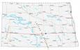
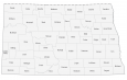
North Dakota County Map

About the map
This North Dakota county map displays its 53 counties. Cass, Burleigh, and Grand Forks County have the highest population of all counties in North Dakota.
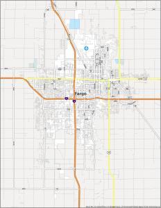
Cass County has the highest population with an estimated population of 181,923 with the major city of Fargo, North Dakota. But the least populated is Slope County with just 750 residents. In fact, it has such few people that it’s ranked as the 21st least populated county in the United States.
In terms of size, McKenzie County is the largest with an area of 2858.2 square miles. This farming and oil county borders the east boundary of Montana. Conversely, the smallest county in North Dakota is Eddy County with an area of 643.8 square miles in size.
You are free to use our county map of North Dakota for educational and commercial uses. Attribution is required. How to attribute?
North Dakota County List
| FIPS Code | Name | Land (sq mi) | Water (sq mi) | Population (2024) |
|---|---|---|---|---|
| 38-001 | Adams County | 987.6 | 1.1 | 2,141 |
| 38-003 | Barnes County | 1491.5 | 21.8 | 10,798 |
| 38-005 | Benson County | 1388.6 | 50.9 | 5,756 |
| 38-007 | Billings County | 1148.8 | 4.6 | 1,063 |
| 38-009 | Bottineau County | 1668.4 | 28.9 | 6,391 |
| 38-011 | Bowman County | 1161.9 | 5.2 | 2,886 |
| 38-013 | Burke County | 1103.6 | 25.4 | 2,154 |
| 38-015 | Burleigh County | 1632.5 | 35.8 | 103,107 |
| 38-017 | Cass County | 1765.0 | 2.9 | 200,945 |
| 38-019 | Cavalier County | 1489.0 | 21.0 | 3,567 |
| 38-021 | Dickey County | 1131.5 | 10.7 | 4,930 |
| 38-023 | Divide County | 1260.7 | 33.4 | 2,124 |
| 38-025 | Dunn County | 2008.5 | 73.6 | 4,031 |
| 38-027 | Eddy County | 630.2 | 13.9 | 2,309 |
| 38-029 | Emmons County | 1509.7 | 45.3 | 3,209 |
| 38-031 | Foster County | 635.4 | 11.4 | 3,323 |
| 38-033 | Golden Valley County | 1001.5 | 1.6 | 1,795 |
| 38-035 | Grand Forks County | 1436.1 | 3.4 | 73,771 |
| 38-037 | Grant County | 1659.1 | 6.8 | 2,247 |
| 38-039 | Griggs County | 708.8 | 7.6 | 2,227 |
| 38-041 | Hettinger County | 1132.2 | 1.5 | 2,419 |
| 38-043 | Kidder County | 1351.2 | 81.7 | 2,371 |
| 38-045 | LaMoure County | 1145.9 | 4.9 | 4,051 |
| 38-047 | Logan County | 992.8 | 18.4 | 1,880 |
| 38-049 | McHenry County | 1874.0 | 37.6 | 5,135 |
| 38-051 | McIntosh County | 974.7 | 20.0 | 2,461 |
| 38-053 | McKenzie County | 2760.5 | 100.4 | 14,782 |
| 38-055 | McLean County | 2110.3 | 217.7 | 9,845 |
| 38-057 | Mercer County | 1042.7 | 69.8 | 8,348 |
| 38-059 | Morton County | 1926.2 | 19.3 | 34,194 |
| 38-061 | Mountrail County | 1825.3 | 116.3 | 9,474 |
| 38-063 | Nelson County | 981.8 | 27.0 | 3,007 |
| 38-065 | Oliver County | 722.5 | 8.7 | 1,882 |
| 38-067 | Pembina County | 1118.7 | 2.7 | 6,588 |
| 38-069 | Pierce County | 1018.5 | 63.9 | 3,853 |
| 38-071 | Ramsey County | 1186.9 | 114.0 | 11,510 |
| 38-073 | Ransom County | 862.4 | 1.4 | 5,590 |
| 38-075 | Renville County | 877.0 | 15.7 | 2,376 |
| 38-077 | Richland County | 1435.8 | 9.7 | 16,658 |
| 38-079 | Rolette County | 903.1 | 36.3 | 11,692 |
| 38-081 | Sargent County | 858.5 | 8.4 | 3,710 |
| 38-083 | Sheridan County | 972.4 | 33.3 | 1,268 |
| 38-085 | Sioux County | 1094.1 | 34.2 | 3,713 |
| 38-087 | Slope County | 1214.9 | 4.2 | 660 |
| 38-089 | Stark County | 1334.8 | 5.4 | 33,767 |
| 38-091 | Steele County | 712.2 | 3.3 | 1,767 |
| 38-093 | Stutsman County | 2221.7 | 76.2 | 21,546 |
| 38-095 | Towner County | 1024.6 | 16.9 | 2,051 |
| 38-097 | Traill County | 861.9 | 0.6 | 7,989 |
| 38-099 | Walsh County | 1281.7 | 12.4 | 10,214 |
| 38-101 | Ward County | 2013.0 | 42.9 | 68,427 |
| 38-103 | Wells County | 1270.6 | 19.7 | 3,803 |
| 38-105 | Williams County | 2077.9 | 70.2 | 40,763 |