Ocean Currents Map: Visualize Our Oceans Movement

Ocean Currents Map
If you look at a world map, about 71% of the world is water. And a significant amount of this water is from water held in oceans.
Ocean currents are like giant conveyor belts because they move large amounts of water every day.
Because ocean currents transfer heat from one region to another, it has a significant impact on Earth’s weather and climate.
Let’s take a look at ocean current maps to see ocean movement in near real-time.
1. Earth NullSchool Ocean Currents Map
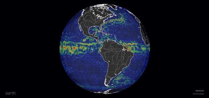
Earth Null School is best known for its cool wind and temperature visualizations of our planet. But a little lesser-known web map from Earth Nullschool is their ocean currents map.
As you can see, hot water flows to the poles from the equator. For example, the Gulf Stream pushes warm air to Europe.
As the hot water flows through the Atlantic Ocean, it makes the climate more moderate. This is why the temperature is moderate on the west coast of Europe.
2. NASA’s Ocean Eddies (Circular Currents)
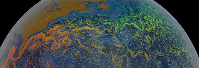
As temperature always hits an equilibrium, hot water currents from the equator collide with cold water ocean currents from the poles.
Because the world is spinning on its axis, water flows in a circular pattern. For example, ocean currents in the northern hemisphere spin mostly clockwise. But in the southern hemisphere, ocean currents rotate mostly counter-clockwise.
Similar to the dial on a clock, this creates a circular pattern of colliding warm and cool water. NASA’s Scientific Visual Studio ocean currents map beautifully displays this phenomenon of ocean eddies with colorful vector gradients.
3. NOAA NowCOAST
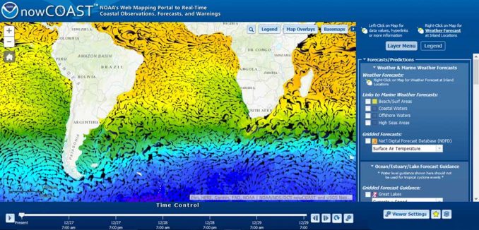
NowCOAST is NOAA’s web mapping portal with real-time coastal observations, forecasts, and warnings.
If you are a mariner, you’ll find everything you need here. For example, it has real-time coastal meteorological, oceanographic, and hydrologic observations.
Overall, it’s a little difficult to navigate on a mobile phone, Android at least. For all other devices, it’s a “one-stop shop” for all your ocean mapping needs.
How do these maps track ocean currents?
There are several ways to monitor ocean currents for these ocean current maps.
- Data marker buoys in the ocean send radio signals for us to follow where they start and end.
- Satellites like Poseidon and Jason-3 observe ocean currents from space by measuring sea surface height.
- And underwater robots like Argo track deep ocean currents.
As we begin to better understand our oceans, these maps keep track of their dynamic nature.


