3 Wildfire Maps for Tracking Real-Time Forest Fires

Active Fire Maps: Real-Time Forest Fires
As wildfires ignite forests into ashes, orbiting satellites track where they burn and how severe they are. Specifically, satellites capture wildfires as they happen and stream this information in active fire maps.
So in near real-time, decision-makers have critical information for saving money and preserving life.
But which active fire maps can you track wildfires in real time? And which wildfires web services, shapefiles, and KML/KMZ are available?
Also, what satellites are tracking forest fires in near real-time? And how can you see this satellite imagery for yourself?
READ MORE: 15 Free Satellite Imagery Data Sources
1. Google Earth Pro
Google Earth Pro is a handy tool that helps you sight-see the planet. And the best part is that it’s never a cloudy day. Even though the imagery is usually less than a year old, chances are that you won’t see a forest fire in the application. But really, all it takes is some legwork to get started.
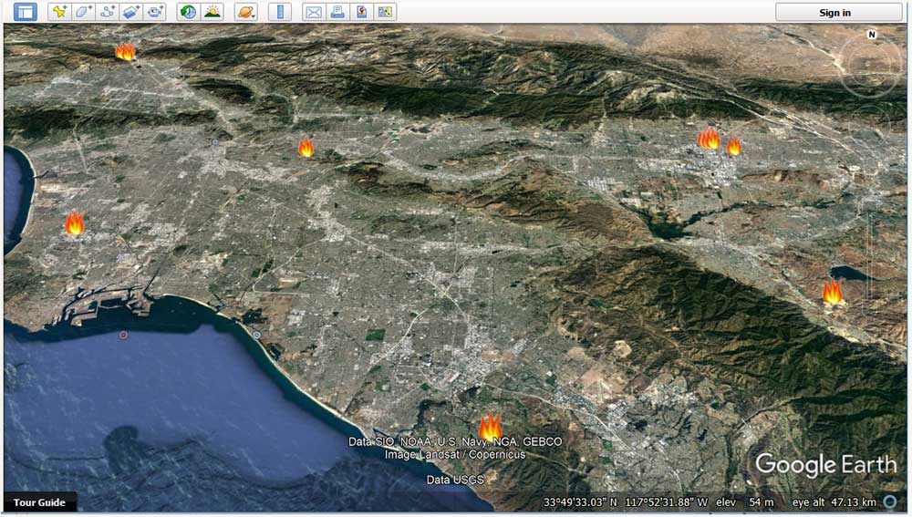
First, download the latest active fire data from NASA. Next, drag and drop the KMZ into Google Earth Pro. As you can see above, the latest forest fires will pop up with fire symbols. If you want to see a snapshot of the fire, your best chance is to use a Landsat scene from the USGS Earth Explorer.
Fortunately, we have a tutorial on how to download Landsat data. Select your area and time frame. Then, choose Landsat-8. The image type you want is Landsat Look with Geographic Reference (Data Sets > Landsat > Landsat Collection 2 Level 1 > Landsat 8-9 OLI/TIRS). Download it. Finally, drag and drop the Landsat image into Google Earth Pro without any extra processing.
If you downloaded the correct date and time, you should be able to see the forest fire. As you can see below, here is a satellite view of the December 2017 wildfires in California. But you can apply this same idea anywhere in the world!
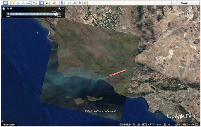
Not only is Google Earth Pro good for active forest fires but also for measuring the footprint of the burned area. It’s easy to get confused with clouds for Landsat images, so you can verify the fire with thermal infrared (TIR) and the KMZ.
2. NASA’s Worldview and FIRMS
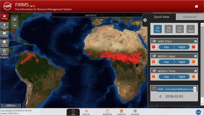
Not only is NASA Worldview an active fires map, but it’s also a live imagery map. This means that you can see forest fires and (coarse) imagery as they are collected in near real-time. If you want to view fires in Worldview, click “Add Layers” and it has a whole category for wildfire data.
If you need better imagery for a basemap, NASA’s Fire Information for Resource Management System (FIRMS) is a feature-rich interactive fire map. In this web map, you can visualize daily global fire locations within 3 hours of satellite overpass from both MODIS (Moderate Resolution Imaging Spectroradiometer) and VIIRS satellites. More on these sensors later.
3. Copernicus Emergency Management Services
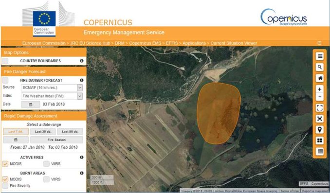
Lastly, the Copernicus Emergency Management Services targets users in Europe. Similar to the other active fire maps, the European Forest Fire Information System (EFFIS) uses MODIS and VIIRS to track thermal anomalies.
As part of their current situation viewer, it assesses the burnt area of the forest fire with a polygon extent. Also, it provides an analysis of seasonal trends and the number of fires by European Union countries. For fire prevention managers, this platform forecasts fire danger levels based on meteorological predictions.
Monitoring Real-Time Forest Fires with MODIS and VIIRS
History shows that when wildfires get out of hand, they can be costly and deadly to people nearby. Fortunately, satellites can track forest fires and deliver warnings to emergency crews.
The fire detection algorithm compares the temperature of a potential fire with the temperature of the land around it. If the difference is over a given threshold, it confirms the “hot spot” as an active wildfire. But if the fire is too small to detect due to the spatial resolution of the sensor, the satellite won’t be able to detect it.
- MODIS: On board Terra and Aqua satellites, MODIS has a pixel resolution of 1 km. As explained above, it detects active fires by comparing temperature to neighboring pixels but it depends on the severity and extent of the fire.
- VIIRS: Likewise, VIIRS on board the NASA/NOAA Suomi NPP detects active forest fires based on thermal anomalies. Because of its finer spatial resolution (375 meters), it can detect smaller fires on the ground with a bit more accuracy.
Detecting forest fires is just one of the hundreds of remote sensing and satellite applications in use today.


Can I use this to see crop burning around the world? If not, where?
Hi Ken. One way to do this would be to check out EOSDIS Worldview. Then, you can turn on both the “active fires” and “land cover” – filtering out “croplands” which is a shade of yellow.
The active fires don’t single out only “crop burning” from what I can tell. Instead, you would need an overlay of two layers in the application to see where the active fires are occurring and where the land cover type is “agriculture”.
Can I get historical fire perimeters for google earth? I managed to erase mine, the Telegraph Fire, and the Detwiler Fire. I need them, because I live near the Briceburg Fire. Thank you. Ruth