Oklahoma County Map

About the map
This Oklahoma county map displays its 77 counties. This tally of 77 ranks the 17th highest for the number of counties in the United States.
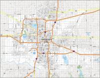
Oklahoma County is the most populated county in the state of Oklahoma with close to 800,000 people. This is primarily because the state capital, Oklahoma City, is located in this county. The least populated county in Oklahoma is Cimarron County with just over 2000 residents.
For size, Osage County is the largest, occupying an area of over 2300 square miles. Conversely, the smallest county in Oklahoma is Marshall County in southeast Oklahoma with an area of 422 square miles.
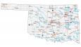
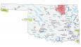
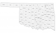
You are free to use our county map of Oklahoma for educational and commercial uses. Attribution is required. How to attribute?
Oklahoma County List
| FIPS Code | Name | Land (sq mi) | Water (sq mi) | Population (2024) |
|---|---|---|---|---|
| 40-001 | Adair County | 573.7 | 3.4 | 19,821 |
| 40-003 | Alfalfa County | 866.5 | 14.9 | 5,712 |
| 40-005 | Atoka County | 975.5 | 14.4 | 14,600 |
| 40-007 | Beaver County | 1814.7 | 2.8 | 5,025 |
| 40-009 | Beckham County | 901.8 | 2.1 | 22,248 |
| 40-011 | Blaine County | 928.4 | 10.4 | 8,573 |
| 40-013 | Bryan County | 904.5 | 39.4 | 50,305 |
| 40-015 | Caddo County | 1277.8 | 12.3 | 26,337 |
| 40-017 | Canadian County | 896.6 | 9.0 | 181,760 |
| 40-019 | Carter County | 822.2 | 11.6 | 49,135 |
| 40-021 | Cherokee County | 749.3 | 27.0 | 48,729 |
| 40-023 | Choctaw County | 770.4 | 29.2 | 14,174 |
| 40-025 | Cimarron County | 1834.8 | 6.1 | 2,133 |
| 40-027 | Cleveland County | 538.9 | 19.2 | 303,952 |
| 40-029 | Coal County | 516.7 | 4.7 | 5,414 |
| 40-031 | Comanche County | 1069.3 | 14.4 | 121,396 |
| 40-033 | Cotton County | 632.7 | 9.3 | 5,503 |
| 40-035 | Craig County | 761.4 | 1.4 | 14,506 |
| 40-037 | Creek County | 950.2 | 19.7 | 73,971 |
| 40-039 | Custer County | 988.8 | 13.3 | 28,266 |
| 40-041 | Delaware County | 738.1 | 54.2 | 41,771 |
| 40-043 | Dewey County | 999.5 | 8.8 | 4,268 |
| 40-045 | Ellis County | 1231.5 | 0.4 | 3,601 |
| 40-047 | Garfield County | 1058.5 | 1.6 | 62,007 |
| 40-049 | Garvin County | 802.1 | 11.6 | 26,149 |
| 40-051 | Grady County | 1100.5 | 4.4 | 58,353 |
| 40-053 | Grant County | 1000.9 | 2.7 | 4,123 |
| 40-055 | Greer County | 639.3 | 4.3 | 5,433 |
| 40-057 | Harmon County | 537.2 | 1.5 | 2,315 |
| 40-059 | Harper County | 1039.0 | 2.0 | 3,209 |
| 40-061 | Haskell County | 576.5 | 48.7 | 11,811 |
| 40-063 | Hughes County | 804.6 | 10.2 | 13,371 |
| 40-065 | Jackson County | 802.6 | 1.6 | 24,541 |
| 40-067 | Jefferson County | 758.8 | 15.2 | 5,374 |
| 40-069 | Johnston County | 642.9 | 15.3 | 10,293 |
| 40-071 | Kay County | 919.6 | 25.3 | 43,437 |
| 40-073 | Kingfisher County | 898.1 | 8.0 | 15,820 |
| 40-075 | Kiowa County | 1015.1 | 15.6 | 8,257 |
| 40-077 | Latimer County | 722.0 | 7.1 | 9,509 |
| 40-079 | Le Flore County | 1589.3 | 19.3 | 49,854 |
| 40-081 | Lincoln County | 952.3 | 13.4 | 34,972 |
| 40-083 | Logan County | 743.8 | 5.0 | 53,860 |
| 40-085 | Love County | 514.0 | 18.3 | 10,423 |
| 40-087 | McClain County | 570.7 | 9.5 | 48,434 |
| 40-089 | McCurtain County | 1850.6 | 51.7 | 30,805 |
| 40-091 | McIntosh County | 618.5 | 93.8 | 19,710 |
| 40-093 | Major County | 955.0 | 3.0 | 7,569 |
| 40-095 | Marshall County | 371.6 | 55.4 | 16,147 |
| 40-097 | Mayes County | 655.4 | 28.1 | 40,144 |
| 40-099 | Murray County | 416.3 | 8.8 | 13,754 |
| 40-101 | Muskogee County | 810.4 | 29.4 | 66,752 |
| 40-103 | Noble County | 731.9 | 10.6 | 10,896 |
| 40-105 | Nowata County | 565.8 | 15.0 | 9,561 |
| 40-107 | Okfuskee County | 618.6 | 10.3 | 11,364 |
| 40-109 | Oklahoma County | 708.8 | 9.5 | 816,490 |
| 40-111 | Okmulgee County | 697.3 | 5.0 | 37,084 |
| 40-113 | Osage County | 2246.5 | 57.4 | 46,495 |
| 40-115 | Ottawa County | 470.8 | 13.8 | 30,404 |
| 40-117 | Pawnee County | 568.2 | 26.6 | 16,111 |
| 40-119 | Payne County | 684.7 | 12.3 | 84,199 |
| 40-121 | Pittsburg County | 1305.5 | 72.4 | 43,395 |
| 40-123 | Pontotoc County | 720.4 | 4.8 | 38,310 |
| 40-125 | Pottawatomie County | 787.7 | 5.7 | 74,446 |
| 40-127 | Pushmataha County | 1395.8 | 27.0 | 10,800 |
| 40-129 | Roger Mills County | 1141.1 | 5.3 | 3,304 |
| 40-131 | Rogers County | 675.6 | 35.9 | 101,371 |
| 40-133 | Seminole County | 632.8 | 7.6 | 23,351 |
| 40-135 | Sequoyah County | 673.3 | 40.9 | 40,555 |
| 40-137 | Stephens County | 870.2 | 21.1 | 44,075 |
| 40-139 | Texas County | 2041.3 | 7.4 | 20,577 |
| 40-141 | Tillman County | 871.1 | 8.1 | 6,736 |
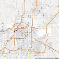
| 40-143 | Tulsa County | 570.3 | 16.7 | 693,514 |
| 40-145 | Wagoner County | 561.6 | 29.1 | 91,257 |
| 40-147 | Washington County | 415.5 | 8.8 | 54,060 |
| 40-149 | Washita County | 1003.2 | 5.6 | 10,839 |
| 40-151 | Woods County | 1286.4 | 3.5 | 8,582 |
| 40-153 | Woodward County | 1242.4 | 3.7 | 19,991 |