How To Permanently Reorder Fields in ArcGIS
If you want to permanently reorder fields in ArcGIS, you can export your data and use the “field map” method. Secondly, you can use X-Ray for Catalog.

If you want to permanently reorder fields in ArcGIS, you can export your data and use the “field map” method. Secondly, you can use X-Ray for Catalog.
This tutorial explains how to read point clouds (LAS files) with ArcGIS 3D Analyst and build a digital elevation model and surface model.
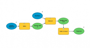
This example explains how to use model builder in ArcGIS. We show you how to create custom toolboxes and export models as Python scripts.
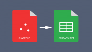
If you use ArcGIS 10.2 and above, you can use the “Table to Excel” tool to convert a shapefile table to Excel spreadsheet & export field aliases / subtypes

Some things in life are certain. In ArcGIS, it’s the Esri 999999 error. Here are techniques to troubleshoot this ArcMap error.
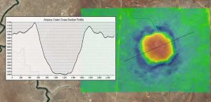
Topographic profiles are cross-sectional views showing elevation along a line with applications in engineering, hydrology, land use planning and more.

You can take any image, and you can vectorize it with ArcScan. This means you’ll spend less time digitizing and more time doing other important things.

Tech-savvy companies are using the location-allocation tool to find optimal location and target market. Here’s an ArcGIS solution to locate your company.
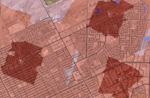
The ArcGIS Network Analyst Service Area analysis tool is perfect finding out just how far your cities firefighters, ambulance or paramedics can service.

If your letters and words are all uppercase or lowercase in a field, and you want to capitalize the first letter of each word, use this Python code block.