5 Maps That Explain the Arctic
What first comes to mind when you think of the Arctic?
Ice? Polar bears? Climate change?
It wasn’t until very recently that we’ve gotten a clearer picture of the Arctic.
….But just what are we mapping in the Arctic?
Geographic boundaries, climate change, ecology, geology, trading routes, oil exploration, the natural environment, and even the research that is taking place north of 60°.
5 Maps That Explain the Arctic
Maps are one of the most effective forms of communication ever developed:
They chart territory, they’re practical, and communicate ideas. So that’s why this list of Arctic maps is the best place to begin learning about the Arctic.
If you want answers about the Arctic, look no further. These visually inspiring Arctic maps will show you the way.
READ MORE: Antarctica Map and Satellite Image [Free]
1. ArkGIS Arctic Landscape
Stakeholders, decision-makers, and the general public get the whole picture with the Arctic Centre’s Region Maps. From economic boundaries to human activity.. to the natural environment… the Arctic Centre puts together piece-by-piece each element with its Arctic maps.
Boundaries:
- Exclusive Economic Zones (EEZ): Canada, Norway, Russia, Denmark (via Greenland), and the United States (via Alaska) are limited to their economies adjacent to their coasts. The waters beyond are considered international water.
Human Activity:
- Shipping Routes: Shipping routes are based on the satellite-based Automatic Identification System (AIS).
- Oil and Gas: Exploration and production wells used to retrieve underground petroleum or oil.
Natural Environment:
- Physical Oceanography: Bathymetry shows the underwater depth of the ocean floor. The SRTM30 PLUS Grid with roughly 1 km grid resolution.
- Sea Ice and Snow: Variables like sea ice and snow cover are important variables for scientists to understand the pace of climate change.
Ecology:
- Marine Mammals: Distribution and observations of marine animals for whales, seals, walruses and narwhals. It includes polar bear status and denning areas.
- Seabirds: This includes waterfowl, seabird and shorebird species richness.
- Fish: From Atlantic cod to Walleye Pollock, these layers show the probability of occurrence and observations for fish species.
2. ArMap: Arctic Research Mapping Application
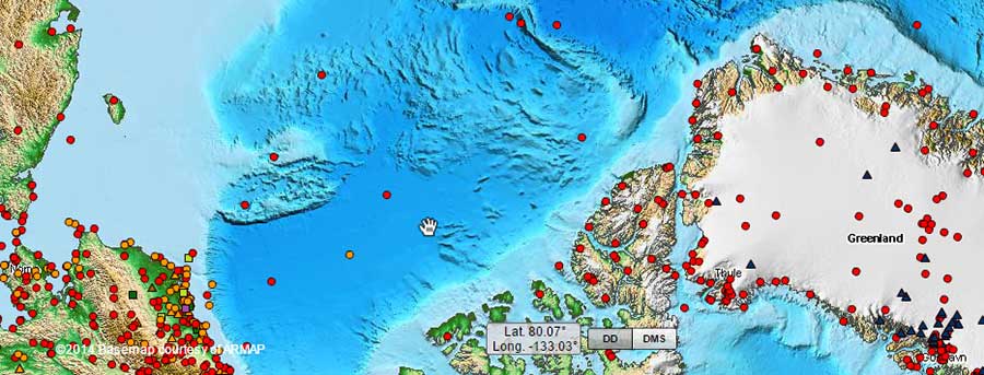
Have you ever wanted to tap into all the research in the Arctic?
Thousands of research projects are taking place in the Arctic. The Arctic Research Mapping Application (ARMAP) tries to illustrate them all in a simple web map. It supports Arctic science by displaying research projects, showing available data, and exploring possible collaborations.
Projects range from biological, geological, and meteorological to oceanography. This application displays Arctic vegetation, glaciers, permafrost, terrestrial biomes, and tree lines. ARMAP contains useful information on ship tracks, medical facilities, and arctic stations for your reference.
Users can navigate to areas of interest and explore research projects by location, year, funding program, investigator, discipline, keywords, and other variables. ARMAP is a valuable tool because researchers can see the “who”, “what”, “where”, and “when” in science.
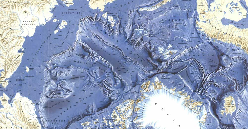
3. 1971 Arctic Ocean Floor
Early explorers thought the oceans were bottomless. After the invention of the sonic depth finder, suddenly our view of the oceans changed. They certainly weren’t bottomless… nor, were they flat. The featureless ocean became dynamic with trenches, ridges, and abyssal plains.
This Arctic Ocean Floor map first appeared in the October 1971 issue of National Geographic. The detail is extraordinary in such submarine terrains such as continental shelves, abyssal plains, ridges, and fracture zones. This Arctic map illustrates the various landmasses and the ocean floor in stunning relief.
4. Geologic Map of the Arctic
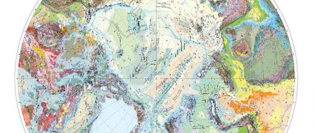
Canada’s Geo-mapping Frontiers initiated this project to improve geoscience knowledge in Canada’s north. Natural Resources Canada’s Geologic Map of the Arctic displays geologic structures of Canada’s Arctic north of 60°.
This Arctic map uses simple photogeologic principles and visual interpretation using a variety of free data sources. The data sets included enhanced magnetic data, LANDSAT imagery, and topographic (DEM) data.
5. The Arctic Risk Map
The Arctic Risk Map uses base data from a variety of sources. It offers meteorology, ocean, biological, wildlife, search and rescue, geographical, and activity as map data. But where these Arctic maps excel is in their environmental and safety indexes.
Environment Vulnerability Index: A location and season-specific index for the environmental vulnerability of marine resources concerning an oil spill as an external stressor. The vulnerability assessment evaluates the different ecological uses in about 100 areas of heightened ecological significance within the 17 Arctic Large Marine Ecosystems.
The Safety and Operability Index (SOI): The SOI is based on risk-influencing factors such as sea ice, visibility, temperature, distance from search and rescue, etc. It gives an aggregated score for each Arctic region for safety and operability factors in these regions.
Arctic Maps – Exploring the New & Unknown
The Arctic is in flux for ‘who’ is claiming ‘what’… The US, Russia, Canada, Norway and Danish are all staking their territory.
But no one can tap the Arctic until all countries agree. For instance, mineral extraction, natural gas, as well as potential shortcuts for shipping routes… the Arctic may be one of the last great frontiers for human development.
NASA has some models forecasting ice-free summers in the Arctic Ocean. Disappearing sea ice jeopardizes polar bears because they have less time to hunt. The result is a shrinking polar bear population. Seals, walruses, and seabirds have shorter periods for nesting and feeding.
Whether it’s human activity or the natural environment, these 5 Arctic maps help you truly understand the Great North.


