Satellite Pour l’Observation de la Terre (SPOT)

Satellite Pour l’Observation de la Terre (SPOT)
You already know that the longest-running Earth observation mission to supply you with Earth imagery is the Landsat mission.
That much is clear.
But how about the second longest-running? The French Satellite Pour l’Observation de la Terre (SPOT Satellite) holds the championship title.
In English, SPOT satellite means “satellite to observe Earth”. And in 1986, SPOT single-handedly became one of the most sophisticated Earth observation satellites of its time. It had an impressive ground resolution of 10 meters… while Landsat-5 rivaled with 30 meters.
The Remarkable History of the French SPOT Satellite
Silently, SPOT missions have orbited the Earth for over 30 years. (Landsat is over 40 years old.) SPOT is the unsung hero of satellite missions.
It played a vital role in the Chornobyl nuclear power plant disaster in Ukraine. It monitors vegetation, land use planning, environment, agriculture, military, and natural resource management. And it can even obtain stereo pairs for digital elevation models.
SPOT satellite has an amazing history. Here is a summary of the timeline, bands, and applications with a spectral, spatial, and temporal resolution of the SPOT satellite family.
SPOT Satellite Timeline: SPOT-1 to SPOT-7
SPOT-1 was launched by the French Space Agency (CNES – Centre national d’études spatiales. It really invented the future because it was one of the highest resolution optical satellites at this time. CNES initiated SPOT satellites 1 to 5. Astrium continued the SPOT family of satellites with SPOT-6. The image archive of SPOT-1 to SPOT-5 is impressive. It has 30 million images at resolutions of 20 to 2.5 meters for purchase.
SPOT-7 (Azersky) was launched on June 30, 2014. It continued SPOT’s imagery services of high-resolution, wide-swath data. Airbus Defense and Space sold SPOT-7 to Azerbaijan-s Azercosmos space agency. However, the rights to future SPOT satellites remain in Airbus Defense and Space. The service life for the constellation SPOT satellites is 10 years ensuring service continuity from the SPOT family.
Private organizations like Astrium are distributors of SPOT satellite imagery. This includes historical imagery.
Band Designations
The SPOT satellite constellation offers acquisition and a revisit capacity for anywhere in the world, every day. SPOT produces two high-resolution optical images. The multispectral mode is in the red, green, and infrared bands of the EM spectrum. The panchromatic mode is a single wideband in the visible part of the spectrum with higher resolution.
SPOT-5 added the HRS (High-Resolution Stereoscopic) imaging instrument. This instrument allowed the simultaneous acquisition of stereo pairs. You can derive elevation surfaces because stereo pairs give depth.
The VEGETATION instrument can be found on SPOT-4 and onward. It acts independently of the HRVIR (Visible & Infrared High-Resolution) sensors. This instrument can cover almost all the Earth’s surface in a day because of its swath size of 2250 km. It captures reflected light in four spectral bands (blue, red, near-infrared, and middle-infrared).
Sounds neat? It is. Here’s a look at each SPOT satellite band in detail.
SPOT-1 to SPOT-3
The first three satellites had identical payloads. It consisted of two identical HRV (Visible High-Resolution) optical instruments – multispectral and panchromatic mode. One of the key advantages of SPOT-1 was its 60 km imaging swath.
SPOT-1 captured visible (reflected light) bands in the spectrum of green, red, and near-infrared bands (NIR) with a spatial resolution of 20 meters.
The panchromatic image covers 0.51 to 0.73 µm in a single spectral band. This band had a ground resolution of 10 meters.
SPOT-1 to SPOT-3 Multispectral Mode
High-Resolution Visible (HRV) Sensors:
| Band | Type | Spectral Range | Resolution |
|---|---|---|---|
| Band 1 | Green | 0.50 – 0.59 µm | 20 m |
| Band 2 | Red | 0.61 – 0.68 µm | 20 m |
| Band 3 | Near infrared | 0.79 – 0.89 µm | 20 m |
SPOT-1 to SPOT-3 Panchromatic Mode
| Type | Spectral Range | Resolution |
|---|---|---|
| Panchromatic | 0.51 – 0.73 µm | 10 m |
SPOT-4
SPOT-4 broke new ground by adding a short-wave infrared (SWIR) band. The SWIR band boosted SPOT from its mold. But other than this addition, SPOT-4 was really a clone of older SPOT satellites.
There was a need to capture Earth’s plant cover and monitor long-term environmental change. This is why SPOT-4 added a VEGETATION instrument on board. The VEGETATION instrument covers virtually every portion of the Earth with a coarse 1 km resolution cell size.
The VEGETATION instrument acts independently of the HRVIR (Visible & Infrared High-Resolution) sensors. This instrument can cover almost all the Earth’s surface in a day because of its swath size of 2250 km. It captures reflected light in four spectral bands (blue, red, near-infrared, and middle-infrared).
SPOT-4 Multispectral Mode
| Band | Type | Spectral Range | Resolution |
|---|---|---|---|
| Band 1 | Green | 0.50 – 0.59 µm | 20 m |
| Band 2 | Red | 0.61 – 0.68 µm | 20 m |
| Band 3 | Near infrared | 0.78 – 0.89 µm | 20 m |
| Band 4 | Short-wave infrared (SWIR) | 1.58 – 1.75 µm | 20 m |
SPOT-4 Panchromatic Mode
| Type | Spectral Range | Resolution |
|---|---|---|
| Panchromatic | 0.51 – 0.73 µm | 10 m |
SPOT-5
The fifth SPOT satellite brings enhanced capabilities in terms of spatial resolution. The panchromatic band is capable of producing images at a 2.5-meter resolution. The multispectral images are at 10-meter resolution and the SWIR band is at 20-meter resolution.
The stereo instrument on SPOT-5 delivers three-dimensional products like Digital Elevation Models. These products can be used in applications including relief maps, terrain analysis, and water flow in hydrology.
The VEGETATION sensor remains unchanged on the fourth SPOT satellite. It ensures the continuity of global vegetation monitoring at a 1 km resolution.
SPOT-5 Multispectral Mode
| Band | Type | Spectral Range | Resolution |
|---|---|---|---|
| Band 1 | Green | 0.50 – 0.59 µm | 10 m |
| Band 2 | Red | 0.61 – 0.68 µm | 10 m |
| Band 3 | Near infrared | 0.78 – 0.89 µm | 10 m |
| Band 4 | Short-wave infrared (SWIR) | 1.58 – 1.75 µm | 20 m |
SPOT-5 Panchromatic Mode
| Type | Spectral Range | Resolution |
|---|---|---|
| Panchromatic | 0.45 – 0.71 µm | 2.5 m |
SPOT-6 and SPOT-7
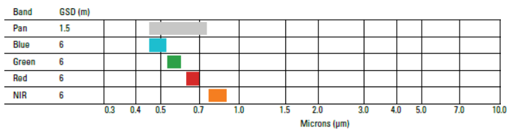
From start to finish, the SPOT satellite family has delivered consistent improvements. SPOT-6 is no exception. It delivers multispectral (R, G, B, and NIR) at 6 m resolution and panchromatic images at 1.5 resolution.
SPOT-6 and SPOT-7 are identical. They can provide a daily revisit everywhere on Earth with a 60 km × 60 km swath. The service life for the constellation SPOT satellites is 10 years.
The sixth SPOT satellite delivers multispectral (red, green, blue, and near-infrared) images in 6-meter resolution. Panchromatic images have a spatial resolution of 1.5 meters.
SPOT-6 and SPOT-7 (Azersky) Multispectral Mode
| Type | Spectral Range | Resolution |
|---|---|---|
| Blue | 0.45 – 0.52 µm | 6 m |
| Green | 0.53 – 0.59 µm | 6 m |
| Red | 0.61 – 0.68 µm | 6 m |
| Near infrared | 0.78 – 0.89 µm | 6 m |
SPOT-6 and SPOT-7 Panchromatic Mode
| Type | Spectral Range | Resolution |
|---|---|---|
| Panchromatic | 0.45 – 0.71 µm | 1.5 m |
Uses and Applications
You’ll be awe-struck at the down-to-earth applications of SPOT satellites.
SPOT satellites have spotted the world’s largest floods, wildfires, and human-caused events because of their long-lived history.
It’s kept a close eye on our changing planet – natural and man-made – and archived it for future analysis.
1. Satellite Monitoring of Chernobyl

Ten days after the Chernobyl nuclear disaster, SPOT-1 provided useful images from the sky of the highly contaminated zone. And for a quarter-century onward, SPOT satellites have continued mapping decontamination activities.
115,000 people were evacuated because of the Chernobyl disaster. This area was known as the “exclusion zone” which is a 30 km buffer around the nuclear power plant. The evacuation area could only be seen by satellite. Satellite technology worked best to cover the exclusion zone.
The first sign of recovery was found in 1988. SPOT-1 uncovered photosynthesis using the near-infrared sensor. Over the years, the SPOT family has kept a watchful eye on new infrastructure, decontamination activities, and reforestation of the area.
2. Digital Elevation Models

If you’re looking for 3D terrain models, SPOT satellite HRS stereo viewing instruments are vital in providing this data.
Digital Elevation Models can be produced from stereo satellite imagery from SPOT-5, SPOT-6, and SPOT-7 using photogrammetry techniques. Photogrammetry measures the apparent shift in relative positions of Earth when viewed in different locations.
In this day in age, there are hundreds of 3D terrain modeling applications: mobile phone network planning, hydrologic modeling, relief maps, volume measurements, and more.
3. Humanitarian Crisis
A new area of study is GEOINT. This stands for Geospatial Intelligence, GEOINT (GEOspatial INTelligence). GEOINT gathers intelligence about human activity on Earth derived from the exploitation and analysis of satellite and aerial imagery.
SPOT satellite imagery was used to look at camps for Syrian Refugees in Turkish territory. Photo interpreters studied the evolution of camps and capacity. Photo interpreters could distinguish sanitary facilities, stores, warehouses, and the number of shelters.
Satellite imagery was a means of gathering information safely. From an empty agricultural field to the formation of a refugee camp, SPOT satellites prove refugee camps can be monitored from space.
SPOT Satellite Questions
The green, red and near-infrared bands have a resolution of 20 meters. The panchromatic band has a ground resolution of 10 meters representing a single pixel.
It was launched on February 22, 1986, and decommissioned on December 31, 1999. This is approximately a 14-year span the satellite was in orbit.
Although SPOT-1 was initiated by CNES, historical SPOT imagery is available from private organizations.
It has 4 spectral bands – green, red, near-infrared, and panchromatic bands.
The spatial resolution primarily has been improved. The panchromatic band is 2.5 meters, multiresolution bands are 10m and SWIR is 20m.
Its History
- SPOT-1 was launched on February 22, 1986, with partners Belgium and Sweden. This marked the beginning of the incredible SPOT satellite era. Launch date: February 22, 1986. Deactivated: December 31, 1990
- SPOT-2 was its next mission in 1990. It orbited Earth for an incredible 19 years and was deactivated in July 2009. Launch date: January 22, 1990. Deactivated: July 29, 2009
- From long lifespan to short, SPOT-3 was short-lived. It was launched in 1993 with a lifespan of 4 years. Failure was because of issues with its stabilization system. Launch date: January 22, 1990. Deactivated: July 29, 2009
- SPOT-4 launched on March 24, 1998, with a shelf-life of 15 years. In July 2013, it stopped functioning. Launch date: March 24, 1998. Deactivated: July 2013
- SPOT-5 was launched in 2002 and remains in orbit. The HRS (High-Resolution Stereoscopic) imaging instrument also allows simultaneous acquisition of stereo pairs. Launch date: May 3, 2002. Deactivated: N/A
- SPOT-6 was launched into orbit on September 9, 2012, by Astrium to continue SPOT satellite imagery services of high-resolution, wide-swath data. Launch date: September 9, 2012. Deactivated: N/A
- SPOT-7 (identical to SPOT-6) was launched on June 30, 2014. Airbus Defense and Space sold SPOT-7 to Azerbaijan-s Azercosmos space agency and has the name of Azersky. Launch date: June 30, 2014. Deactivated: N/A
- Image Credit: SPOT Products: © [2012] Airbus DS, Licensed by BlackBridge Geomatics Corp. SPOT-6 New York City


It is helpful.
Thanks Jacob