What Is Terrestrial Laser Scanning?

Terrestrial laser scanning (TLS) is a LiDAR system that scans from the ground. Unlike airborne LIDAR, terrestrial LiDAR generates a point cloud at ground level. Because it’s angled horizontally, it’s ideal for inspecting buildings, forest structures, and more.
How Does Terrestrial Laser Scanning Work?
Terrestrial laser scanning works by sending out thousands of laser pulses. These pulses hit objects and bounce back to the scanner. The time it takes for this bounce-back tells us how far away something is.
The scanner does this thousands of times per second, covering surfaces in all directions. This creates a dense group of points, called a “point cloud”. How accurate is terrestrial LiDAR? It’s typically less than 10 cm.
The software then takes these points. It turns them into a 3D model of the area. This model shows the shapes and sizes of objects very clearly. Scanners also capture colors in RGB. As they take photos during a scan, this adds real-life textures to the 3D models.
NOTE
Terrestrial Laser Scanning Equipment
Terrestrial laser scanning equipment is a high-tech setup. The heart of the system is the laser scanner, itself. As mentioned already, it emits laser pulses to measure millions of laser points of the scanned area.

For outdoor scanning, GPS provides geolocation data. Whereas the IMU tracks the scanner’s orientation and movement. Together, they track its position and angle so the data is accurate and well-oriented.
Finally, the scanner mount or tripod provides stability. The laser scanner is mounted on a stable platform to ensure precise measurements. This setup allows the scanner to operate efficiently. It can also cover various angles without moving the actual device too much.
There is other equipment associated with terrestrial laser scanners. For instance, it needs a power supply to keep the scanner running. While data storage saves the point clouds, we also use software to process the data.
Use Cases and Applications
Because terrestrial laser scanning can build detailed 3D models, we can use it in different industries.

- Construction – It’s great for checking on buildings, bridges, and construction sites. Because it can provide accurate 3D models, it ensures structures are built to specification.
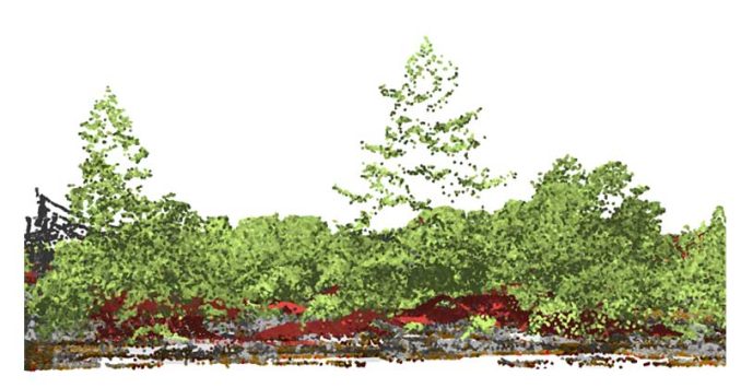
- Forestry: Terrestrial laser scanning gathers information about tree heights and canopy structure. From sample plots, laser scans provide accurate biomass estimations.
- Mining: it can assess volume calculations at quarry sites. Plus, it provides accurate data for managing extraction. The bottom line is that it helps plan and ensure safety.
- Urban Planning: Terrestrial laser scanners go into mapping cityscapes and infrastructure. Planners use the detailed data from point clouds for designing city layouts, traffic flow, and public spaces.
- Heritage and Archaeology: Most of the spotlight is on airborne LiDAR as it has made headway finding lost civilizations. But terrestrial LiDAR has a key role too. We use it mostly for documenting historical sites with ground scans.
We use terrestrial laser scanning in so many ways, from saving historical sites to building safer bridges. Similar to other LiDAR use cases, it gives us a clear picture of our world, helping us make smarter decisions.
Terrestrial LiDAR Scanning
Terrestrial laser scanning has proven itself as a research tool across various fields. Its unmatched precision allows us to produce detailed 3D models providing us with versatility and value.
Now, we’d like to turn things over to you. How do you use terrestrial laser scanners? We’d love to hear all the interesting ways that you’re using this ground-based survey technology.


